
Bradfield Highway, Sydney
Encyclopedia
Sydney
Sydney is the most populous city in Australia and the state capital of New South Wales. Sydney is located on Australia's south-east coast of the Tasman Sea. As of June 2010, the greater metropolitan area had an approximate population of 4.6 million people...
, New South Wales
New South Wales
New South Wales is a state of :Australia, located in the east of the country. It is bordered by Queensland, Victoria and South Australia to the north, south and west respectively. To the east, the state is bordered by the Tasman Sea, which forms part of the Pacific Ocean. New South Wales...
, Australia
Australia
Australia , officially the Commonwealth of Australia, is a country in the Southern Hemisphere comprising the mainland of the Australian continent, the island of Tasmania, and numerous smaller islands in the Indian and Pacific Oceans. It is the world's sixth-largest country by total area...
. At 2.4 km long it is one of the shortest highways in Australia.
The highway was named after Dr John Bradfield, who oversaw the tendering process for the construction of the Sydney Harbour Bridge
Sydney Harbour Bridge
The Sydney Harbour Bridge is a steel through arch bridge across Sydney Harbour that carries rail, vehicular, bicycle and pedestrian traffic between the Sydney central business district and the North Shore. The dramatic view of the bridge, the harbour, and the nearby Sydney Opera House is an iconic...
.
The Bradfield Highway opened in 1932 and begins at the end of the Western Distributor
Western Distributor
The Western Distributor is a primarily elevated small freeway in Sydney, New South Wales, Australia that links Victoria Road, White Bay , with the Bradfield Highway at the southern end of the Sydney Harbour Bridge...
in the Sydney
Sydney
Sydney is the most populous city in Australia and the state capital of New South Wales. Sydney is located on Australia's south-east coast of the Tasman Sea. As of June 2010, the greater metropolitan area had an approximate population of 4.6 million people...
CBD, crosses the Sydney Harbour Bridge
Sydney Harbour Bridge
The Sydney Harbour Bridge is a steel through arch bridge across Sydney Harbour that carries rail, vehicular, bicycle and pedestrian traffic between the Sydney central business district and the North Shore. The dramatic view of the bridge, the harbour, and the nearby Sydney Opera House is an iconic...
and ends at the Warringah Freeway
Warringah Freeway
The Warringah Freeway is a major road in Sydney, New South Wales, Australia. This freeway forms part of the Sydney Orbital Network to provide access to most of the suburbs in Sydney and is also a major route to the north, south, east and west of the metropolis.-History:Planning began in 1951...
in North Sydney
North Sydney, New South Wales
North Sydney is a suburb and commercial district on the Lower North Shore of Sydney, in the state of New South Wales, Australia. North Sydney is located 3 kilometres north of the Sydney central business district and is the administrative centre for the local government area of North Sydney...
(just North of the Pacific Highway
Pacific Highway (Australia)
The Pacific Highway is a major transport route along part of the east coast of Australia and is part of Australia's national route 1.It is 960 km long and links Sydney, the capital of New South Wales, to Brisbane, the capital of Queensland, along the coast, via Gosford, Newcastle, Taree, Port...
intersection). In 2001, 159,587 vehicles a day used the highway http://sydneyharbourbridge.info.
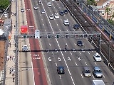
The Bradfield Highway carries six lanes of traffic across the eight lane Sydney Harbour Bridge
Sydney Harbour Bridge
The Sydney Harbour Bridge is a steel through arch bridge across Sydney Harbour that carries rail, vehicular, bicycle and pedestrian traffic between the Sydney central business district and the North Shore. The dramatic view of the bridge, the harbour, and the nearby Sydney Opera House is an iconic...
. The other two traffic lanes on the Sydney Harbour Bridge are used for the Cahill Expressway
Cahill Expressway
The Cahill Expressway is the first true freeway constructed in Sydney, Australia. It starts from the Eastern Distributor and Cross City Tunnel in Woolloomooloo, and runs through a series of sunken cuttings and tunnels between the Royal Botanical Gardens and The Domain...
, which run only in southbound on the bridge. During peak periods three out of the six lanes are reversed, giving a 2 × 4, 3 × 3 or 5 × 1 flow. The default is 4 × 2. (Four north, two south) The direction of the lanes is indicated by electronic signage above each lane. The lanes are numbered one to six from west to east. Lane six was also reversed prior to 1990 during the evening rush hour, giving a 6 × 0 flow, but this no longer occurs because of changes made to the Warringah Freeway to accommodate the Sydney Harbour Tunnel.
In August 1992, the Sydney Harbour Tunnel
Sydney Harbour Tunnel
The Sydney Harbour Tunnel is a twin-tube road tunnel in Sydney, Australia. The tunnel was completed and opened to traffic in August 1992 to provide a second vehicular crossing of Sydney Harbour to alleviate congestion on the Sydney Harbour Bridge....
opened, which helped to relieve congestion on the Bradfield Highway.
Exits and Interchanges
| Bradfield Highway | |||
| Northbound exits | Distance to Brisbane (km) |
Distance to Sydney CBD (km) |
Southbound exits |
| End Bradfield Highway continues as Warringah Freeway Warringah Freeway The Warringah Freeway is a major road in Sydney, New South Wales, Australia. This freeway forms part of the Sydney Orbital Network to provide access to most of the suburbs in Sydney and is also a major route to the north, south, east and west of the metropolis.-History:Planning began in 1951... to North Sydney North Sydney, New South Wales North Sydney is a suburb and commercial district on the Lower North Shore of Sydney, in the state of New South Wales, Australia. North Sydney is located 3 kilometres north of the Sydney central business district and is the administrative centre for the local government area of North Sydney... / Newcastle Newcastle, New South Wales The Newcastle metropolitan area is the second most populated area in the Australian state of New South Wales and includes most of the Newcastle and Lake Macquarie Local Government Areas... / Brisbane |
934 | 3 | Start Bradfield Highway from Warringah Freeway Warringah Freeway The Warringah Freeway is a major road in Sydney, New South Wales, Australia. This freeway forms part of the Sydney Orbital Network to provide access to most of the suburbs in Sydney and is also a major route to the north, south, east and west of the metropolis.-History:Planning began in 1951... |
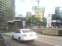
| TOLL PLAZA | |||
| SYDNEY HARBOUR BRIDGE Sydney Harbour Bridge The Sydney Harbour Bridge is a steel through arch bridge across Sydney Harbour that carries rail, vehicular, bicycle and pedestrian traffic between the Sydney central business district and the North Shore. The dramatic view of the bridge, the harbour, and the nearby Sydney Opera House is an iconic... |
935 | 2 | SYDNEY HARBOUR BRIDGE Sydney Harbour Bridge The Sydney Harbour Bridge is a steel through arch bridge across Sydney Harbour that carries rail, vehicular, bicycle and pedestrian traffic between the Sydney central business district and the North Shore. The dramatic view of the bridge, the harbour, and the nearby Sydney Opera House is an iconic... |
| Start Bradfield Highway continues from Western Distributor Western Distributor The Western Distributor is a primarily elevated small freeway in Sydney, New South Wales, Australia that links Victoria Road, White Bay , with the Bradfield Highway at the southern end of the Sydney Harbour Bridge...  |
936.5 | 0.5 | Wollongong Wollongong, New South Wales Wollongong is a seaside city located in the Illawarra region of New South Wales, Australia. It lies on the narrow coastal strip between the Illawarra Escarpment and the Pacific Ocean, 82 kilometres south of Sydney... , Canberra Cahill Expressway Cahill Expressway The Cahill Expressway is the first true freeway constructed in Sydney, Australia. It starts from the Eastern Distributor and Cross City Tunnel in Woolloomooloo, and runs through a series of sunken cuttings and tunnels between the Royal Botanical Gardens and The Domain...  |
| End Cahill Expressway continues as Western Distributor Western Distributor The Western Distributor is a primarily elevated small freeway in Sydney, New South Wales, Australia that links Victoria Road, White Bay , with the Bradfield Highway at the southern end of the Sydney Harbour Bridge... to Ashfield Ashfield, New South Wales Ashfield is a suburb in the inner-west of Sydney, in the state of New South Wales, Australia. Ashfield is about 9 kilometres south-west of the Sydney central business district and is the administrative centre for the local government area of the Municipality of Ashfield.The official name for the... / Parramatta Parramatta, New South Wales Parramatta is a suburb of Sydney, in the state of New South Wales, Australia. It is located in Greater Western Sydney west of the Sydney central business district on the banks of the Parramatta River. Parramatta is the administrative seat of the Local Government Area of the City of Parramatta... |
|||
See also
- Freeways in AustraliaFreeways in AustraliaThis is a list of freeways and motorways in Australia, sorted by states and territories and their corresponding routes. This list includes toll roads such as the CityLink freeway system in Melbourne. This list has over 70 entries...
- Freeways in Sydney
Freeways near the Harbour Bridge
M1 Cahill Expressway
Cahill Expressway
The Cahill Expressway is the first true freeway constructed in Sydney, Australia. It starts from the Eastern Distributor and Cross City Tunnel in Woolloomooloo, and runs through a series of sunken cuttings and tunnels between the Royal Botanical Gardens and The Domain...
, Bradfield Highway, M1 Sydney Harbour Tunnel
Sydney Harbour Tunnel
The Sydney Harbour Tunnel is a twin-tube road tunnel in Sydney, Australia. The tunnel was completed and opened to traffic in August 1992 to provide a second vehicular crossing of Sydney Harbour to alleviate congestion on the Sydney Harbour Bridge....
, M1 F1 Warringah Freeway
Warringah Freeway
The Warringah Freeway is a major road in Sydney, New South Wales, Australia. This freeway forms part of the Sydney Orbital Network to provide access to most of the suburbs in Sydney and is also a major route to the north, south, east and west of the metropolis.-History:Planning began in 1951...
, M1 Gore Hill Freeway
Gore Hill Freeway
The Gore Hill Freeway is a major freeway in Sydney, New South Wales, Australia. This freeway forms part of Metroad 1 andthe Sydney Orbital Network to provide access to most of the suburbs in Sydney and is also a major route to the north, south, east and west of the metropolis.It connects to the...
and M4 Western Distributor
Western Distributor
The Western Distributor is a primarily elevated small freeway in Sydney, New South Wales, Australia that links Victoria Road, White Bay , with the Bradfield Highway at the southern end of the Sydney Harbour Bridge...
.