
Bowling and Barkerend
Encyclopedia
City of Bradford
The City of Bradford is a local government district of West Yorkshire, England with the status of a city and metropolitan borough. It is named after its largest settlement, Bradford, but covers a far larger area which includes the towns of Keighley, Shipley, Bingley, Ilkley, Haworth, Silsden and...
.
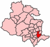
Bowling and Barkerend covers the area immediately east and south of Bradford centre. It includes the areas known as Barkerend
Barkerend
Barkerend is an inner-city area in the Bowling and Barkerend ward of the Bradford District, in the English county of West Yorkshire.Barkerend is located to the east of Bradford city centre....
, Bowling
Bowling (disambiguation)
Bowling is a competitive and recreational sport. Variants include:* Ten-pin bowling, the most popular type of bowling today* Nine-pin bowling* Five-pin bowling, a bowling variant which is played only in Canada* Duckpin bowling* Candlepin bowling...
, East Bowling
East Bowling
East Bowling is an area of Bradford, West Yorkshire, England, located approximately one mile south of Bradford city centre.-Landmarks:In the centre of East Bowling is Bowling Park with its fossil tree, and the nearby Bolling Hall museum. Churches of several faiths fall within the area. These...
, Swaine Green, Cutler Heights
Cutler Heights
Cutler Heights is a district of Bradford, West Yorkshire, England. It is known for its many industrial estates....
and Goose Hill. St Clement's Church on Barkerend Road has Pre-Raphaelite decorations by Sir Edward Burne-Jones
Edward Burne-Jones
Sir Edward Coley Burne-Jones, 1st Baronet was a British artist and designer closely associated with the later phase of the Pre-Raphaelite movement, who worked closely with William Morris on a wide range of decorative arts as a founding partner in Morris, Marshall, Faulkner, and Company...
. Note that West Bowling
West Bowling
West Bowling are an amateur rugby league club situated in Bradford, West Yorkshire, England. They currently compete in the National Conference League.West Bowling play their home games at Bankfoot Cricket Club, next to Odsal stadium...
is in neighbouring Little Horton Ward.
Boundaries
It is bounded on the west side by the Bradford Inner Ring Road (Canal Road, Shipley Airedale Road, Croft Street) then the railway line from Bradford Interchange to Halifax until it meets New Cross Street where the boundary heads south east around the edge of Parkside (New Cross Street, Avenue Road, Parkside Road and along the edge of the Cemetery). On the south side the boundary follows the Outer Ring Road (Rooley Lane, Sticker Lane) past Wakefield Road then forks east on Cutler Heights Lane which becomes Dick Lane as it curves northward. The boundary then follows the Bradford to Leeds railway line west. The boundary heads north again along Birksland Street and continues the same line between Gledhill Road and Whitehead Street, through the grounds of Leeds Road Hospital and along the edge of the allotments to Barkerend Road. Then north east along the path marking the edge of Bradford Moor Golf Course to re-join the Outer Ring Road (Killinghall Road). Along the north side the boundary forks west off Killinghall Road onto Northcote Road then turns west along Otley Road. The boundary loops south round Undercliffe Cemetery and back to Otley Road, as the road turns south the boundary continues west along the edge of the school fields to Bolton Road and continues west down the hill to Canal Road as it feeds into the inner ring road.2011 Election
In the 2011 election one of the three councillor posts was up for re-election.2010 Election
In the 2010 election one of the three councillor posts was up for re-election.2008 Election
In the 2008 election one of the three councillor posts was up for re-election.2007 Election
In the 2007 Election one of the three councillor posts was up for re-election.In July 2006 Rupert Oliver, elected for the Liberal Party, resigned the Liberal Party & joined the Labour Party.
2006 Election
In the 2006 Election only one of the three councillor posts was up for re-election.The turnout does not include spoiled papers & is a percentage of the 2007 electorate.
Percentages changed are expressed compared to the overall party showings in 2004.
2004 election
The ward was created after boundary changes in the 2004 electionAll three councillor posts were up for election and each elector had three votes.
The turnout is estimated as a third of the total votes cast as a fraction of the 2007 electorate. Candidate percentages are expressed as a fraction of this turnout estimate.
The same results expressed by party