
Bottle Cove
Encyclopedia
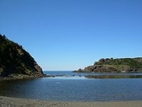
Bottle Cove is located on the west coast of Newfoundland
. It opens directly onto the Gulf of Saint Lawrence, although is typically included in the regional descriptor, “Bay of Islands,” which lies at the mouth of the Humber Arm. Bottle Cove is also referred to as Bottle Cove Provincial Park and as Bottle Cove Day Park (no amenities) in official Parks documentation.
Bottle Cove lies in the Newfoundland Time Zone
(UTC-3.5) and observes daylight saving time
. Newfoundland is considered to have a humid continental climate. Winter day temperatures in the area of Bottle Cove tend to average 0 degrees C (32 degrees Fahrenheit). Summer has an average day temperature of around 16°C (61°Fahrenheit).
Bottle Cove is a popular spot with locals and tourists alike, and it is renowned for its rugged, pristine beauty.
Bottle Cove is believed to have been used as a French fishing station from the early 16th century. A fishing station was always seasonal, with fishermen setting up a temporary base and then returning to their home country at the end of the fishing season. Given the proximity of Bottle Cove—especially by sea—to Port-aux-Basques which was a fishing station for Basque fishermen during the 15th century, it is highly likely that the cove was frequented by Basque fisherman before French fisherfolk laying claim to it. The name of the cove is an Anglicisation of “bateau” which is French for “boat”. “Bottle” fits the cove well, though, due to its almost perfect circular shape and narrowly separated headlands opening to the Gulf.
Census records for 1891 show 38 people living in Bottle Cove. The 1921 Census lists seven families (42 people in all) living in Bottle Cove. The cove was used as a port for local fishermen during the 20th century, until Little Port, two kilometres away, was developed as a modern port and safe harbour for boats in the 1970s. Today, a few fishing sheds remain along the shore of Bottle Cove. Currently, there are six homes to be found dotted about the Cove itself.
Bottle Cove, and nearby Lark Harbour and York Harbour were outport settlements
until 1961, when a road to Corner Brook was completed and the communities no longer needed to travel by boat to buy supplies and obtain key services. Residential telephones became available to the community in the early 1970s.
Bottle Cove is renowned for its geological richness. The cliffs surrounding the cove are part of the Appalachian Mountains
. Much of the rock formations visible in the Cove are “part of a slice of rocks, tens of kilometres across, known as the Humber Arm Allochthon”. This layer of rock was pushed up and over sedimentary rocks during tectonic plate movement. “As the allochthon
was moving, shales underneath it were broken up and mixed with sedimentary, volcanic and ocean crust rocks (ophiolite) from the slice itself, to form material known as mélange”. In addition, rounded, bulbous masses—dark green and red basalt pillow lava
s—thought to have been extruded under water can be seen at low tide. The sea has carved these sedimentary, mélange and lava rocks into curious and intriguing shapes. At low tide it is possible to walk to a sea-carved "cave" on the south side of the cove.
Bottle Cove is host to a raised wave-cut platform: “As the glaciers shrank inland from Gulf of St. Lawrence, they paused at the mouths of many fjords about 13000 years ago and sea level stabilized 35 m above its present level. Wave action, combined with intense frost action during the severe climate, cut this prominent intertidal platform into the solid rock. Eventual disappearance of the glaciers allowed the land to rebound and the old shoreline was left high and dry.” This platform forms part of one headland of the cove.

Newfoundland and Labrador
Newfoundland and Labrador is the easternmost province of Canada. Situated in the country's Atlantic region, it incorporates the island of Newfoundland and mainland Labrador with a combined area of . As of April 2011, the province's estimated population is 508,400...
. It opens directly onto the Gulf of Saint Lawrence, although is typically included in the regional descriptor, “Bay of Islands,” which lies at the mouth of the Humber Arm. Bottle Cove is also referred to as Bottle Cove Provincial Park and as Bottle Cove Day Park (no amenities) in official Parks documentation.
Bottle Cove lies in the Newfoundland Time Zone
Newfoundland Standard Time Zone
Newfoundland Standard Time ' is a geographic region that keeps time by subtracting 3½ hours from Coordinated Universal Time , resulting in UTC−3:30, or 2½ hours during daylight saving time...
(UTC-3.5) and observes daylight saving time
Daylight saving time
Daylight saving time —also summer time in several countries including in British English and European official terminology —is the practice of temporarily advancing clocks during the summertime so that afternoons have more daylight and mornings have less...
. Newfoundland is considered to have a humid continental climate. Winter day temperatures in the area of Bottle Cove tend to average 0 degrees C (32 degrees Fahrenheit). Summer has an average day temperature of around 16°C (61°Fahrenheit).
Bottle Cove is a popular spot with locals and tourists alike, and it is renowned for its rugged, pristine beauty.
History
There is little specific written documentation available regarding the history of Bottle Cove. Small evidence of possible use by members of the Little Passage culture (dating to approximately 1200-1500 AD) has been found in the cove (e.g., an arrow flint point, found by Averil Childs in 1971).Bottle Cove is believed to have been used as a French fishing station from the early 16th century. A fishing station was always seasonal, with fishermen setting up a temporary base and then returning to their home country at the end of the fishing season. Given the proximity of Bottle Cove—especially by sea—to Port-aux-Basques which was a fishing station for Basque fishermen during the 15th century, it is highly likely that the cove was frequented by Basque fisherman before French fisherfolk laying claim to it. The name of the cove is an Anglicisation of “bateau” which is French for “boat”. “Bottle” fits the cove well, though, due to its almost perfect circular shape and narrowly separated headlands opening to the Gulf.
Census records for 1891 show 38 people living in Bottle Cove. The 1921 Census lists seven families (42 people in all) living in Bottle Cove. The cove was used as a port for local fishermen during the 20th century, until Little Port, two kilometres away, was developed as a modern port and safe harbour for boats in the 1970s. Today, a few fishing sheds remain along the shore of Bottle Cove. Currently, there are six homes to be found dotted about the Cove itself.
Bottle Cove, and nearby Lark Harbour and York Harbour were outport settlements
Newfoundland outport
An outport is the term given for a small isolated coastal community in the Canadian province of Newfoundland and Labrador. Originally the term was just used for coastal communities on the island of Newfoundland but the term has also been adopted for those on the mainland area of Labrador as...
until 1961, when a road to Corner Brook was completed and the communities no longer needed to travel by boat to buy supplies and obtain key services. Residential telephones became available to the community in the early 1970s.
Points of interest
Captain James Cook charted the area in 1776. A cairn on the northern headland of Bottle Cove marks what Cook referred to as “Trail’s End” — the farthest point of this particular branch of the Humber Arm mapped by Cook. Locals tell how the detailed maps of this area created by Cook are still in maritime use.Bottle Cove is renowned for its geological richness. The cliffs surrounding the cove are part of the Appalachian Mountains
Appalachian Mountains
The Appalachian Mountains #Whether the stressed vowel is or ,#Whether the "ch" is pronounced as a fricative or an affricate , and#Whether the final vowel is the monophthong or the diphthong .), often called the Appalachians, are a system of mountains in eastern North America. The Appalachians...
. Much of the rock formations visible in the Cove are “part of a slice of rocks, tens of kilometres across, known as the Humber Arm Allochthon”. This layer of rock was pushed up and over sedimentary rocks during tectonic plate movement. “As the allochthon
Allochthon
thumb|right|250px|Schematic overview of a thrust system. The hanging wall block is called a [[nappe]]. If an [[erosion]]al hole is created in the nappe that is called a [[window |window]]...
was moving, shales underneath it were broken up and mixed with sedimentary, volcanic and ocean crust rocks (ophiolite) from the slice itself, to form material known as mélange”. In addition, rounded, bulbous masses—dark green and red basalt pillow lava
Pillow lava
Pillow lavas are lavas that contain characteristic pillow-shaped structures that are attributed to the extrusion of the lava under water, or subaqueous extrusion. Pillow lavas in volcanic rock are characterized by thick sequences of discontinuous pillow-shaped masses, commonly up to one metre in...
s—thought to have been extruded under water can be seen at low tide. The sea has carved these sedimentary, mélange and lava rocks into curious and intriguing shapes. At low tide it is possible to walk to a sea-carved "cave" on the south side of the cove.
Bottle Cove is host to a raised wave-cut platform: “As the glaciers shrank inland from Gulf of St. Lawrence, they paused at the mouths of many fjords about 13000 years ago and sea level stabilized 35 m above its present level. Wave action, combined with intense frost action during the severe climate, cut this prominent intertidal platform into the solid rock. Eventual disappearance of the glaciers allowed the land to rebound and the old shoreline was left high and dry.” This platform forms part of one headland of the cove.