

Bolshoy Tyuters
Encyclopedia
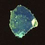
Bolshoi Tyuters is an island
Island
An island or isle is any piece of sub-continental land that is surrounded by water. Very small islands such as emergent land features on atolls can be called islets, cays or keys. An island in a river or lake may be called an eyot , or holm...
in the Gulf of Finland
Gulf of Finland
The Gulf of Finland is the easternmost arm of the Baltic Sea. It extends between Finland and Estonia all the way to Saint Petersburg in Russia, where the river Neva drains into it. Other major cities around the gulf include Helsinki and Tallinn...
of the Baltic Sea
Baltic Sea
The Baltic Sea is a brackish mediterranean sea located in Northern Europe, from 53°N to 66°N latitude and from 20°E to 26°E longitude. It is bounded by the Scandinavian Peninsula, the mainland of Europe, and the Danish islands. It drains into the Kattegat by way of the Øresund, the Great Belt and...
, located 75 km away from the coast of Finland
Finland
Finland , officially the Republic of Finland, is a Nordic country situated in the Fennoscandian region of Northern Europe. It is bordered by Sweden in the west, Norway in the north and Russia in the east, while Estonia lies to its south across the Gulf of Finland.Around 5.4 million people reside...
, to the south-east from Hogland
Hogland
Gogland or Hogland is an island in the Gulf of Finland of the Baltic Sea, located some 180 km west of Saint Petersburg and 35 km away from the coast of Finland . The island is a part of the Leningrad Oblast, Russia. The area of Hogland Island is approximately...
. The island is a part of the Leningrad Oblast
Leningrad Oblast
Leningrad Oblast is a federal subject of Russia . It was established on August 1, 1927, although it was not until 1946 that the oblast's borders had been mostly settled in their present position...
, Russia
Russia
Russia or , officially known as both Russia and the Russian Federation , is a country in northern Eurasia. It is a federal semi-presidential republic, comprising 83 federal subjects...
. The area is approximately 8.3 km². There are no permanent inhabitants, save for a lighthouse keeper. Bolshoi Tyuters has been known as the "mined island" because its minefields have not been cleared since World War II
World War II
World War II, or the Second World War , was a global conflict lasting from 1939 to 1945, involving most of the world's nations—including all of the great powers—eventually forming two opposing military alliances: the Allies and the Axis...
. From the 16th century to 1939, it was populated by Finns. After the Soviet Union had attacked Finland in the Winter War
Winter War
The Winter War was a military conflict between the Soviet Union and Finland. It began with a Soviet offensive on 30 November 1939 – three months after the start of World War II and the Soviet invasion of Poland – and ended on 13 March 1940 with the Moscow Peace Treaty...
, the island along with other Finnish islands in the Gulf of Finland
Gulf of Finland
The Gulf of Finland is the easternmost arm of the Baltic Sea. It extends between Finland and Estonia all the way to Saint Petersburg in Russia, where the river Neva drains into it. Other major cities around the gulf include Helsinki and Tallinn...
and communities in Finnish Karelia had to be ceded to Soviet Union 1940. It was a lively Finnish fisher and trading community with population 436 (1939). Many cargo and fishing ships were registered to the island. It had a 1772 built wooden church, Finnish graveyard, school, 1904 built lighthouse, Finnish Coast Guard station and weather forecast station. Tourism was growing livelihood in 1920-39. Islanders were among the Finnish evacuees
Evacuation of Finnish Karelia
As a result of the 1940 Moscow Peace Treaty that concluded the Winter War, Finland ceded the area of Finnish Karelia and other territories to the Soviet Union...
. After the war they were not permitted to return back to their homes like the rest of 422,000 Soviet evicted Finns. The name Tytärsaari means in Finnish - "Daughter Island" .
External links
The Mined IslandThe Map of Tytärsaari