
Bolivar Peninsula, Texas
Encyclopedia
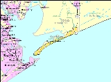
Bolivar Peninsula is a census-designated place
(CDP) in Galveston County
, Texas
, United States
. The population was 3,853 at the 2000 census.
system which routes calls to proper dispatchers and allows dispatchers to automatically view the address of the caller.
The name Bolivar came from Venezuelan hero Simon Bolivar
.
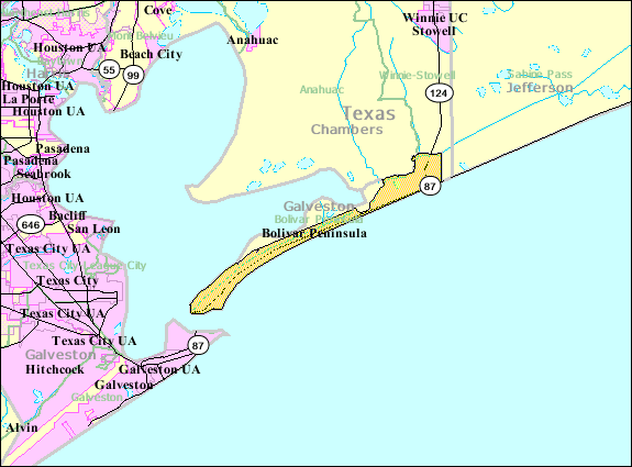 It forms a narrow strip of land in Galveston County, Texas
, separating the eastern part of Galveston Bay
from the Gulf of Mexico
. The peninsula's width ranges from half a mile down to a quarter-mile near the unincorporated community of Gilchrist
, where the peninsula is divided by Rollover Pass
.
According to the United States Census Bureau
, the CDP has a total area of 46.7 square miles (121 km²), of which, 45.2 square miles (117.1 km²) of it is land and 1.5 square miles (3.9 km²) of it (3.17%) is water.
As of the census
of 2000, there were 3,853 people, 1,801 households, and 1,138 families residing in the CDP. The population density
was 85.3 people per square mile (32.9/km²). There were 5,425 housing units at an average density of 120.0 per square mile (46.4/km²). The racial makeup of the CDP was 93.69% White, 0.47% African American, 0.80% Native American, 0.57% Asian, 2.80% from other races
, and 1.66% from two or more races. Hispanic or Latino of any race were 6.96% of the population.
There were 1,801 households out of which 18.0% had children under the age of 18 living with them, 52.3% were married couples
living together, 7.4% had a female householder with no husband present, and 36.8% were non-families. 31.3% of all households were made up of individuals and 12.9% had someone living alone who was 65 years of age or older. The average household size was 2.14 and the average family size was 2.65.
In the CDP the population was spread out with 17.0% under the age of 18, 5.6% from 18 to 24, 20.7% from 25 to 44, 35.1% from 45 to 64, and 21.6% who were 65 years of age or older. The median age was 48 years. For every 100 females there were 104.4 males. For every 100 females age 18 and over, there were 104.1 males.
The median income for a household in the CDP was $34,235, and the median income for a family was $42,448. Males had a median income of $36,477 versus $24,519 for females. The per capita income
for the CDP was $26,137. About 8.3% of families and 11.7% of the population were below the poverty line, including 13.4% of those under age 18 and 7.3% of those age 65 or over.
 Bolivar Peninsula residents are divided between the Galveston Independent School District
and the High Island Independent School District
.
The western portion of the Bolivar Peninsula, including the unincorporated communities of Port Bolivar
and Crystal Beach
, are within the Galveston Independent School District. That portion is served by the K-8 Crenshaw Elementary and Middle School, located on the island, and Ball High School
(9-12), located in Galveston
. The current Crenshaw building opened in 2005.
The eastern portion of the peninsula, including the unincorporated communities of Caplen
, Gilchrist
, and High Island
, is served by the High Island Independent School District.
Galveston College
serves all of the Bolivar Peninsula.
area.
The community holds a Mardi Gras
celebration along Texas State Highway 87 each year. Many people and groups, including beach bars, politicians, and school groups have krewe
s in the celebration. Brittanie Shey of the Houston Press
described the celebration as a "small town parade."
provides ferry
service from Port Bolivar
at the western end of the Bolivar Peninsula to Galveston
.
.jpg) At 7:10 UST on September 13, 2008 (2:10 AM local), Hurricane Ike
At 7:10 UST on September 13, 2008 (2:10 AM local), Hurricane Ike
made landfall at the east end of Galveston Island, Texas as the largest Atlantic tropical cyclone in recorded history. At the height of the storm, Ike’s cloud mass essentially covered the entire Gulf of Mexico. The Wind and Surge Destructive Potential Classification Scale, which was detailed in Tropical Cyclone Destructive Potential by Integrated Kinetic Energy (by Dr. Mark Powell and Dr. Tim Reinhold, April 2007) offers a new way to assess hurricane size and strength by calculating the total kinetic energy contained in a 1-meter deep horizontal slice of the storm at an elevation of 10 meters above the land or ocean surface. Using this type of calculation, the integrated kinetic energy was calculated for Ike and was found to be 25 percent greater than the comparable maximum estimate for Hurricane Katrina in 2005.
Hurricane Ike caused cataclysm
ic destruction of the Peninsula - reducing the region to rubble and causing severe, permanent change in the shoreline. Entire communities along the upper Texas coast were simply wiped out by Ike’s catastrophic storm surge. Ike’s effects were disproportionally felt near the long, low-lying Bolivar Peninsula which has typical elevations around 2 m. Despite being only a strong category 2 storm with maximum winds at landfall of 95 knots (49 m/s, Berg, 2009), Ike’s extremely large, long-lasting surge and waves devastated the peninsula. In Gilchrist, Texas
, NOAA aerial photography reveals complete destruction. The roll-over pass bridge was reduced to one lane. Of the 1,000 buildings in Gilchrist, 99.5% of them were knocked off of their foundations. Of the buildings off of the foundations, the storm demolished some and washed others onto swamplands behind Gilchrist.
The Bolivar Peninsula was just to the right of landfall, placing it on the strong side of the hurricane. H Wind reconstructions (Powell et al., 1998) show winds blowing strongly from offshore-to-onshore for most of the storm
, which acted to increase both surge
and wave
s. Surge is extremely important for the particular case of the Bolivar Peninsula, as it allowed large waves to penetrate inland into areas they could not otherwise have reached. Shoreline erosion was around 75 m, which undermined the piled foundations of oceanfront buildings. Most other houses in this area were reduced to either piles or slabs by large waves riding on surge, with only a very few remaining more or less intact. Peak coastal surges reached 21 feet (6.4 m). Water depths of at least 5 feet (1.5 m) covered all of the Bolivar Peninsula, with most areas covered by at least 15 feet (4.6 m) of water (not including wave action). Much of the southern part of Chambers County was also inundated by at least 12 feet (3.7 m) of water. According to post-storm analyses by both the National Oceanic and Atmospheric Administration’s (NOAA) Hurricane Research Division and Applied Research Associates (ARA), a research and engineering company, the best estimates of 3-second peak wind gusts along the eastern portion of the peninsula were between 110 mph and 115 mph. Research observations also suggest most of eastern and southeastern Texas was subjected to tropical storm and hurricane-force winds for ten hours, and possibly longer.
once operated the Gilchrist Post Office, which opened on September 16, 1950. It closed on July 31, 2010.
Census-designated place
A census-designated place is a concentration of population identified by the United States Census Bureau for statistical purposes. CDPs are delineated for each decennial census as the statistical counterparts of incorporated places such as cities, towns and villages...
(CDP) in Galveston County
Galveston County, Texas
Galveston County is a county located in the U.S. state of Texas within the Houston–Sugar Land–Baytown metropolitan area. As of the 2010 U.S. Census, the population was 291,309. Its county seat is Galveston. League City is the largest city in Galveston County in terms of population; between...
, Texas
Texas
Texas is the second largest U.S. state by both area and population, and the largest state by area in the contiguous United States.The name, based on the Caddo word "Tejas" meaning "friends" or "allies", was applied by the Spanish to the Caddo themselves and to the region of their settlement in...
, United States
United States
The United States of America is a federal constitutional republic comprising fifty states and a federal district...
. The population was 3,853 at the 2000 census.
History
On April 23, 1991 the community, and other areas of Galveston County, received an enhanced 9-1-19-1-1
9-1-1 is the emergency telephone number for the North American Numbering Plan .It is one of eight N11 codes.The use of this number is for emergency circumstances only, and to use it for any other purpose can be a crime.-History:In the earliest days of telephone technology, prior to the...
system which routes calls to proper dispatchers and allows dispatchers to automatically view the address of the caller.
The name Bolivar came from Venezuelan hero Simon Bolivar
Simón Bolívar
Simón José Antonio de la Santísima Trinidad Bolívar y Palacios Ponte y Yeiter, commonly known as Simón Bolívar was a Venezuelan military and political leader...
.
Geography
Galveston County, Texas
Galveston County is a county located in the U.S. state of Texas within the Houston–Sugar Land–Baytown metropolitan area. As of the 2010 U.S. Census, the population was 291,309. Its county seat is Galveston. League City is the largest city in Galveston County in terms of population; between...
, separating the eastern part of Galveston Bay
Galveston Bay
Galveston Bay is a large estuary located along the upper coast of Texas in the United States. It is connected to the Gulf of Mexico and is surrounded by sub-tropic marshes and prairies on the mainland. The water in the Bay is a complex mixture of sea water and fresh water which supports a wide...
from the Gulf of Mexico
Gulf of Mexico
The Gulf of Mexico is a partially landlocked ocean basin largely surrounded by the North American continent and the island of Cuba. It is bounded on the northeast, north and northwest by the Gulf Coast of the United States, on the southwest and south by Mexico, and on the southeast by Cuba. In...
. The peninsula's width ranges from half a mile down to a quarter-mile near the unincorporated community of Gilchrist
Gilchrist, Texas
Gilchrist, Texas is an unincorporated residential community and beachfront resort along State Highway 87, located seventeen miles east of Bolivar Point in the Bolivar Peninsula census-designated place, in Galveston County, Texas, United States....
, where the peninsula is divided by Rollover Pass
Rollover Pass
Rollover Pass is a man-made strait that cuts through the Bolivar Peninsula and links the Gulf of Mexico with Rollover Bay and East Bay on the upper Texas coast in eastern Galveston County...
.
According to the United States Census Bureau
United States Census Bureau
The United States Census Bureau is the government agency that is responsible for the United States Census. It also gathers other national demographic and economic data...
, the CDP has a total area of 46.7 square miles (121 km²), of which, 45.2 square miles (117.1 km²) of it is land and 1.5 square miles (3.9 km²) of it (3.17%) is water.
Demographics
- Note: Information prior to September 2008's Hurricane IkeHurricane IkeHurricane Ike was the second-costliest hurricane ever to make landfall in the United States, the costliest hurricane ever to impact Cuba and the second most active hurricane to reach the Canadian mainland in the Great Lakes Region after Hurricane Hazel in 1954...
may be significantly different than current information.
As of the census
Census
A census is the procedure of systematically acquiring and recording information about the members of a given population. It is a regularly occurring and official count of a particular population. The term is used mostly in connection with national population and housing censuses; other common...
of 2000, there were 3,853 people, 1,801 households, and 1,138 families residing in the CDP. The population density
Population density
Population density is a measurement of population per unit area or unit volume. It is frequently applied to living organisms, and particularly to humans...
was 85.3 people per square mile (32.9/km²). There were 5,425 housing units at an average density of 120.0 per square mile (46.4/km²). The racial makeup of the CDP was 93.69% White, 0.47% African American, 0.80% Native American, 0.57% Asian, 2.80% from other races
Race (United States Census)
Race and ethnicity in the United States Census, as defined by the Federal Office of Management and Budget and the United States Census Bureau, are self-identification data items in which residents choose the race or races with which they most closely identify, and indicate whether or not they are...
, and 1.66% from two or more races. Hispanic or Latino of any race were 6.96% of the population.
There were 1,801 households out of which 18.0% had children under the age of 18 living with them, 52.3% were married couples
Marriage
Marriage is a social union or legal contract between people that creates kinship. It is an institution in which interpersonal relationships, usually intimate and sexual, are acknowledged in a variety of ways, depending on the culture or subculture in which it is found...
living together, 7.4% had a female householder with no husband present, and 36.8% were non-families. 31.3% of all households were made up of individuals and 12.9% had someone living alone who was 65 years of age or older. The average household size was 2.14 and the average family size was 2.65.
In the CDP the population was spread out with 17.0% under the age of 18, 5.6% from 18 to 24, 20.7% from 25 to 44, 35.1% from 45 to 64, and 21.6% who were 65 years of age or older. The median age was 48 years. For every 100 females there were 104.4 males. For every 100 females age 18 and over, there were 104.1 males.
The median income for a household in the CDP was $34,235, and the median income for a family was $42,448. Males had a median income of $36,477 versus $24,519 for females. The per capita income
Per capita income
Per capita income or income per person is a measure of mean income within an economic aggregate, such as a country or city. It is calculated by taking a measure of all sources of income in the aggregate and dividing it by the total population...
for the CDP was $26,137. About 8.3% of families and 11.7% of the population were below the poverty line, including 13.4% of those under age 18 and 7.3% of those age 65 or over.
Education
Galveston Independent School District
Galveston Independent School District is a school district headquartered in Galveston, Texas, United States.In 2009, the school district was rated "academically acceptable" by the Texas Education Agency.- Catchment area :...
and the High Island Independent School District
High Island Independent School District
High Island Independent School District is a public school district based in unincorporated Galveston County, Texas, United States.HIISD serves the communities of Caplen, High Island, and Gilchrist. The school district lost approximately 15% of its students in 2008 due homes and residences...
.
The western portion of the Bolivar Peninsula, including the unincorporated communities of Port Bolivar
Port Bolivar, Texas
Port Bolivar is an unincorporated area located in the Bolivar Peninsula census-designated place, in Galveston County, Texas, United States state of Texas within Galveston County and part of the metropolitan area., Port Bolivar had a population of 1,200...
and Crystal Beach
Crystal Beach, Texas
Crystal Beach is an unincorporated area in the Bolivar Peninsula census-designated place, in Galveston County, Texas, United States. Also known as Patton, Crystal Beach stretches 7 miles along Texas State Highway 87 in the middle of Bolivar Peninsula.It is located along 27 miles of beach on...
, are within the Galveston Independent School District. That portion is served by the K-8 Crenshaw Elementary and Middle School, located on the island, and Ball High School
Ball High School
Ball High School is a public secondary school in Galveston, Texas, United States. Ball, which covers grades 9 through 12, is a part of Galveston Independent School District....
(9-12), located in Galveston
Galveston, Texas
Galveston is a coastal city located on Galveston Island in the U.S. state of Texas. , the city had a total population of 47,743 within an area of...
. The current Crenshaw building opened in 2005.
The eastern portion of the peninsula, including the unincorporated communities of Caplen
Caplen, Texas
Caplen is an unincorporated area the Bolivar Peninsula census-designated place, in Galveston County, Texas, United States.-History:On April 23, 1991 the community, and other areas of Galveston County, received an enhanced 9-1-1 system which routes calls to proper dispatchers and allows dispatchers...
, Gilchrist
Gilchrist, Texas
Gilchrist, Texas is an unincorporated residential community and beachfront resort along State Highway 87, located seventeen miles east of Bolivar Point in the Bolivar Peninsula census-designated place, in Galveston County, Texas, United States....
, and High Island
High Island, Texas
High Island is an unincorporated area located in the Bolivar Peninsula census-designated place, Galveston County, Texas, United States. The community is located in the extreme eastern part of the county on Bolivar Peninsula, less than one mile from Chambers County and less than two miles from...
, is served by the High Island Independent School District.
Galveston College
Galveston College
Galveston College is a comprehensive community college located on Galveston Island in Galveston, Texas, United States. GC is led by a president who answers to nine member publicly elected Board of Regents....
serves all of the Bolivar Peninsula.
Parks and recreation
The Galveston County Department of Parks and Senior Services operates the Joe Faggard Community Center at 1760 State Highway 87 in the Crystal BeachCrystal Beach, Texas
Crystal Beach is an unincorporated area in the Bolivar Peninsula census-designated place, in Galveston County, Texas, United States. Also known as Patton, Crystal Beach stretches 7 miles along Texas State Highway 87 in the middle of Bolivar Peninsula.It is located along 27 miles of beach on...
area.
The community holds a Mardi Gras
Mardi Gras
The terms "Mardi Gras" , "Mardi Gras season", and "Carnival season", in English, refer to events of the Carnival celebrations, beginning on or after Epiphany and culminating on the day before Ash Wednesday...
celebration along Texas State Highway 87 each year. Many people and groups, including beach bars, politicians, and school groups have krewe
Krewe
A krewe is an organization that puts on a parade and or a ball for the Carnival season. The term is best known for its association with New Orleans Mardi Gras, but is also used in other Carnival celebrations around the Gulf of Mexico, such as the Gasparilla Pirate Festival in Tampa, Florida, and...
s in the celebration. Brittanie Shey of the Houston Press
Houston Press
The Houston Press is an alternative weekly newspaper published in Houston, Texas, United States. It is headquartered in Downtown Houston....
described the celebration as a "small town parade."
Transportation
The Texas Department of TransportationTexas Department of Transportation
The Texas Department of Transportation is a governmental agency in the U.S. state of Texas. Its stated mission is to "work cooperatively to provide safe, effective and efficient movement of people and goods" throughout the state...
provides ferry
Ferry
A ferry is a form of transportation, usually a boat, but sometimes a ship, used to carry primarily passengers, and sometimes vehicles and cargo as well, across a body of water. Most ferries operate on regular, frequent, return services...
service from Port Bolivar
Port Bolivar, Texas
Port Bolivar is an unincorporated area located in the Bolivar Peninsula census-designated place, in Galveston County, Texas, United States state of Texas within Galveston County and part of the metropolitan area., Port Bolivar had a population of 1,200...
at the western end of the Bolivar Peninsula to Galveston
Galveston, Texas
Galveston is a coastal city located on Galveston Island in the U.S. state of Texas. , the city had a total population of 47,743 within an area of...
.
Hurricane Ike
Hurricane Ike
Hurricane Ike was the second-costliest hurricane ever to make landfall in the United States, the costliest hurricane ever to impact Cuba and the second most active hurricane to reach the Canadian mainland in the Great Lakes Region after Hurricane Hazel in 1954...
made landfall at the east end of Galveston Island, Texas as the largest Atlantic tropical cyclone in recorded history. At the height of the storm, Ike’s cloud mass essentially covered the entire Gulf of Mexico. The Wind and Surge Destructive Potential Classification Scale, which was detailed in Tropical Cyclone Destructive Potential by Integrated Kinetic Energy (by Dr. Mark Powell and Dr. Tim Reinhold, April 2007) offers a new way to assess hurricane size and strength by calculating the total kinetic energy contained in a 1-meter deep horizontal slice of the storm at an elevation of 10 meters above the land or ocean surface. Using this type of calculation, the integrated kinetic energy was calculated for Ike and was found to be 25 percent greater than the comparable maximum estimate for Hurricane Katrina in 2005.
Hurricane Ike caused cataclysm
Cataclysm
The term cataclysm The term cataclysm The term cataclysm (from the Greek kataklysmos, to 'wash down' (kluzein "wash" + kata "down") may refer to:*Deluge (mythology)*a hypothetical Doomsday event*any catastrophic geological phenomenon**volcanic eruption**earthquake...
ic destruction of the Peninsula - reducing the region to rubble and causing severe, permanent change in the shoreline. Entire communities along the upper Texas coast were simply wiped out by Ike’s catastrophic storm surge. Ike’s effects were disproportionally felt near the long, low-lying Bolivar Peninsula which has typical elevations around 2 m. Despite being only a strong category 2 storm with maximum winds at landfall of 95 knots (49 m/s, Berg, 2009), Ike’s extremely large, long-lasting surge and waves devastated the peninsula. In Gilchrist, Texas
Gilchrist, Texas
Gilchrist, Texas is an unincorporated residential community and beachfront resort along State Highway 87, located seventeen miles east of Bolivar Point in the Bolivar Peninsula census-designated place, in Galveston County, Texas, United States....
, NOAA aerial photography reveals complete destruction. The roll-over pass bridge was reduced to one lane. Of the 1,000 buildings in Gilchrist, 99.5% of them were knocked off of their foundations. Of the buildings off of the foundations, the storm demolished some and washed others onto swamplands behind Gilchrist.
The Bolivar Peninsula was just to the right of landfall, placing it on the strong side of the hurricane. H Wind reconstructions (Powell et al., 1998) show winds blowing strongly from offshore-to-onshore for most of the storm
Tropical cyclone
A tropical cyclone is a storm system characterized by a large low-pressure center and numerous thunderstorms that produce strong winds and heavy rain. Tropical cyclones strengthen when water evaporated from the ocean is released as the saturated air rises, resulting in condensation of water vapor...
, which acted to increase both surge
Storm surge
A storm surge is an offshore rise of water associated with a low pressure weather system, typically tropical cyclones and strong extratropical cyclones. Storm surges are caused primarily by high winds pushing on the ocean's surface. The wind causes the water to pile up higher than the ordinary sea...
and wave
Wave
In physics, a wave is a disturbance that travels through space and time, accompanied by the transfer of energy.Waves travel and the wave motion transfers energy from one point to another, often with no permanent displacement of the particles of the medium—that is, with little or no associated mass...
s. Surge is extremely important for the particular case of the Bolivar Peninsula, as it allowed large waves to penetrate inland into areas they could not otherwise have reached. Shoreline erosion was around 75 m, which undermined the piled foundations of oceanfront buildings. Most other houses in this area were reduced to either piles or slabs by large waves riding on surge, with only a very few remaining more or less intact. Peak coastal surges reached 21 feet (6.4 m). Water depths of at least 5 feet (1.5 m) covered all of the Bolivar Peninsula, with most areas covered by at least 15 feet (4.6 m) of water (not including wave action). Much of the southern part of Chambers County was also inundated by at least 12 feet (3.7 m) of water. According to post-storm analyses by both the National Oceanic and Atmospheric Administration’s (NOAA) Hurricane Research Division and Applied Research Associates (ARA), a research and engineering company, the best estimates of 3-second peak wind gusts along the eastern portion of the peninsula were between 110 mph and 115 mph. Research observations also suggest most of eastern and southeastern Texas was subjected to tropical storm and hurricane-force winds for ten hours, and possibly longer.
Government and infrastructure
The United States Postal ServiceUnited States Postal Service
The United States Postal Service is an independent agency of the United States government responsible for providing postal service in the United States...
once operated the Gilchrist Post Office, which opened on September 16, 1950. It closed on July 31, 2010.
External links
- Bolivar Chamber of Commerce The official source for business, tourism and government information for the Bolivar Peninsula
- BolivarPeninsula.com- The Virtual Resource for the Peninsula Communities
- Handbook of Texas Online article
- Fun365Days.com -- regional tourism web site
- Partnership of Southeast Texas -- regional economic development site
- City profile and map
- http://www.nytimes.com/2008/09/18/us/18ike.html?ref=us
- http://abclocal.go.com/wabc/story?section=weather&id=6398156