
Bloomfield River
Encyclopedia
The Bloomfield River is a river
situated in Queensland
, north of Daintree
. The river enters the sea north of Cape Tribulation
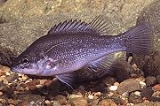
and is noted for its Bloomfield River cod
fish species, found only in the river. The river estuary is in near pristine conditions.
It was originally named "Blomfield's Rivulet" on 26 June, 1818 by Phillip Parker King It is prohibited to catch the Bloomfield river cod in Queensland.
The controversial Bloomfield Track
which connects Cape Tribulation with Cooktown
, crosses the Bloomfield River. This crossing was closed in 2011 by the Cairns Regional Council
after Cyclone Yasi
destroyed the existing causeway
. A passenger-only ferry service has been in use until a four-wheel only temporary crossing is built.
By some accounts the Cape York Peninsula
begins north of the Bloomfield River.
River
A river is a natural watercourse, usually freshwater, flowing towards an ocean, a lake, a sea, or another river. In a few cases, a river simply flows into the ground or dries up completely before reaching another body of water. Small rivers may also be called by several other names, including...
situated in Queensland
Queensland
Queensland is a state of Australia, occupying the north-eastern section of the mainland continent. It is bordered by the Northern Territory, South Australia and New South Wales to the west, south-west and south respectively. To the east, Queensland is bordered by the Coral Sea and Pacific Ocean...
, north of Daintree
Daintree, Queensland
Daintree is a settlement in North Queensland located 111 kilometres north of Cairns and 56 kilometres from Port Douglas, Queensland. The McDowell Ranges are near the town while the Daintree River flows nearby. It takes its name from Richard Daintree, a pioneering geologist of British origin in...
. The river enters the sea north of Cape Tribulation
Cape Tribulation
Cape Tribulation is a headland and locality in northern Queensland, Australia north of Cairns. It is located within the Daintree National Park and the Wet Tropics World Heritage area. At the 2006 census, Cape Tribulation had a population of 101....
and is noted for its Bloomfield River cod
Bloomfield River Cod
The Bloomfield River cod is a very small fish in the Guyu genus and the Percichthyidae family that is only found in an 11 kilometre stretch of the Bloomfield River in North Queensland, Australia...
fish species, found only in the river. The river estuary is in near pristine conditions.
It was originally named "Blomfield's Rivulet" on 26 June, 1818 by Phillip Parker King It is prohibited to catch the Bloomfield river cod in Queensland.
The controversial Bloomfield Track
Bloomfield Track
The Bloomfield Track, which is also known as the Coast Road, is a controversial four-wheel-drive road in Far North Queensland, Australia. The road's construction through untouched wilderness was the cause of protests and blockades in the early 1980s....
which connects Cape Tribulation with Cooktown
Cooktown, Queensland
Cooktown is a small town located at the mouth of the Endeavour River, on Cape York Peninsula in Far North Queensland where James Cook beached his ship, the Endeavour, for repairs in 1770. At the 2006 census, Cooktown had a population of 1,336...
, crosses the Bloomfield River. This crossing was closed in 2011 by the Cairns Regional Council
Cairns Regional Council
The Cairns Region is a Local Government Area in Far North Queensland, Queensland, Australia, centred on the regional centre of Cairns. Established in 2008, it was preceded by two previous local government areas which dated back to the 1870s....
after Cyclone Yasi
Cyclone Yasi
Severe Tropical Cyclone Yasi was a tropical cyclone that made landfall in northern Queensland, Australia in the early hours of Thursday, 3 February 2011. Yasi originated from a tropical low near Fiji. The system intensified to a Category 3 cyclone at about 5pm AEST on 31 January 2011...
destroyed the existing causeway
Causeway
In modern usage, a causeway is a road or railway elevated, usually across a broad body of water or wetland.- Etymology :When first used, the word appeared in a form such as “causey way” making clear its derivation from the earlier form “causey”. This word seems to have come from the same source by...
. A passenger-only ferry service has been in use until a four-wheel only temporary crossing is built.
By some accounts the Cape York Peninsula
Cape York Peninsula
Cape York Peninsula is a large remote peninsula located in Far North Queensland at the tip of the state of Queensland, Australia, the largest unspoilt wilderness in northern Australia and one of the last remaining wilderness areas on Earth...
begins north of the Bloomfield River.