

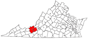
Blacksburg-Christiansburg-Radford, VA MSA
Encyclopedia
United States
The United States of America is a federal constitutional republic comprising fifty states and a federal district...
Office of Management and Budget (OMB) located in the New River Valley
New River Valley
The New River Valley is a region in the eastern United States along the New River in the Commonwealth of Virginia . The valley comprises the counties of Montgomery , Pulaski, Floyd, Giles and the independent City of Radford...
of Southwest Virginia
Virginia
The Commonwealth of Virginia , is a U.S. state on the Atlantic Coast of the Southern United States. Virginia is nicknamed the "Old Dominion" and sometimes the "Mother of Presidents" after the eight U.S. presidents born there...
. As of the 2000 census
United States Census, 2000
The Twenty-second United States Census, known as Census 2000 and conducted by the Census Bureau, determined the resident population of the United States on April 1, 2000, to be 281,421,906, an increase of 13.2% over the 248,709,873 persons enumerated during the 1990 Census...
, the MSA had a population of 151,272 (though a July 1, 2009 estimate placed the population at 159,587).
The MSA is dominated by the presence of Virginia Tech
Virginia Polytechnic Institute and State University
Virginia Polytechnic Institute and State University, popularly known as Virginia Tech , is a public land-grant university with the main campus in Blacksburg, Virginia with other research and educational centers throughout the Commonwealth of Virginia, United States, and internationally.Founded in...
and Radford University
Radford University
Radford University is one of Virginia's eight doctoral-degree granting public universities. Originally founded in 1910, Radford offers comprehensive curricula for undergraduates in more than 100 fields, and graduate programs including the M.F.A., M.B.A...
. The area, known as the New River Valley (or NRV), has experienced tremendous growth in the last twenty years and continues to be among the fastest growing areas in Virginia. It is bordered by the Allegheny Mountains to the North and the Blue Ridge Mountains to the South, with the New River flowing through the valley itself. The central communities in the area consist of two towns and one city; state law draws a sharp distinction between cities, which are completely separate from counties, and towns, which are contained within counties. Blacksburg
Blacksburg, Virginia
Blacksburg is an incorporated town located in Montgomery County, Virginia, United States, with a population of 42,620 at the 2010 census. Blacksburg, Christiansburg, and Radford are the three principal jurisdictions of the Blacksburg-Christiansburg-Radford Metropolitan Statistical Area which...
, the larger of the towns, is home to Virginia Tech, while Radford
Radford, Virginia
Radford is a city in Virginia, United States. The population was 16,408 in 2010. For statistical purposes, the Bureau of Economic Analysis combines the city of Radford with neighboring Montgomery County, including the towns of Blacksburg and Christiansburg, calling the combination the...
, the only city in the group, is home to Radford University. While Christiansburg
Christiansburg, Virginia
Christiansburg is a town in Montgomery County, Virginia, United States. The population was 21,041 at the 2010 census. It is the county seat of Montgomery County...
, a town which lies between Blacksburg and Radford in both population and geographic location, does not have an institution of higher education, it is home to hundreds of stores, restaurants, and an historic downtown.
MSA components
Note: Since a state constitutional change in 1871, all cities in VirginiaVirginia
The Commonwealth of Virginia , is a U.S. state on the Atlantic Coast of the Southern United States. Virginia is nicknamed the "Old Dominion" and sometimes the "Mother of Presidents" after the eight U.S. presidents born there...
are independent cities
Independent city
An independent city is a city that does not form part of another general-purpose local government entity. These type of cities should not be confused with city-states , which are fully sovereign cities that are not part of any other sovereign state.-Historical precursors:In the Holy Roman Empire,...
that are not located in any county. The OMB considers these independent cities to be county-equivalents for the purpose of defining MSAs in Virginia.
Three counties and one independent city are included in the Blacksburg-Christiansburg-Radford Metropolitan Statistical Area.
- Counties
- GilesGiles County, VirginiaAs of the census of 2000, there were 16,657 people, 6,994 households, and 4,888 families residing in the county. The population density was 47 people per square mile . There were 7,732 housing units at an average density of 22 per square mile...
- MontgomeryMontgomery County, VirginiaAs of the census of 2000, there were 83,629 people, 30,997 households, and 17,203 families residing in the county. The population density was 215 people per square mile . There were 32,527 housing units at an average density of 84 per square mile...
- PulaskiPulaski County, VirginiaAs of the census of 2000, there were 35,127 people, 14,643 households, and 10,147 families residing in the county. The population density was 110 people per square mile . There were 16,325 housing units at an average density of 51 per square mile...
- Giles
- Independent Cities
- RadfordRadford, VirginiaRadford is a city in Virginia, United States. The population was 16,408 in 2010. For statistical purposes, the Bureau of Economic Analysis combines the city of Radford with neighboring Montgomery County, including the towns of Blacksburg and Christiansburg, calling the combination the...
- Radford
Places with 10,000 to 20,000 inhabitants
- ChristiansburgChristiansburg, VirginiaChristiansburg is a town in Montgomery County, Virginia, United States. The population was 21,041 at the 2010 census. It is the county seat of Montgomery County...
(Principal city) - RadfordRadford, VirginiaRadford is a city in Virginia, United States. The population was 16,408 in 2010. For statistical purposes, the Bureau of Economic Analysis combines the city of Radford with neighboring Montgomery County, including the towns of Blacksburg and Christiansburg, calling the combination the...
(Principal city)
Places with 1,000 to 10,000 inhabitants
- DublinDublin, VirginiaDublin is a town in Pulaski County, Virginia, United States. The population was 2,534 at the 2010 census. It is part of the Blacksburg–Christiansburg–Radford Metropolitan Statistical Area...
- Elliston-LafayetteElliston-Lafayette, VirginiaElliston-Lafayette was a census-designated place in Montgomery County, Virginia, United States. The population was 1,241 at the 2000 census; in 2010, Elliston and Lafayette were split into separate CDPs...
(census-designated placeCensus-designated placeA census-designated place is a concentration of population identified by the United States Census Bureau for statistical purposes. CDPs are delineated for each decennial census as the statistical counterparts of incorporated places such as cities, towns and villages...
) - FairlawnFairlawn, Pulaski County, VirginiaFairlawn is a census-designated place in Pulaski County, Virginia, United States. The population was 2,211 at the 2000 census. It is served by the Radford, Virginia post office....
(census-designated place) - MerrimacMerrimac, VirginiaMerrimac is a census-designated place in Montgomery County, Virginia, United States. The population was 1,751 at the 2000 census. It is part of the Blacksburg–Christiansburg–Radford Metropolitan Statistical Area which encompasses all of Montgomery County and the city of...
(census-designated place) - NarrowsNarrows, VirginiaNarrows, named for the narrowing of the New River that flows past it, is a town in Giles County, Virginia, United States. The population was 2,111 at the 2000 census...
- PearisburgPearisburg, VirginiaPearisburg is a town in Giles County, Virginia, United States. The population was 2,729 at the 2000 census. It is the county seat of Giles County.Pearisburg is part of the Blacksburg–Christiansburg–Radford Metropolitan Statistical Area....
- PembrokePembroke, VirginiaPembroke is a town in Giles County, Virginia, United States. The population was 1,134 at the 2000 census. It is part of the Blacksburg–Christiansburg–Radford Metropolitan Statistical Area.-Geography:...
- PulaskiPulaski, VirginiaPulaski is a town in Pulaski County, Virginia, United States. The population was 9,086 at the 2010 census. It is the county seat of Pulaski County.Pulaski is part of the Blacksburg–Christiansburg–Radford Metropolitan Statistical Area.-History:...
- ShawsvilleShawsville, VirginiaShawsville is a census-designated place in Montgomery County, Virginia, United States. The population was 1,310 at the 2010 census. It is part of the Blacksburg–Christiansburg–Radford Metropolitan Statistical Area which encompasses all of Montgomery County, Virginia and the city of...
(census-designated place)
Places with fewer than 1,000 inhabitants
- Glen LynGlen Lyn, VirginiaGlen Lyn is a town in Giles County, Virginia, United States, at the confluence of the East and New Rivers. The population was 151 at the 2000 census...
- Rich CreekRich Creek, VirginiaRich Creek is a town in Giles County, Virginia, United States. The population was 665 at the 2000 census. It is part of the Blacksburg–Christiansburg–Radford Metropolitan Statistical Area.-Geography:...
Unincorporated places
|
McDonalds Mill, Virginia McDonalds Mill is an unincorporated community in the northeastern section of Montgomery County, Virginia. Located approximately 10 miles east of Blacksburg, Virginia along State Route 785, McDonalds Mill lies at the floor of the Catawba Valley and is bound on the south by Paris Mountain and to the... New River, Virginia New River is a census-designated place in Pulaski County, Virginia, United States. The population as of the 2010 Census was 244.-References:*... Prices Fork, Virginia Prices Fork is a small traditionally agricultural unincorporated community, and census-designated place , in Montgomery County, Virginia, United States. The population as of the 2010 Census was 1,066... Riner, Virginia Riner is a census-designated place in Montgomery County, Virginia. The population as of the 2010 Census was 859.... |
Rogers, Virginia Rogers is an unincorporated community in Montgomery County, Virginia, south of the county seat of Christiansburg. It is part of the Blacksburg–Christiansburg–Radford Metropolitan Statistical Area, which encompasses all of Montgomery County and the city of Radford.Rogers is located at... Sugar Grove, Montgomery County, Virginia Sugar Grove is an unincorporated community in Montgomery County, Virginia, United States. Sugar Grove is part of the Blacksburg–Christiansburg–Radford Metropolitan Statistical Area which encompasses all of Montgomery County, Virginia and the city of Radford... |
Demographics
As of the censusCensus
A census is the procedure of systematically acquiring and recording information about the members of a given population. It is a regularly occurring and official count of a particular population. The term is used mostly in connection with national population and housing censuses; other common...
of 2000, there were 151,272 people, 58,443 households, and 34,881 families residing within the MSA. The racial makeup of the MSA was 91.24% White
White American
White Americans are people of the United States who are considered or consider themselves White. The United States Census Bureau defines White people as those "having origins in any of the original peoples of Europe, the Middle East, or North Africa...
, 4.34% African American
African American
African Americans are citizens or residents of the United States who have at least partial ancestry from any of the native populations of Sub-Saharan Africa and are the direct descendants of enslaved Africans within the boundaries of the present United States...
, 0.18% Native American
Native Americans in the United States
Native Americans in the United States are the indigenous peoples in North America within the boundaries of the present-day continental United States, parts of Alaska, and the island state of Hawaii. They are composed of numerous, distinct tribes, states, and ethnic groups, many of which survive as...
, 2.44% Asian
Asian American
Asian Americans are Americans of Asian descent. The U.S. Census Bureau definition of Asians as "Asian” refers to a person having origins in any of the original peoples of the Far East, Southeast Asia, or the Indian subcontinent, including, for example, Cambodia, China, India, Indonesia, Japan,...
, 0.03% Pacific Islander
Pacific Islander American
Pacific Islander Americans, also known as Oceanian Americans, are residents of the United States with original ancestry from Oceania. They represent the smallest racial group counted in the United States census of 2000. They numbered 874,000 people or 0.3 percent of the United States population...
, 0.50% from other races, and 1.28% from two or more races
Multiracial American
Multiracial Americans, US residents who identify themselves as of "two or more races", were numbered at around 9 million, or 2.9% of the population, in the census of 2010. However there is considerable evidence that the real number is far higher. Prior to the mid-20th century many people hid their...
. Hispanics or Latinos
Hispanic and Latino Americans
Hispanic or Latino Americans are Americans with origins in the Hispanic countries of Latin America or in Spain, and in general all persons in the United States who self-identify as Hispanic or Latino.1990 Census of Population and Housing: A self-designated classification for people whose origins...
of any race were 1.29% of the population.
The median income for a household in the MSA was $31,446, and the median income for a family was $44,478. Males had a median income of $32,377 versus $22,605 for females. The per capita income
Per capita income
Per capita income or income per person is a measure of mean income within an economic aggregate, such as a country or city. It is calculated by taking a measure of all sources of income in the aggregate and dividing it by the total population...
for the MSA was $17,184.
See also
- List of U.S. Metropolitan Statistical Areas in Virginia
- Virginia census statistical areasVirginia census statistical areasThe United States Census Bureau has defined 2 Combined Statistical Areas , 11 Metropolitan Statistical Areas , and 4 Micropolitan Statistical Areas in the Commonwealth of Virginia. The following table describes these areas with the following information:*The name of the Combined Statistical Area...