

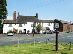
Bispham Green
Encyclopedia
West Lancashire
West Lancashire is a non-metropolitan district with the status of a borough in Lancashire, England. Its council is based in Ormskirk. The other town in the borough is Skelmersdale....
district of Lancashire
Lancashire
Lancashire is a non-metropolitan county of historic origin in the North West of England. It takes its name from the city of Lancaster, and is sometimes known as the County of Lancaster. Although Lancaster is still considered to be the county town, Lancashire County Council is based in Preston...
, England. Bispham is the civil parish
Civil parish
In England, a civil parish is a territorial designation and, where they are found, the lowest tier of local government below districts and counties...
containing the village. The village has a population of 207 (2001 Census
United Kingdom Census 2001
A nationwide census, known as Census 2001, was conducted in the United Kingdom on Sunday, 29 April 2001. This was the 20th UK Census and recorded a resident population of 58,789,194....
), and is located 1 miles (1.6 km) south of Mawdesley
Mawdesley
Mawdesley is a village and civil parish of the Borough of Chorley in Lancashire, England. According to the 2001 Census it had a population of 1,787.-History:...
and 5 miles (8 km) north of Parbold
Parbold
Parbold is a large commuter village and civil parish in the county of Lancashire, England.-Local government:The 83 hectares of the 'urban settlement' of Parbold has a population of 2,700. This settlement forms part of the larger Parbold ward Parbold is a large commuter village and civil parish in...
.
Bispham Green is one of over twenty towns and villages which, together, make up the local government district
Non-metropolitan district
Non-metropolitan districts, or colloquially shire districts, are a type of local government district in England. As created, they are sub-divisions of non-metropolitan counties in a so-called "two-tier" arrangement...
of West Lancashire. Bispham is the only parish in the West Lancashire district that is served by a parish meeting
Parish meeting
A parish meeting, in England, is a meeting to which all the electors in a civil parish are entitled to attend. In some cases, where a parish or group of parishes has fewer than 200 electors, the parish meeting can take on the role of the parish council itself, with statutory powers, and electing a...
instead of a town
Town council
A town council is a democratically elected form of government for small municipalities or civil parishes. A council may serve as both the representative and executive branch....
or parish council. The surrounding areas was once popular for osier (willow
Willow
Willows, sallows, and osiers form the genus Salix, around 400 species of deciduous trees and shrubs, found primarily on moist soils in cold and temperate regions of the Northern Hemisphere...
growing) for the basket weaving
Basket weaving
Basket weaving is the process of weaving unspun vegetable fibres into a basket or other similar form. People and artists who weave baskets are called basketmakers and basket weavers.Basketry is made from a variety of fibrous or pliable materials•anything that will bend and form a shape...
trade, but since the 1950s the land has reverted solely to agricultural use. There are no industrial buildings and no future planning for any extensive development.
Geography
Bispham is south of CrostonCroston
-External links:**** chorley.gov.uk....
, Mawdesley
Mawdesley
Mawdesley is a village and civil parish of the Borough of Chorley in Lancashire, England. According to the 2001 Census it had a population of 1,787.-History:...
and Tarleton
Tarleton
-Population :-Economy:As a result of soil on the former mossland, a major economic activity in Tarleton is market gardening, particularly growing salad crops....
, north of Hilldale and Parbold
Parbold
Parbold is a large commuter village and civil parish in the county of Lancashire, England.-Local government:The 83 hectares of the 'urban settlement' of Parbold has a population of 2,700. This settlement forms part of the larger Parbold ward Parbold is a large commuter village and civil parish in...
, west of Heskin
Heskin
Heskin is a small village and civil parish of the Borough of Chorley in Lancashire, England. According to the United Kingdom Census 2001 it has a population of 883.-Heskin Hall:Heskin Hall dates back to 1548...
, Wrightington
Wrightington
Wrightington is a civil parish in West Lancashire, England, with an area of 3,915½ acres. The surface is hilly, rising to over 400 ft. at Harrock on the border of Parbold, and then falling to the north, north-east and south-east. On the southern border, the boundary at Appley Bridge touches...
and Eccleston
Eccleston, Lancashire
-Mr.Asia's Murder:Christopher Marty Johnstone was a New Zealand drug trafficker. The former Takapuna Grammar pupil was dubbed "Mr Asia" by the Auckland Star newspaper in August 1978 in a series of articles by Pat Booth....
. The River Douglas
River Douglas
The River Douglas, also known as the River Asland or Astland, is a river that flows through Lancashire and Greater Manchester in the north-west of England...
travels through Bispham and it is a tributary to the River Ribble
River Ribble
The River Ribble is a river that runs through North Yorkshire and Lancashire, in northern England. The river's drainage basin also includes parts of Greater Manchester around Wigan.-Geography:...
and has two tributaries itself, the River Tawd
River Tawd
The River Tawd flows through Skelmersdale and Lathom in West Lancashire.The Tawd Bridge carried Ormskirk Road, the main arterial road from Wigan to Ormskirk and Southport. This is well-known to Upholland locals as the place where highwayman George Lyons held up his victims during the 18th century....
and the River Yarrow
River Yarrow (Lancashire)
The River Yarrow is in Lancashire, with its source at an area called Will Narr at Hordern Stoops, along Spitlers Edge - the Chorley/Blackburn boundary - on the West Pennine Moors. The river feeds the Yarrow Reservoir, which in turn feeds the Anglezarke and Upper and Lower Rivington Reservoirs...
. It shares its local parish with Mawdesley as Bispham has no actual churches on its land. The land around Bispham is both pastoral
Pastoral
The adjective pastoral refers to the lifestyle of pastoralists, such as shepherds herding livestock around open areas of land according to seasons and the changing availability of water and pasturage. It also refers to a genre in literature, art or music that depicts such shepherd life in an...
and arable
Arable land
In geography and agriculture, arable land is land that can be used for growing crops. It includes all land under temporary crops , temporary meadows for mowing or pasture, land under market and kitchen gardens and land temporarily fallow...
and abundant with wildlife. Bispham covers an area of approximately 1000 acres (4 km²) of grade 2 agricultural land. Rising to 80 metres above sea level at its eastern tip, it is bounded on the south side of the River Douglas
River Douglas
The River Douglas, also known as the River Asland or Astland, is a river that flows through Lancashire and Greater Manchester in the north-west of England...
, and on the north side of Bentley Brook.
Richard Durning's Endowed Primary School
It was known as Bispham Free Grammar School up until 1951. The name was changed to Richard Durning's because Richard Durning himself had funded the building of the school in his will after he died in 1692. He had set aside £100 for the school and the land (known as Higher Jacks field) was purchased for £10. He also left money of which "a yearly sum of £4 is to be paid to four or six poor people of Bispham such as by age, sickness, lameness, or any other infirmity should have need, (bastards always excepted) £2 for repairing the high lanes of Bispham Green and Grimshaw Green and the house of Peter Travis, and the high lanes of Wrightington, £5 for the binding of poor children apprentices in the townships of Bispham, Parbold, Mawdesley and Wrightington, £5 to be paid and distributed among two or more of my poor kindred, £2 towards the support of a preaching minister at Douglas Chapel.” Today the Trustees of the Charity administer its assets, the income from which is used to provide special benefits to the school and to award grants towards the cost of the education and training of young people under the age of 25 who are pupils or former pupils of the school or who reside in the civil parishes of Bispham, Parbold, Mawdesley, Wrightington and Croston. Part of the school building dates back to 1693. It is located on Chorley Road, in Bispham. Richard Durning was a local yeomanYeoman
Yeoman refers chiefly to a free man owning his own farm, especially from the Elizabethan era to the 17th century. Work requiring a great deal of effort or labor, such as would be done by a yeoman farmer, came to be described as "yeoman's work"...
, who was born in 1615 and died in 1692 at the age of 75. He is buried in the Chancel of St Michael an All Angels Parish Church in Croston.