Big Bay Dam
Encyclopedia
Purvis, Mississippi
Purvis is a city in Lamar County, Mississippi, United States. It is part of the Hattiesburg, Mississippi Metropolitan Statistical Area. The population was 2,164 at the 2000 census. It is the county seat of Lamar County. The Town of Purvis was incorporated on February 25, 1888 and was founded by...
in Lamar County
Lamar County, Mississippi
-Demographics:As of the census of 2000, there were 39,070 people, 14,396 households, and 10,725 families residing in the county. The population density was 79 people per square mile . There were 15,433 housing units at an average density of 31 per square mile...
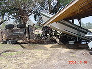
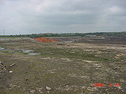
. On March 12, 2004 the Big Bay dam embankment failed though piping in the vicinity of the principal spillway 12 years after construction. A peak breach flow of 147,000 ft3/s (4,200 m3/s) was estimated from the breach geometry, breach timing and the reservoir volume . The Big Bay embankment, which is largely intact, is approximately 1890 feet long and 51.3 feet high. The failure occurred with an initial water surface about 6 inches (0.15 m) above the normal pool elevation of 278.0 ft (84.73 m), releasing 14,200 ac-ft (17,500,000 m3) of water and inundating 14.3 miles (23.0 km) of valley to depths of up to 33 ft (10 m) from the dam to the Pearl River. Woody material was stripped from the stream valley for a length of 2300 ft (700 m) immediately below the dam, after which velocities decreased to such an extent that little vegetation was uprooted.
The inundation impacted Bay Creek and Lower Little Creek in Lamar and Marion
Marion, Mississippi
Marion is a town in Lauderdale County, Mississippi, United States. The population was 1,305 at the 2000 census.-Geography:Marion is located at ....
Counties. A damage assessment indicated that, within Lamar County, 26 homes were destroyed, 8 homes had major damage, 8 homes had minor damage, 25 mobile homes were destroyed and 1 mobile home had minor damage. In Marion County, 1 home was destroyed, 13 homes had major damage, 12 homes had minor damage, 1 mobile home was destroyed, 3 mobile homes had major damage, 3 mobile homes had minor damage, Pine Burr Church suffered major damage, Hub Chapel Church had minor damage, and the Pinebur Volunteer Fire Department suffered major damage. In all, 104 structures were documented as damaged or destroyed. No human lives were lost.
The dam breach characteristics, specifically the breach geometry and formation time, were estimated by Yochum et al. 2008. The breach width was measured to be 230 ft (70 m), with a top width of 315 ft (96 m), right side slope of 0.61 and a left side slope of 1.3 (horizontal/vertical). In regard to the breach timing, increased discharge from a pre-existing seep was first noticed on Thursday, March 11 . The seep gradually increased its discharge, with the flow carrying material by the next morning. At mid-morning on March 12 the seep was inspected and was noticed that it had about a ½ inch of head height. By 12:15 water “shot up out of the hole”. Shortly after this the seep was observed to be “spouting approximately 2 to 3 ft in height, with a diameter of about 18 inches”. The area around the boil then collapsed and the embankment began to rapidly erode. This is the point where the breach is assumed to start, at about 12:20. The final breach dimensions occurred from about 13:10. Full formation is assumed to occur at 13:15—the breach formation time is estimated to be 55 minutes.