
Bicycle Path
Encyclopedia
Bicycle Path is a historic road in Central Suffolk County on Long Island, New York, built in the late 19th Century in order to capitalize on the bicycle craze of that period. It ran north and south from Patchogue to just east of Port Jefferson
, lying mostly west of New York State Route 112
, crossing it at Port Jefferson Road in Port Jefferson Station.
Beginning in Patchogue at what is today the intersection of East Main Street
and NY 112
, the road survives as Medford Avenue which was widened to four lanes from East Main Street to Clark Street in 1964, then to five lanes north of the vicinity of the interchange with Sunrise Highway
.
In North Patchogue
, near Shaber Road, Route 112 moves to the northeast onto Port Jefferson-Patchogue Highway, while the original Bicycle Path goes straight north from Medford Avenue to Old Medford Avenue.
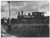
 Near the Main Line of the Long Island Rail Road
in Medford, Bicycle Path used to climb over a narrow wooden grade crossing. The crossing was replaced by a bridge in 1907. As Old Medford Avenue crosses under the Long Island Expressway
, it leaves Medford
and enters Farmingville
, where it enters a residential area north of Suffolk CR 16(Horse Block Road)
.
North of Granny Road, Old Medford Avenue ends, and the remnants of the original name of the road is exposed, as South Bicycle Path. This road winds through the legendary steep hills of Farmingville and Selden
, past an area which later in the 20th Century included the Bald Hill Ski Bowl until 1980. An interchange was built over the road for an extension of Suffolk CR 83
known as Patchogue-Mount Sinai Road in the early 1960s, but the road itself wasn't built until 1972.
Currently, South Bicycle Path terminates at a cul-de-sac
north of Ormond Avenue in Selden. At that point, the road originally cut across a southeast-to-northwest trail across NY 25
, but this section south of NY 25 was closed in 1932. A hotel built along NY 25 west of Adirondack Drive known as Norton's Wheelman's Rest was designed to accommodate bicycle riders, but left to deteriorate later in the 20th Century. The property where the hotel once stood is now a row of batting cages.
Bicycle Path resumes north of NY 25
in Selden as North Bicycle Path, however the original intersection was replaced with a branch of the Middle Country Library. The current intersection takes a jughandle
around this building and intersects with the original road in front of an elementary school, then heads north through a residential area.
Somewhere north of Old Town Road, North Bicycle Path loses its "North" designation. The current terminus of Bicycle Path is as NY 112 south of Port Jefferson Station, however the road originally went further north than that. According to some maps, the northern terminus was north of Canal Road, where it entered a local race track and was proposed to be extended into Crystal Brook Hollow Road, where it would end somewhere along the western edge of Mount Sinai Harbor.
Port Jefferson, New York
The Incorporated Village of Port Jefferson is located in the town of Brookhaven in Suffolk County, New York on the North Shore of Long Island. As of the 2000 United States Census, the village population was 7,837...
, lying mostly west of New York State Route 112
New York State Route 112
New York State Route 112 is a New York state highway, entirely within the Town of Brookhaven in Suffolk County. It runs from Montauk Highway, formerly part of NY 27A, in the village of Patchogue to NY 25A in Port Jefferson Station. It is known locally as Medford Ave in Patchogue...
, crossing it at Port Jefferson Road in Port Jefferson Station.
Beginning in Patchogue at what is today the intersection of East Main Street
Montauk Highway
Montauk Highway is one of the original through highways of Long Island, New York, extending from Jamaica, in the New York City borough of Queens to Montauk Point in Suffolk County, a distance of approximately 100 miles ....
and NY 112
New York State Route 112
New York State Route 112 is a New York state highway, entirely within the Town of Brookhaven in Suffolk County. It runs from Montauk Highway, formerly part of NY 27A, in the village of Patchogue to NY 25A in Port Jefferson Station. It is known locally as Medford Ave in Patchogue...
, the road survives as Medford Avenue which was widened to four lanes from East Main Street to Clark Street in 1964, then to five lanes north of the vicinity of the interchange with Sunrise Highway
New York State Route 27
New York State Route 27 is an east–west long state highway extending from Interstate 278 in the New York City borough of Brooklyn to Montauk Point State Park on Long Island, New York, United States...
.
In North Patchogue
North Patchogue, New York
North Patchogue is a census-designated place in Suffolk County, New York, United States. The population was 7,825 at the 2000 census. The community is located on Long Island.-Geography:North Patchogue is located at ....
, near Shaber Road, Route 112 moves to the northeast onto Port Jefferson-Patchogue Highway, while the original Bicycle Path goes straight north from Medford Avenue to Old Medford Avenue.
Main Line (Long Island Rail Road)
The Main Line is a rail line owned and operated by the Long Island Rail Road in the U.S. state of New York. It begins in Long Island City and runs along the middle of Long Island about 95 miles to Greenport...
in Medford, Bicycle Path used to climb over a narrow wooden grade crossing. The crossing was replaced by a bridge in 1907. As Old Medford Avenue crosses under the Long Island Expressway
Interstate 495 (New York)
Interstate 495 is an auxiliary Interstate Highway on Long Island in New York in the United States. The route extends for from the western portal of the Queens-Midtown Tunnel in the New York City borough of Manhattan to County Route 58 in Riverhead, Suffolk County...
, it leaves Medford
Medford, New York
Medford is a hamlet in Suffolk County, New York, United States. The population was 21,985 at the 2000 census.Medford is a community in the southwest part of the Town of Brookhaven...
and enters Farmingville
Farmingville, New York
Farmingville is a hamlet in Suffolk County, New York, United States. The population was 16,458 at the 2000 census.Farmingville is in the Town of Brookhaven...
, where it enters a residential area north of Suffolk CR 16(Horse Block Road)
County Route 16 (Suffolk County, New York)
Suffolk County Route 16 is a main thoroughfare through central Suffolk County, New York. Its western terminus is at Middle Country Road in Smithtown, on the eastern border of the Village of the Branch, and its eastern terminus is at Montauk Highway in Brookhaven near Southhaven...
.
North of Granny Road, Old Medford Avenue ends, and the remnants of the original name of the road is exposed, as South Bicycle Path. This road winds through the legendary steep hills of Farmingville and Selden
Selden, New York
Selden is a hamlet in the town of Brookhaven in Suffolk County, New York, United States. The population was 21,861 at the 2000 census.-Early Settlement:...
, past an area which later in the 20th Century included the Bald Hill Ski Bowl until 1980. An interchange was built over the road for an extension of Suffolk CR 83
County Route 83 (Suffolk County, New York)
Suffolk County Road 83 is a major county road in Suffolk County, New York. It runs north and south from New York State Route 27 at exit 52A in North Patchogue to New York State Route 25A in Mount Sinai...
known as Patchogue-Mount Sinai Road in the early 1960s, but the road itself wasn't built until 1972.
Currently, South Bicycle Path terminates at a cul-de-sac
Cul-de-sac
A cul-de-sac is a word of French origin referring to a dead end, close, no through road or court meaning dead-end street with only one inlet/outlet...
north of Ormond Avenue in Selden. At that point, the road originally cut across a southeast-to-northwest trail across NY 25
New York State Route 25
New York State Route 25 is an east–west state highway in downstate New York in the United States. The route extends for just over from east midtown Manhattan in New York City to the Cross Sound Ferry terminal at Orient Point on the end of Long Island's North Fork...
, but this section south of NY 25 was closed in 1932. A hotel built along NY 25 west of Adirondack Drive known as Norton's Wheelman's Rest was designed to accommodate bicycle riders, but left to deteriorate later in the 20th Century. The property where the hotel once stood is now a row of batting cages.
Bicycle Path resumes north of NY 25
New York State Route 25
New York State Route 25 is an east–west state highway in downstate New York in the United States. The route extends for just over from east midtown Manhattan in New York City to the Cross Sound Ferry terminal at Orient Point on the end of Long Island's North Fork...
in Selden as North Bicycle Path, however the original intersection was replaced with a branch of the Middle Country Library. The current intersection takes a jughandle
Jughandle
A jughandle is a type of ramp or slip road that changes the way traffic turns left at at-grade intersections. Instead of a standard left turn being made from the left lane, left-turning traffic uses a ramp on the right side of the road...
around this building and intersects with the original road in front of an elementary school, then heads north through a residential area.
Somewhere north of Old Town Road, North Bicycle Path loses its "North" designation. The current terminus of Bicycle Path is as NY 112 south of Port Jefferson Station, however the road originally went further north than that. According to some maps, the northern terminus was north of Canal Road, where it entered a local race track and was proposed to be extended into Crystal Brook Hollow Road, where it would end somewhere along the western edge of Mount Sinai Harbor.
Resources
- Old Hagstroms Maps and atlases.
- Suffolk County Historical Society
- Old Medford Avenue Railroad Bridge(c. 1987)