
Betancuria
Encyclopedia
 |
Fuerteventura
Fuerteventura , a Spanish island, is one of the Canary Islands, in the Atlantic Ocean off the coast of Africa. It is situated at 28°20' north, 14°00' west. At 1,660 km² it is the second largest of the Canary Islands, after Tenerife...
in the Spanish
Spain
Spain , officially the Kingdom of Spain languages]] under the European Charter for Regional or Minority Languages. In each of these, Spain's official name is as follows:;;;;;;), is a country and member state of the European Union located in southwestern Europe on the Iberian Peninsula...
province of Las Palmas
Las Palmas (province)
The Province of Las Palmas is a province of Spain, consisting of the eastern part of the autonomous community of the Canary Islands.-Composition:...
, Canary Islands
Canary Islands
The Canary Islands , also known as the Canaries , is a Spanish archipelago located just off the northwest coast of mainland Africa, 100 km west of the border between Morocco and the Western Sahara. The Canaries are a Spanish autonomous community and an outermost region of the European Union...
.
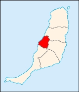
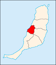
The population is 721 (ISTAC, 2003), its density is 6.96/km² and is excepted to reach 100/km² and the area is 103.64 km². The population is the smallest in Fuerteventura as well as the province of Las Palmas and all of the Canary Islands. The city of Betancuria is named after Jean de Béthencourt
Jean de Béthencourt
Jean de Béthencourt was a French explorer who, in 1402, led an expedition to the Canary Islands, landing first on the north side of Lanzarote...
and was founded in 1404 by Gadifer de La Salle
Gadifer de la Salle
Gadifer de La Salle was a French knight and crusader of Poitevine origin who, with Jean de Béthencourt, conquered and explored the Canary Islands for the Kingdom of Castile....
and Jean de Béthencourt and was the main city in the central part of the island until the 19th century. It is located a main highway linking north to Puerto del Rosario
Puerto del Rosario
Puerto del Rosario is a Canarian municipality in the northern portion of the island of Fuerteventura in the Las Palmas province in the Canary Islands. Puerto del Rosario is also the capital of the island of Fuerteventura since 1835. The population is 28,357 , with a density of 39.43/km² which is...
and Tuineje and another east to Antigua
Antigua, Fuerteventura
Antigua is a Canarian municipality in the central and the eastern portion of the island of Fuerteventura in the Las Palmas province in the Canary Islands The population is 6,587 , its density is 26.29/km² and the area is 250.56 km². It is located a main highway linking north to Puerto del Rosario...
. The main industries are agriculture and tourism. The Atlantic Ocean
Atlantic Ocean
The Atlantic Ocean is the second-largest of the world's oceanic divisions. With a total area of about , it covers approximately 20% of the Earth's surface and about 26% of its water surface area...
is to the west, the mountains cover much of the municipality along with barren land. Farmlands dominate the rest of the municipality.
Betancuria was sacked by pirates in older times. The island's capital moved to Antigua
Antigua, Fuerteventura
Antigua is a Canarian municipality in the central and the eastern portion of the island of Fuerteventura in the Las Palmas province in the Canary Islands The population is 6,587 , its density is 26.29/km² and the area is 250.56 km². It is located a main highway linking north to Puerto del Rosario...
in 1834 before moving to the present capital of Puerto del Rosario.
Geography
- Location:
- Latitude: 28.41667 (28°25') N
- Longitude: 14.05 (14°3') W
- Altitude:
- Lowest: Atlantic Ocean
- Centre: 395 m
- Highest: central part
- Name of inhabitants: Betancurian sing., -s pl.
- Postal code: 35637
Other
Betancuria has a school, a small lyceum, a few gymnasia, a few churches, beaches, a post office, and a square (plaza).See also
- List of municipalities in Las Palmas
North: Puerto del Rosario Puerto del RosarioPuerto del Rosario is a Canarian municipality in the northern portion of the island of Fuerteventura in the Las Palmas province in the Canary Islands. Puerto del Rosario is also the capital of the island of Fuerteventura since 1835. The population is 28,357 , with a density of 39.43/km² which is...West: Atlantic Ocean Puerto del Rosario East: Antigua South: Pájara