
Bennington, New Hampshire
Encyclopedia
Bennington is a town in Hillsborough County
, New Hampshire
, United States
. The population was 1,476 at the 2010 census.
The main village of the town, where 381 people resided at the 2010 census, is defined as the Bennington census-designated place
(CDP), and is located on the Contoocook River
at the intersection of New Hampshire routes 31
and 47
.
, Francestown
, Greenfield
and Hancock
. It was named to commemorate the 1777 Battle of Bennington
, a three-day battle fought in New York
near Bennington, Vermont
. Bennington, Vermont in turn derived its name from colonial governor Benning Wentworth
. The town was incorporated in 1842. The first census, taken in 1850, recorded 541 residents.
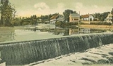
Located at the Great Falls of the Contoocook River
, which drop 70 feet (21.3 m) over 1.2 miles (1.9 km), Bennington provided water power for mills
. The first gristmill
was built in 1782, with a cotton
mill in 1810. A tannery
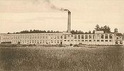
and tool manufacturing industry would follow. A factory with paper-making
machinery was established in 1835, located at or near the site of the present-day Monadnock Paper Mill. In 1858, the town's industries included a cutlery
manufacturer, a gristmill, 2 paper mills and a sawmill
. Bennington also had quite a number of farm
s.
, the town has a total area of 11.3 square miles (29.3 km²), of which 11.1 sq mi (28.7 km²) is land and 0.3 sq mi (0.776996433 km²) is water, comprising 2.30% of the town. Bennington is drained by the Contoocook River
, which forms Powder Mill Pond
on the southern boundary. The highest point in Bennington is 2020 feet (615.7 m) above sea level
on Crotched Mountain, whose 2066 feet (629.7 m) summit lies just east in Francestown
. Bennington lies fully within the Merrimack River
watershed
.
and 47
. It borders the towns of Deering
to the northeast, Francestown
to the east, Greenfield
to the south, Hancock
to the southwest, and Antrim
to the west and north.
 As of the census
of 2000, there were 1,401 people, 552 households, and 356 families residing in the town. The population density
was 126.7 people per square mile (48.9/km²). There were 635 housing units at an average density of 57.4 per square mile (22.2/km²). The racial makeup of the town was 98.00% White, 0.07% African American, 0.14% Native American, 0.29% Asian, 0.07% Pacific Islander, 0.21% from other races
, and 1.21% from two or more races. Hispanic or Latino of any race were 0.64% of the population.
There were 552 households out of which 34.1% had children under the age of 18 living with them, 52.0% were married couples
living together, 8.0% had a female householder with no husband present, and 35.5% were non-families. 26.8% of all households were made up of individuals and 5.4% had someone living alone who was 65 years of age or older. The average household size was 2.54 and the average family size was 3.18.
 In the town the population was spread out with 28.6% under the age of 18, 7.0% from 18 to 24, 33.5% from 25 to 44, 22.8% from 45 to 64, and 8.1% who were 65 years of age or older. The median age was 35 years. For every 100 females there were 97.6 males. For every 100 females age 18 and over, there were 99.8 males.
The median income for a household in the town was $46,150, and the median income for a family was $52,153. Males had a median income of $34,063 versus $26,734 for females. The per capita income
for the town was $19,675. About 8.4% of families and 7.9% of the population were below the poverty line, including 10.3% of those under age 18 and 13.2% of those age 65 or over.
Hillsborough County, New Hampshire
-Demographics:As of the census of 2000, there were 380,841 people, 144,455 households, and 98,807 families residing in the county. The population density was 435 people per square mile . There were 149,961 housing units at an average density of 171 per square mile...
, New Hampshire
New Hampshire
New Hampshire is a state in the New England region of the northeastern United States of America. The state was named after the southern English county of Hampshire. It is bordered by Massachusetts to the south, Vermont to the west, Maine and the Atlantic Ocean to the east, and the Canadian...
, United States
United States
The United States of America is a federal constitutional republic comprising fifty states and a federal district...
. The population was 1,476 at the 2010 census.
The main village of the town, where 381 people resided at the 2010 census, is defined as the Bennington census-designated place
Census-designated place
A census-designated place is a concentration of population identified by the United States Census Bureau for statistical purposes. CDPs are delineated for each decennial census as the statistical counterparts of incorporated places such as cities, towns and villages...
(CDP), and is located on the Contoocook River
Contoocook River
The Contoocook River is a river in New Hampshire. It flows from Pool Pond and Contoocook Lake on the Jaffrey/Rindge border to Penacook , where it empties into the Merrimack River. It is one of only a few rivers in New Hampshire that flow in a predominantly northward direction...
at the intersection of New Hampshire routes 31
New Hampshire Route 31
New Hampshire Route 31 is a long north–south state highway in southern New Hampshire. It runs from Mason on the Massachusetts border to Goshen....
and 47
New Hampshire Route 47
New Hampshire Route 47 is a 7.10 east–west highway in southern New Hampshire. It runs from Francestown to Bennington.The western terminus of NH 47 is in Bennington at U.S. Route 202...
.
History
Situated in an area once called Society Land, the town was formed from parts of DeeringDeering, New Hampshire
Deering is a town in Hillsborough County, New Hampshire, United States. The population was 1,912 at the 2010 census.-History:First settled about 1765, the town was incorporated on January 17, 1774 by John Wentworth, governor of the province of New Hampshire...
, Francestown
Francestown, New Hampshire
Francestown is a town in Hillsborough County, New Hampshire, United States. The population was 1,562 at the 2010 census.- History :Incorporated in 1772, Francestown takes its name from Frances Deering Wentworth, the wife of colonial governor John Wentworth. There were 928 residents when the first...
, Greenfield
Greenfield, New Hampshire
Greenfield is a town in Hillsborough County, New Hampshire, United States. The population was 1,749 at the 2010 census. Greenfield is home to the Crotched Mountain Rehabilitation Center, to Greenfield State Park, and to part of the Wapack Trail.- History :...
and Hancock
Hancock, New Hampshire
Hancock is a town in Hillsborough County, New Hampshire, United States. The population was 1,654 at the 2010 census. Hancock is home to the Welch Family Farm Forest....
. It was named to commemorate the 1777 Battle of Bennington
Battle of Bennington
The Battle of Bennington was a battle of the American Revolutionary War that took place on August 16, 1777, in Walloomsac, New York, about from its namesake Bennington, Vermont...
, a three-day battle fought in New York
New York
New York is a state in the Northeastern region of the United States. It is the nation's third most populous state. New York is bordered by New Jersey and Pennsylvania to the south, and by Connecticut, Massachusetts and Vermont to the east...
near Bennington, Vermont
Vermont
Vermont is a state in the New England region of the northeastern United States of America. The state ranks 43rd in land area, , and 45th in total area. Its population according to the 2010 census, 630,337, is the second smallest in the country, larger only than Wyoming. It is the only New England...
. Bennington, Vermont in turn derived its name from colonial governor Benning Wentworth
Benning Wentworth
Benning Wentworth was the colonial governor of New Hampshire from 1741 to 1766.-Biography:The eldest child of the John Wentworth who had been Lieutenant Governor, he was born and died in Portsmouth, New Hampshire. Wentworth graduated from Harvard College in 1715...
. The town was incorporated in 1842. The first census, taken in 1850, recorded 541 residents.
Located at the Great Falls of the Contoocook River
Contoocook River
The Contoocook River is a river in New Hampshire. It flows from Pool Pond and Contoocook Lake on the Jaffrey/Rindge border to Penacook , where it empties into the Merrimack River. It is one of only a few rivers in New Hampshire that flow in a predominantly northward direction...
, which drop 70 feet (21.3 m) over 1.2 miles (1.9 km), Bennington provided water power for mills
Watermill
A watermill is a structure that uses a water wheel or turbine to drive a mechanical process such as flour, lumber or textile production, or metal shaping .- History :...
. The first gristmill
Gristmill
The terms gristmill or grist mill can refer either to a building in which grain is ground into flour, or to the grinding mechanism itself.- Early history :...
was built in 1782, with a cotton
Cotton
Cotton is a soft, fluffy staple fiber that grows in a boll, or protective capsule, around the seeds of cotton plants of the genus Gossypium. The fiber is almost pure cellulose. The botanical purpose of cotton fiber is to aid in seed dispersal....
mill in 1810. A tannery
Tanning
Tanning is the making of leather from the skins of animals which does not easily decompose. Traditionally, tanning used tannin, an acidic chemical compound from which the tanning process draws its name . Coloring may occur during tanning...
and tool manufacturing industry would follow. A factory with paper-making
Paper mill
A paper mill is a factory devoted to making paper from vegetable fibres such as wood pulp, old rags and other ingredients using a Fourdrinier machine or other type of paper machine.- History :...
machinery was established in 1835, located at or near the site of the present-day Monadnock Paper Mill. In 1858, the town's industries included a cutlery
Cutlery
Cutlery refers to any hand implement used in preparing, serving, and especially eating food in the Western world. It is more usually known as silverware or flatware in the United States, where cutlery can have the more specific meaning of knives and other cutting instruments. This is probably the...
manufacturer, a gristmill, 2 paper mills and a sawmill
Sawmill
A sawmill is a facility where logs are cut into boards.-Sawmill process:A sawmill's basic operation is much like those of hundreds of years ago; a log enters on one end and dimensional lumber exits on the other end....
. Bennington also had quite a number of farm
Farm
A farm is an area of land, or, for aquaculture, lake, river or sea, including various structures, devoted primarily to the practice of producing and managing food , fibres and, increasingly, fuel. It is the basic production facility in food production. Farms may be owned and operated by a single...
s.
Geography
According to the United States Census BureauUnited States Census Bureau
The United States Census Bureau is the government agency that is responsible for the United States Census. It also gathers other national demographic and economic data...
, the town has a total area of 11.3 square miles (29.3 km²), of which 11.1 sq mi (28.7 km²) is land and 0.3 sq mi (0.776996433 km²) is water, comprising 2.30% of the town. Bennington is drained by the Contoocook River
Contoocook River
The Contoocook River is a river in New Hampshire. It flows from Pool Pond and Contoocook Lake on the Jaffrey/Rindge border to Penacook , where it empties into the Merrimack River. It is one of only a few rivers in New Hampshire that flow in a predominantly northward direction...
, which forms Powder Mill Pond
Powder Mill Pond
Powder Mill Pond is a impoundment on the Contoocook River in Hillsborough County in southern New Hampshire, United States. The pond's dam is located in the town of Bennington, with water impounded into the towns of Hancock and Greenfield....
on the southern boundary. The highest point in Bennington is 2020 feet (615.7 m) above sea level
Sea level
Mean sea level is a measure of the average height of the ocean's surface ; used as a standard in reckoning land elevation...
on Crotched Mountain, whose 2066 feet (629.7 m) summit lies just east in Francestown
Francestown, New Hampshire
Francestown is a town in Hillsborough County, New Hampshire, United States. The population was 1,562 at the 2010 census.- History :Incorporated in 1772, Francestown takes its name from Frances Deering Wentworth, the wife of colonial governor John Wentworth. There were 928 residents when the first...
. Bennington lies fully within the Merrimack River
Merrimack River
The Merrimack River is a river in the northeastern United States. It rises at the confluence of the Pemigewasset and Winnipesaukee rivers in Franklin, New Hampshire, flows southward into Massachusetts, and then flows northeast until it empties into the Atlantic Ocean at Newburyport...
watershed
Drainage basin
A drainage basin is an extent or an area of land where surface water from rain and melting snow or ice converges to a single point, usually the exit of the basin, where the waters join another waterbody, such as a river, lake, reservoir, estuary, wetland, sea, or ocean...
.
Transportation
The town is crossed by U. S. Route 202 and state routes 31New Hampshire Route 31
New Hampshire Route 31 is a long north–south state highway in southern New Hampshire. It runs from Mason on the Massachusetts border to Goshen....
and 47
New Hampshire Route 47
New Hampshire Route 47 is a 7.10 east–west highway in southern New Hampshire. It runs from Francestown to Bennington.The western terminus of NH 47 is in Bennington at U.S. Route 202...
. It borders the towns of Deering
Deering, New Hampshire
Deering is a town in Hillsborough County, New Hampshire, United States. The population was 1,912 at the 2010 census.-History:First settled about 1765, the town was incorporated on January 17, 1774 by John Wentworth, governor of the province of New Hampshire...
to the northeast, Francestown
Francestown, New Hampshire
Francestown is a town in Hillsborough County, New Hampshire, United States. The population was 1,562 at the 2010 census.- History :Incorporated in 1772, Francestown takes its name from Frances Deering Wentworth, the wife of colonial governor John Wentworth. There were 928 residents when the first...
to the east, Greenfield
Greenfield, New Hampshire
Greenfield is a town in Hillsborough County, New Hampshire, United States. The population was 1,749 at the 2010 census. Greenfield is home to the Crotched Mountain Rehabilitation Center, to Greenfield State Park, and to part of the Wapack Trail.- History :...
to the south, Hancock
Hancock, New Hampshire
Hancock is a town in Hillsborough County, New Hampshire, United States. The population was 1,654 at the 2010 census. Hancock is home to the Welch Family Farm Forest....
to the southwest, and Antrim
Antrim, New Hampshire
Antrim is a town in Hillsborough County, New Hampshire, United States. The population was 2,637 at the 2010 census. The primary settlement in the town, where 1,397 people resided at the 2010 census, is defined as the Antrim census-designated place and is located at the intersection of U.S. Route...
to the west and north.
Demographics
Census
A census is the procedure of systematically acquiring and recording information about the members of a given population. It is a regularly occurring and official count of a particular population. The term is used mostly in connection with national population and housing censuses; other common...
of 2000, there were 1,401 people, 552 households, and 356 families residing in the town. The population density
Population density
Population density is a measurement of population per unit area or unit volume. It is frequently applied to living organisms, and particularly to humans...
was 126.7 people per square mile (48.9/km²). There were 635 housing units at an average density of 57.4 per square mile (22.2/km²). The racial makeup of the town was 98.00% White, 0.07% African American, 0.14% Native American, 0.29% Asian, 0.07% Pacific Islander, 0.21% from other races
Race (United States Census)
Race and ethnicity in the United States Census, as defined by the Federal Office of Management and Budget and the United States Census Bureau, are self-identification data items in which residents choose the race or races with which they most closely identify, and indicate whether or not they are...
, and 1.21% from two or more races. Hispanic or Latino of any race were 0.64% of the population.
There were 552 households out of which 34.1% had children under the age of 18 living with them, 52.0% were married couples
Marriage
Marriage is a social union or legal contract between people that creates kinship. It is an institution in which interpersonal relationships, usually intimate and sexual, are acknowledged in a variety of ways, depending on the culture or subculture in which it is found...
living together, 8.0% had a female householder with no husband present, and 35.5% were non-families. 26.8% of all households were made up of individuals and 5.4% had someone living alone who was 65 years of age or older. The average household size was 2.54 and the average family size was 3.18.
The median income for a household in the town was $46,150, and the median income for a family was $52,153. Males had a median income of $34,063 versus $26,734 for females. The per capita income
Per capita income
Per capita income or income per person is a measure of mean income within an economic aggregate, such as a country or city. It is calculated by taking a measure of all sources of income in the aggregate and dividing it by the total population...
for the town was $19,675. About 8.4% of families and 7.9% of the population were below the poverty line, including 10.3% of those under age 18 and 13.2% of those age 65 or over.