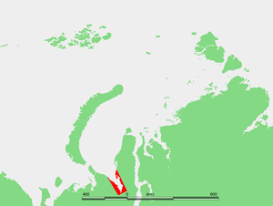
Baydaratskaya Bay
Encyclopedia

Headlands and bays
Headlands and bays are two related features of the coastal environment.- Geology and geography :Headlands and bays are often found on the same coastline. A bay is surrounded by land on three sides, whereas a headland is surrounded by water on three sides. Headlands are characterized by high,...
in Russia
Russia
Russia or , officially known as both Russia and the Russian Federation , is a country in northern Eurasia. It is a federal semi-presidential republic, comprising 83 federal subjects...
, located in the southern part of the Kara Sea
Kara Sea
The Kara Sea is part of the Arctic Ocean north of Siberia. It is separated from the Barents Sea to the west by the Kara Strait and Novaya Zemlya, and the Laptev Sea to the east by the Severnaya Zemlya....
between the coastline of the Northern termination of the Ural Mountains
Ural Mountains
The Ural Mountains , or simply the Urals, are a mountain range that runs approximately from north to south through western Russia, from the coast of the Arctic Ocean to the Ural River and northwestern Kazakhstan. Their eastern side is usually considered the natural boundary between Europe and Asia...
(Polar Ural) and Yamal Peninsula
Yamal Peninsula
The Yamal Peninsula , located in Yamal-Nenets autonomous district of northwest Siberia, Russia, extends roughly 700 km and is bordered principally by the Kara Sea, Baydaratskaya Bay on the west, and by the Gulf of Ob on the east...
. The length of the gulf is approx. 180 km, mouth width - 78 km, depth - up to 20 m. Surface water temperature is 5-6C during summertime. The gulf freezes up during winter. The rivers Baydarata, Yuribey, Kara and some others flow into the Baydaratskaya Bay.
The gulf contains the following larger islands: Torasovey Island, Litke Island, and Levdiyev Island.
The Yamal-Center gas pipeline is laid by Gazprom
Gazprom
Open Joint Stock Company Gazprom is the largest extractor of natural gas in the world and the largest Russian company. Its headquarters are in Cheryomushki District, South-Western Administrative Okrug, Moscow...
on the seabed
Seabed
The seabed is the bottom of the ocean.- Ocean structure :Most of the oceans have a common structure, created by common physical phenomena, mainly from tectonic movement, and sediment from various sources...
across the bay from rich gas deposits of the Yamal.

