
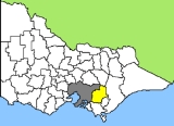
Baw Baw Shire
Encyclopedia
Melbourne
Melbourne is the capital and most populous city in the state of Victoria, and the second most populous city in Australia. The Melbourne City Centre is the hub of the greater metropolitan area and the Census statistical division—of which "Melbourne" is the common name. As of June 2009, the greater...
in the West Gippsland
Gippsland
Gippsland is a large rural region in Victoria, Australia. It begins immediately east of the suburbs of Melbourne and stretches to the New South Wales border, lying between the Great Dividing Range to the north and Bass Strait to the south...
region. It has an area of 4,031 square kilometres, and in 2006 had a population of 37,179.
Baw Baw was formed in 1994 from the amalgamation of the former Buln Buln
Shire of Buln Buln
The Shire of Buln Buln was a Local Government Area located about east-southeast of Melbourne, the state capital of Victoria, Australia. The shire covered an area of , and existed from 1878 until 1994.-History:...
and Narracan
Shire of Narracan
The Shire of Narracan was a Local Government Area located about east-southeast of Melbourne, the state capital of Victoria, Australia. The shire covered an area of , and existed from 1878 until 1994.-History:...
shires, the Rural City of Warragul
Rural City of Warragul
The Rural City of Warragul was a Local Government Area located about east-southeast of Melbourne, the state capital of Victoria, Australia. The shire covered an area of , and existed from 1881 until 1994.-History:...
(previously the Shire of Warragul), and some parts of the Shire of Upper Yarra
Shire of Upper Yarra
The Shire of Upper Yarra was a Local Government Area centred on the upper reaches of the Yarra Valley about east of Melbourne, the state capital of Victoria, Australia, and extending eastwards into Victoria's interior. The shire covered an area of , and existed from 1888 until 1994.-History:Upper...
. It was named for Mount Baw Baw
Mount Baw Baw
Mount Baw Baw is a mountain in Victoria, Australia. Mount Baw Baw Alpine Resort is an Unincorporated area of Victoria surrounded by the Shire of Baw Baw.-Location:...
in the shire's northeast, its highest peak and the site of a small ski resort.
The more densely populated southern half of the Shire consists of low rolling hills given over primarily to dairy farming and other agriculture. The northern half lies in the Great Dividing Range
Great Dividing Range
The Great Dividing Range, or the Eastern Highlands, is Australia's most substantial mountain range and the third longest in the world. The range stretches more than 3,500 km from Dauan Island off the northeastern tip of Queensland, running the entire length of the eastern coastline through...
and its foothills, where forestry remains an important industry. Tourism is also important in the region, aided by its proximity to and easy access from Melbourne. The shire is noted for its rural scenery and natural beauty, as well as gourmet foods and wines. The historic gold-mining town of Walhalla
Walhalla, Victoria
Walhalla is a small town in Victoria, Australia, founded as a gold-mining community in early 1863 and at its peak home to around 2,500 residents. Today, the town has a population of fewer than 20 permanent residents, though it has a large proportion of houses owned as holiday properties. It...
is located in the northeast of the shire. The major electricity-producing region of the Latrobe Valley
Latrobe Valley
The Latrobe Valley is an inland geographical region and urban area of Gippsland in the state of Victoria, Australia. It is east of the City Of Melbourne and nestled between the Strzelecki Ranges to the south and the Great Dividing Range to the north – with the highest peak to the north of the...
lies immediately to the shire's east.
Many of the Shire's larger towns are located along the Princes Highway
Princes Highway
The Princes Highway extends from Sydney to Port Augusta via the coast through the states of New South Wales, Victoria and South Australia, a distance of 1941 km or 1898 km via the former alignments of the highway ....
and main Gippsland Railway line, which cross the southern part of the shire. From west to east these include: Longwarry
Longwarry, Victoria
Longwarry is a town in Victoria, Australia, situated south-east of Melbourne. It is bypassed by the Princes Freeway. Its Local Government Area is the Shire of Baw Baw.-History:The Post Office opened on 20 June 1881 some time after the railway arrived in 1879...
, Drouin
Drouin, Victoria
Drouin is a major service town, located in West Gippsland, east of Melbourne. Its local government area is the Shire of Baw Baw. The town is supposedly named after a Frenchman who invented a chlorination process for the extraction of ore or an Aboriginal word meaning "north wind". New estate...
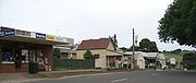
, Warragul
Warragul, Victoria
Warragul is a rural centre with a population of 12,943 people east-southeast of Melbourne in Victoria. Warragul lies between the Strzelecki Ranges to the south and the Mount Baw Baw Plateau of the Great Dividing Range to the north...
(the largest town and administrative centre), Darnum
Darnum, Victoria
Darnum is a small town in West Gippsland, Victoria, Australia, located 110 km east of Melbourne, in the Shire of Baw Baw. At the 2006 census the town and surrounding area had a population of 598....
, Yarragon
Yarragon, Victoria
Yarragon is a small town in the West Gippsland region of Victoria, Australia. The town lies on the Princes Highway and the main Gippsland Railway line approximately halfway between the major towns of Warragul and Moe...
, and Trafalgar
Trafalgar, Victoria
Trafalgar is a town in the West Gippsland region of Victoria, Australia. The town lies on the Princes Highway and main Gippsland railway line about west of Moe. The town backs onto the foothills of the Strzelecki Ranges to the south...
. North of Warragul are Fumina South
Fumina South, Victoria
Fumina South is a town in Victoria, Australia. Located on Willowgrove Road, in the Shire of Baw Baw, it is an isolated pocket near the foothills of Mount Baw Baw...
, Neerim South
Neerim South, Victoria
Neerim South is a town in West Gippsland, Victoria, Australia, located in the Shire of Baw Baw, east of Melbourne and north of Warragul. At the 2006 census, Neerim South and the surrounding area had a population of 1,602....
and Noojee
Noojee, Victoria
Noojee is a town in the Gippsland region of Victoria, Australia, located north of Warragul and east of Melbourne, in the Baw Baw local government area. At the 2006 census, Noojee and the surrounding area had a population of 261....
(from which runs the main road to Mount Baw Baw), while south of Trafalgar in the Strzelecki Ranges
Strzelecki Ranges
Strzelecki Ranges, also known as Strzelecki Hills is a low mountain range in the Gippsland region of south-eastern Australia between the Latrobe Valley to the north and Bass Strait to the south...
lies the town of Thorpdale
Thorpdale, Victoria
Thorpdale is a small country town in the Gippsland area of eastern Victoria, Australia, less than 20 km south of Trafalgar. Famous for its potatoes, it is located amongst the rich farmland of the Latrobe Valley. Thorpdale spuds are eaten around the country and also exported overseas. The name...
. The towns of Rawson
Rawson, Victoria
Rawson is a town in Victoria, Australia, located on Tyers - Thomson Valley Road, in the Shire of Baw Baw. The town was established for workers involved in the construction of the Thomson Dam, which was completed in 1983, Rawson Post Office opening on 17 April 1979....
, Erica
Erica, Victoria
Erica is a town in Victoria, Australia, located on Rawson Road, in the Shire of Baw Baw.The area was generally known as Upper Moondarra in the early 1900s, the township of Erica beginning to grow after construction of the railway line from Moe to Walhalla, which passed through the area...
and Parkers Corner
Parkers Corner, Victoria
Parkers Corner is a town in Victoria, Australia, located at the junction of Rawson Road and Tyers - Thomson Valley Road, in the Shire of Baw Baw. With only 12 residents, it is the second-smallest town in Victoria....
are located near Walhalla amongst the foothills of Mount Baw Baw. The continuing inclusion of these small centres in Baw Baw Shire is locally contentious due to the isolation from the administrative capital of Warragul. Being geographically and socially connected to the major Latrobe Valley towns of Moe, Morwell and Traralgon, there are strong local feelings that their needs would be better met by a minor boundary adjustment that would place the northern towns into the City of Latrobe.
Wards
- Drouin (Two councillors)
- Mount Worth (Two councillors)
- North (Two councillors)
- Warragul (Three councillors)