
Battle of 73 Easting
Overview
Tank
A tank is a tracked, armoured fighting vehicle designed for front-line combat which combines operational mobility, tactical offensive, and defensive capabilities...
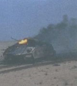
battle fought on 26 February 1991, during the Gulf War
Gulf War
The Persian Gulf War , commonly referred to as simply the Gulf War, was a war waged by a U.N.-authorized coalition force from 34 nations led by the United States, against Iraq in response to Iraq's invasion and annexation of Kuwait.The war is also known under other names, such as the First Gulf...
, between American
United States Army
The United States Army is the main branch of the United States Armed Forces responsible for land-based military operations. It is the largest and oldest established branch of the U.S. military, and is one of seven U.S. uniformed services...
-British
British Army
The British Army is the land warfare branch of Her Majesty's Armed Forces in the United Kingdom. It came into being with the unification of the Kingdom of England and Scotland into the Kingdom of Great Britain in 1707. The new British Army incorporated Regiments that had already existed in England...
armored forces and those of the Iraq
Iraq
Iraq ; officially the Republic of Iraq is a country in Western Asia spanning most of the northwestern end of the Zagros mountain range, the eastern part of the Syrian Desert and the northern part of the Arabian Desert....
i Republican Guard. The battle took place several hours after the Battle of Al Busayyah
Battle of Al Busayyah
The Battle of Al Busayyah was a tank battle fought just before sunrise on February 26, 1991, during the Gulf War, between armored forces of the United States Army and those of the Iraqi Army.-Description:...
. It was named for a UTM
Universal Transverse Mercator coordinate system
The Universal Transverse Mercator geographic coordinate system uses a 2-dimensional Cartesian coordinate system to give locations on the surface of the Earth. It is a horizontal position representation, i.e...
north-south coordinate line (an "Easting", measured in kilometers and readable on GPS receivers) in the featureless desert that was used as a phase line
Phase line (cartography)
In cartography, a phase line is a line to show some positional dependency or relation to the passage of time, most often changing phases of a military operation, or changing borders in histogeographic maps.-Military usage:...
to measure progress of the offensive.