
.gif)
Battle River (Canada)
Encyclopedia
Battle River is a river in central Alberta
and western Saskatchewan
. It is a major tributary of the North Saskatchewan River
.
The Battle River flows for 570 kilometres (354.2 mi) and has a total drainage area of 30300 square kilometres (11,698.9 sq mi). The mean discharge is 10 m³/s at its mouth.
in central Alberta, east of Winfield
and meander
s east into Saskatchewan, where it discharges in the North Saskatchewan River at Battleford.
Big Knife Provincial Park
is established along the river, between Donalda and Forestburg
. Other communities located on the river include Ponoka
, Wetaskiwin
, Camrose
, New Norway
, Edberg
, Rosalind
, Duhamel
, Forestburg
, Galahad, Alliance
, Hardisty
, Wainwright
, Marsden
, Lashburn
, Waseca
, Maidstone
and Paynton
.
Battle Lake, Samson Lake, Driedmeat Lake and Big Knife Lake are formed along the river, and numerous other lakes (such as Pigeon Lake
, Coal Lake, Bittern Lake, Vernon Lake, Ernest Lake, Soda Lake) are developed in the Battle River hydrographic basin.
Alberta
Alberta is a province of Canada. It had an estimated population of 3.7 million in 2010 making it the most populous of Canada's three prairie provinces...
and western Saskatchewan
Saskatchewan
Saskatchewan is a prairie province in Canada, which has an area of . Saskatchewan is bordered on the west by Alberta, on the north by the Northwest Territories, on the east by Manitoba, and on the south by the U.S. states of Montana and North Dakota....
. It is a major tributary of the North Saskatchewan River
North Saskatchewan River
The North Saskatchewan River is a glacier-fed river that flows east from the Canadian Rockies to central Saskatchewan. It is one of two major rivers that join to make up the Saskatchewan River....
.
The Battle River flows for 570 kilometres (354.2 mi) and has a total drainage area of 30300 square kilometres (11,698.9 sq mi). The mean discharge is 10 m³/s at its mouth.
Course
The Battle River originates south from Battle LakeBattle Lake (Alberta)
Battle Lake is a lake in Alberta, Canada. It is located in the county of Wetaskiwin approximately southwest of Edmonton. A hamlet by the same name is located just east of the lake. Battle River originates in the lake....
in central Alberta, east of Winfield
Winfield, Alberta
Winfield is a hamlet in Alberta, Canada within the County of Wetaskiwin No. 10. It is located at the intersection of Highway 13 and Highway 20, approximately west of Wetaskiwin.- Climate :- External links :* - from Alberta Municipal Affairs and Housing...
and meander
Meander
A meander in general is a bend in a sinuous watercourse. A meander is formed when the moving water in a stream erodes the outer banks and widens its valley. A stream of any volume may assume a meandering course, alternately eroding sediments from the outside of a bend and depositing them on the...
s east into Saskatchewan, where it discharges in the North Saskatchewan River at Battleford.
Big Knife Provincial Park
Big Knife Provincial Park
Big Knife Provincial Park is a small provincial park in central Alberta, Canada.It was established in 1962 on the Battle River, at the confluence with the Big Knife Creek and is located between the villages of Donalda and Forestburg, 10 km south of highway 53, 88 km from the city of...
is established along the river, between Donalda and Forestburg
Forestburg, Alberta
- External links :*...
. Other communities located on the river include Ponoka
Ponoka, Alberta
Ponoka is a town in the province of Alberta, Canada. It is situated in the south/central parkland region of rolling hills. Industries are agriculture , and oil and gas production...
, Wetaskiwin
Wetaskiwin, Alberta
Wetaskiwin is a small city in the province of Alberta, Canada. The city is located south of the provincial capital of Edmonton. The city name comes from the Cree word wītaskīwin-ispatinaw , meaning "the hills where peace was made"....
, Camrose
Camrose, Alberta
Camrose is a city in central Alberta, Canada, amid some of the richest farmland in the prairies. It is a relatively small city which originally grew up along a railroad and now grows along Highway 13. Camrose is a scenic community with many parks, leading to its moniker "The Rose City"...
, New Norway
New Norway, Alberta
New Norway is a small rural village located in the central prairies of Alberta, Canada. Named in 1895 and properly established in 1909, it is located on Hwy 21, approximately 100 kilometres SSE of Edmonton and 22 kilometres SW of Camrose, the closest major trading center.With a population of over...
, Edberg
Edberg, Alberta
Edberg is a village in central Alberta approximately south of Camrose.- Demographics :In 2006, Edberg had a population of 155 living in 63 dwellings, a 3.3% increase from 2001. The village has a land area of and a population density of ....
, Rosalind
Rosalind, Alberta
Rosalind is a village located in the prairies of central Alberta, Canada. It is located on Highway 854, approximately southeast of Edmonton and southeast of Camrose, the closest major trading centre....
, Duhamel
Duhamel, Alberta
Duhamel is a hamlet in the central Alberta, Canada within Camrose County. It is located on Highway 21, approximately southeast of Edmonton and southwest of Camrose, Duhamel's closest major trading centre.- Early history :...
, Forestburg
Forestburg, Alberta
- External links :*...
, Galahad, Alliance
Alliance, Alberta
Alliance is a village in central Alberta, Canada. Established as a station on a Canadian National line in 1916, Alliance became a village in 1918. It is located on Highway 602, approximately east of Red Deer...
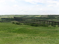
, Hardisty
Hardisty, Alberta
Hardisty, Alberta is a town in Flagstaff County in Alberta, Canada. It is located in east-central Alberta, from the Saskatchewan border, near the crossroads of Highway 13 and Highway 881, in the Battle River Valley.- History :...
, Wainwright
Wainwright, Alberta
Wainwright is a town on the prairies of east-central Alberta, Canada.It is located on the north side of the Canadian National Railway, with CFB Wainwright located on the southwest side. The town lies south of Vermilion, in the Battle River valley, along Highway 41, called the Buffalo Trail....
, Marsden
Marsden, Saskatchewan
-Arts and culture:Marsden is also the host of the annual Quad War, a Society for Creative Anachronism event. It is a Renaissance/Middle Ages full costume festival and war. It attracts approximately 500 people, mostly society members from Alberta and Saskatchewan. It is usually held in the first...
, Lashburn
Lashburn, Saskatchewan
-Demographics:-External links:...
, Waseca
Waseca, Saskatchewan
-Area statistics:*Lat 53°6′ N*Long 109°28′ W*Dominion Land Survey 32-47-24-W3*Time zone Mountain Standard Time , Mountain Daylight-Saving Time -Climate:-Location: -See also:...
, Maidstone
Maidstone, Saskatchewan
-Transportation:The community is served by Maidstone Aerodrome which is located northwest.-External links:...
and Paynton
Paynton, Saskatchewan
- See also :* List of communities in Saskatchewan* Villages of Saskatchewan-External links:*******-Footnotes:...
.
Tributaries
- Sunny Creek
- Wolf Creek
- Pigeon Lake Creek
- Stoney Creek
- Pipestone CreekPipestone CreekPipestone Creek is a waterway that runs through central Alberta, Canada. For example, over of Pipestone Creek parkland is situated in Millet, Alberta, with a combination of meadows and urban forest.It originates east of Pigeon Lake and flows east...
- Driedmeat Creek
- Meeting Creek
- Paintearth Creek
- Castor Creek
- Iron Creek
- Ribstone Creek
Battle Lake, Samson Lake, Driedmeat Lake and Big Knife Lake are formed along the river, and numerous other lakes (such as Pigeon Lake
Pigeon Lake (Alberta)
Pigeon Lake is a large lake in central Alberta, Canada. It is a popular recreation lake, with some shores having sandy beaches and others having steeper banks that are less suitable to "beach activities". Pigeon Lake is located close to large communities such as Edmonton, Leduc and Wetaskiwin...
, Coal Lake, Bittern Lake, Vernon Lake, Ernest Lake, Soda Lake) are developed in the Battle River hydrographic basin.
See also
- List of rivers of Alberta
- List of rivers of Saskatchewan
- Battle River No. 438, SaskatchewanBattle River No. 438, SaskatchewanBattle River No. 438 is a rural municipality in the Canadian province of Saskatchewan.-Statistics:According to the Canada 2006 Census:*Population: 1,053*Dwellings: 427*Area : 1,061.40*Density : 1.0-Communities:...
, rural municipality