

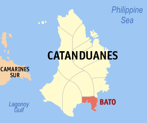
Bato, Catanduanes
Encyclopedia
Philippines
The Philippines , officially known as the Republic of the Philippines , is a country in Southeast Asia in the western Pacific Ocean. To its north across the Luzon Strait lies Taiwan. West across the South China Sea sits Vietnam...
. According to the 2007 census, it has a population of 18,738 people in 3,497 households.
Geography
Bato is located at the southeastern portion of Catanduanes and is bounded on the north by the municipality of San Miguel; on the east by the greatest body of water, the Pacific Ocean; on the south by Cabugao Bay and on the West of Virac, the capital town of Catanduanes which is just 8 kilometers from Bato.Meridional coordinates of the municipality's location are: 124deg15'16" to 124deg21'7" longitude and 13deg32'50" to 13deg38'47" latitude.
Barangays
Bato is politically subdivided into 27 BarangayBarangay
A barangay is the smallest administrative division in the Philippines and is the native Filipino term for a village, district or ward...
s.
| Barangay | Pop. (2007) |
|---|---|
| Aroyao Pequeño | |
| Bagumbayan | |
| Banawang | |
| Batalay | |
| Binanwahan | |
| Bote | |
| Buenavista | |
| Cabugao | |
| Cagraray | |
| Barangay | Pop. (2007) |
|---|---|
| Carorian | |
| Guinobatan | |
| Libjo | |
| Marinawa | |
| Mintay | |
| Oguis | |
| Pananaogan | |
| Libod Poblacion | |
| San Andres | |
| Barangay | Pop. (2007) |
|---|---|
| San Pedro | |
| San Roque | |
| Santa Isabel | |
| Sibacungan | |
| Sipi | |
| Talisay | |
| Tamburan | |
| Tilis | |
| Ilawod (Pob.) | |
Topography
The elevation varies from sea level to about 700 meters above sea level, The areas of flat lands along the coasts of Cabugao Bay and the Pacific Ocean and those along the banks of Bato River provide agricultural and recreational uses.Geological Feature
Stability and permeability of basic rock formation could be seen in the geologic map the existemce of fault line along barangays Oguis, Sipi, Binanuahan, Cabugao and San Andres. These areas are considered critical especially in terms of development as urban expansion. Like other municipalities in the province of Catanduanes, Bato has many mineral deposits like gold, manganese, coal and copper.Soil Classification
The municipality of Bato is composed of fivev v(5) kinds of soils namely: hydrosol, mountain soil, alimodian clay loam, louisianna clay, and San Miguel silt loam.Slope
The flat lands are mostly found along the coast of Cabugao Bay along the banks of the Bato River. These flat lands with a sloe of 0-3% occupies an average area of 25-30% of the entire hectarage of Bato. The Poblacion which is located along the eastern side of the Bato River is among the barangays having this slope, characterized to be level to nearly level land. However, due to its location, the Poblacion together with the adjoining barangays frequently suffer floods. The eastern portion of Bato which faces the Pacific Ocean has a slope ranging between 3-30% slope. These areas shield the lowlands of the municipality from the incoming winds of the Pacific. These areas are mostly planted to orchard, hard wood trees and abaca.River
At the heart of Bato lies a river stretching as far as Viga to the Cabugao Bay. Once, it was abundant in marine life but due to erosion and consistent flooding, the riverbed has been dumped with soil and this caused the river to get shallow and dry up. In the southern part of the Bato River is a delta, locally known as the Napo. Here farmers grow their agriculture such as peanuts, sweet potatoes, corn, beans, coconuts and palms. It is also the site for settling carabaos.The River divides Bato into the east and west district. The Bato bridge, the longest in the Bicol region, spans the river from Baranggay Tilis to Baranggay Sipi. The old bridge is located in Baranggay Balongbong, and it was destroyed during the flooding of the supertyphoon Rosing(1994).
Pre- Spanish Era Early Settlers
It has been known that the early Muslim settlers came from Borneo and Malaysia during the 13th Century before the Spanish colonization. Many of these Muslim settlers are traders and carried their true names like "Bato" who started their settlements in the area and later spread to the other regions of Visayas, Mindanao, and Luzon. Many Bato's ascendants and descendant's names originated from these three Bato's places in the Philippines.Post Spanish Era Name Registration
During the Spanish colonization of the Philippines around the 17th Century the King of Spain declared an order to have all the Filipinos registered by changing their names to Spanish names for the purpose of easy name identification, taxation, and control of all the settlements. These were the starts of why the majority of the Filipinos about 90% of them have the Hispanic names, such as; Caballero, Lopez, Perez, Mendez, Hernandez, etc, with similarities to other Countries conquered by Spain like Mexico, and others.The majority of the original Muslim settlers did not change their names to Spanish names as a sign of their rebellion to the Spaniard colonization, like Datu Lapu Lapu, and other Muslim natives. During this time period of Spanish colonization many other Filipinos non-Muslim settlers in other areas of the Philippines, also did not converted their names to Spanish names, they kept their original names, such as; Paglinawan, Bayani, Tawid, Tubig, Saya, Ilog, and anything else not related to foreign Spanish names.
The Beginning of the Town's name Bato
The Spaniard Colonization, who surveys the early settlers of the area, recorded the name "Bato" and later became the Town's name up to the present time. There are so many unlikely version of where and why the town was name "Bato", like it came from the name of the "water Wells", or it came from the name of the "Rock" which mean "Bato". The above version of the story "says that the Spaniard asked the woman settlers, of what is the name of the settlement? the woman replied "Bato". Whether the woman understands the question or not, her "Bato" answers are correct, she may be just mentioning her name "Bato" or the name of the settlement itself, as evidenced by their early occupations of the area. See many Filipinos descendant with Bato's last name.Housing
With the present population of 19,269, Bato has 3,712 households, thereby placing the average family size at 5 members. It has a total of 3,667 occupied dwelling units. Of this dwelling units, 1,908 or 52.03% used concrete/brick/stone as their outer walls followed by bamboo/sawali/cogon and nipa which composes 29.42%. Asbestos/glass is the least used which accounts for only 7 houses or 0.19%.Dwelling units have also been classified into single houses, duplex, multi-unit residential, institutional, living quarters and others. Thus of the total number of households, 99% or 3,644 occupies single house while the rest of 1% are either duplex or multi unit residential.
Health
The municipality of Bato avails of the services of two (2) major health facilities. These include one (1) hospital and one (1) rural health unit, which is located in Barangay Tamburan and Poblacion respectively. There used to be eight (8) barangay health stations located in barangays Batalay, Bote, San Roque Bagumbayan, Buenavista, Binanuahan, Sibacingan, and Caagraray.The Bato Maternity and Children's Hospital which is under the administration of the Provincial Government of Catanduanes is catering the needs of the three (3) municipalities, namely: Bato, Baras, and San Miguel. It has a capacity of 50 beds whose services include consultations, admissions and minor surgeries. On the other hand, the Rural Health unit, which is under the administration of the Municipal Government of Bato, serves the needs of the 27 barangays of the municipality. Its services are medical/surgical services, laboratory services, family planning and women's health services, oral rehydration therapy
Oral rehydration therapy
Oral rehydration therapy is a simple treatment for dehydration associated with diarrhoea, particularly gastroenteritis or gastroenteropathy, such as that caused by cholera or rotavirus. ORT consists of a solution of salts and sugars which is taken by mouth...
, TB Control, immunization, medico legal and social services, environmental health services, pre-marriage counseling, delivery calls and nutrition services.
Speaking of the health status of the municipality, for CY 1999, the Office of the Municipal Civil Registrar posted a live birth of 307, 159 of which are males and 148 are females. Likewise it recorded 89 deaths in age group 50 years and over. The Municipal Health Office for the same year recorded a crude birth rate of 27.47% and an infant mortality rate of 0.83%.
Education
Almost 35.05% of the total population of the municipality or 7,415 comprises the school-going age population. The primary school-going population aged 6–10 years old are 2,570; the intermediate school-going population aged 11–12 years old are 993; the secondary school-going population aged 13–16 are 1,858 and the tertiary school-going population aged 17–21 are 1,994.A survey of the actual enrollment revealed that there is an enrollment participation rate of 90.43%. This could be interpreted that for every 100 children aged 6–14 only 90 are enrolled. For secondary education out of 1,858 only 1,359 are enrolled.
A tertiary school is not present in the municipality, however post-secondary vocational courses are being offered by the school founded by the late mayor, Hon. Andres T.Torres, the Cabugao School of Handicraft and Cottage Industries (CSHCI) which is now under the administration and management of the TESDA. Originally, CSHCI was established to cater free secondary education to the people of Cabugao and other neighboring barangays and municipalities.
Protective
Protective services are being served by the police force, the firemen and the barangay brigades. All in all these force totals 164, broken down as follows: 17 policemen, 4 firemen, and 143 members of the barangay brigades.Due to the absence of a PNP Building, the police station is presently located at the Municipal Hall with a floor area of 70.00 square meters. On the other hand, the fire station is occupying a total area of 60 square meters. The Barangay Brigades of Bato with a total force of 143 could be found all throughout the different barangays.
Social Welfare
The municipality of Bato avails of the social welfare services of the government agency popularly known as the Department of Social Welfare and Development. This agency has two devolved personnel for Bato. Its services are extended to all the urban and rural barangays of the municipality and include among other: family life education and counseling, day care services, peer group service, supplemental feeding, relief rehabilitation and referral for medical care.The organizations present in this municipalities are: Senior Citizens Organization, Women's Organization and Parents Committee. Barangay Aroyao Pequeno has the greatest number of these organizations while the rest have the same number and type of these organizations.