
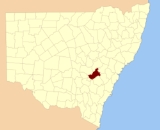
Bathurst County, New South Wales
Encyclopedia
Bathurst County was one of the original Nineteen Counties
in New South Wales
and is now one of the 141 Cadastral divisions of New South Wales
. It includes the area to the south west of Bathurst
to Cowra and Orange
. The Lachlan River
is the boundary to the south-west, the Belubula River
forms part of the northern boundary, with the Fish River
on the northeastern boundary. Blayney
is located roughly in the middle.
Bathurst County was named in honour of Henry Bathurst
, 3rd Earl between (1762–1834).. The Electoral district of Bathurst (County)
was the first state electoral district for the area, between 1856 and 1859.
 In 1852 it had an area of 1196400 acres (4,841.7 km²) and population of 6,405. At this time it was described as having some of the best wool
in the colony, with excellent farming land.
Nineteen Counties
The Nineteen Counties were the limits of location in the colony of New South Wales defined by the Governor of New South Wales Sir Ralph Darling in 1826 in accordance with a government order from Lord Bathurst, the secretary of State. Counties had been used since the first year of settlement, with...
in New South Wales
New South Wales
New South Wales is a state of :Australia, located in the east of the country. It is bordered by Queensland, Victoria and South Australia to the north, south and west respectively. To the east, the state is bordered by the Tasman Sea, which forms part of the Pacific Ocean. New South Wales...
and is now one of the 141 Cadastral divisions of New South Wales
Cadastral divisions of New South Wales
Lands administrative divisions of New South Wales refers to the 141 counties within the Australian state of New South Wales, which are further subdivided into 7,459 parishes. There are also three Land Divisions, around 100 Land Districts, and several other types of districts as well as land boards...
. It includes the area to the south west of Bathurst
Bathurst, New South Wales
-CBD and suburbs:Bathurst's CBD is located on William, George, Howick, Russell, and Durham Streets. The CBD is approximately 25 hectares and surrounds two city blocks. Within this block layout is banking, government services, shopping centres, retail shops, a park* and monuments...
to Cowra and Orange
Orange, New South Wales
Orange is a city in the Central West region of New South Wales, Australia. It is west of the state capital, Sydney, at an altitude of . Orange has an estimated population of 39,329 and the city is a major provincial centre....
. The Lachlan River
Lachlan River
- Course :The river rises in the central highland of New South Wales, part of the Great Dividing Range, 13 km east of Gunning. Its major headwaters, the Carcoar River, the Belubula River and the Abercrombie River converge near the town of Cowra. Minor tributaries include the Morongla Creek...
is the boundary to the south-west, the Belubula River
Belubula River
The Belubula River is a river of the state of New South Wales in Australia. It flows from Vittoria State Forest South of Vittoria to its confluence with the Lachlan River, East of Gooloogong....
forms part of the northern boundary, with the Fish River
Fish River (New South Wales)
- Rivers :There are two rivers in New South Wales called the Fish River.The Fish River rises on the plateau south east of Oberon, New South Wales, and flows generally to the north-west, becoming the main headwater of the Macquarie River just east of Bathurst, New South Wales. There is a reservoir...
on the northeastern boundary. Blayney
Blayney, New South Wales
Blayney is a farming town and administrative centre with a population of 2,745 in 2006, in the Central West region of New South Wales, Australia...
is located roughly in the middle.
Bathurst County was named in honour of Henry Bathurst
Henry Bathurst, 3rd Earl Bathurst
Henry Bathurst, 3rd Earl Bathurst KG PC was a British politician.-Background and education:Lord Bathurst was the elder son of Henry Bathurst, 2nd Earl Bathurst, by his wife Tryphena, daughter of Thomas Scawen...
, 3rd Earl between (1762–1834).. The Electoral district of Bathurst (County)
Electoral district of Bathurst (County)
Bathurst was an electoral district of the Legislative Assembly in the Australian state of New South Wales, named after Bathurst County and including the rural part of the county. Bathurst town was included in Western Boroughs, until Bathurst was created in 1859...
was the first state electoral district for the area, between 1856 and 1859.
Wool
Wool is the textile fiber obtained from sheep and certain other animals, including cashmere from goats, mohair from goats, qiviut from muskoxen, vicuña, alpaca, camel from animals in the camel family, and angora from rabbits....
in the colony, with excellent farming land.
Parishes within this county
A full list of parishes found within this county; their current LGA and mapping coordinates to the approximate centre of each location is as follows:| Parish | LGA | Coordinates |
|---|---|---|
| Aberfoil | Cabonne Shire | 33°06′54"S 149°19′04"E |
| Anson | Cabonne Shire | 33°19′54"S 149°13′04"E |
| Apsley | Bathurst Regional Council Bathurst Regional Council Bathurst Regional Council administers the Bathurst Region Local Government Area in New South Wales, Australia. It is approximately 200 km west of Sydney and has a population of 37,001 . It is on the Great Western Highway, Mid-Western Highway, Mitchell Highway and the Main Western railway... |
33°30′54"S 149°34′04"E |
| Arkell | Bathurst Regional Council Bathurst Regional Council Bathurst Regional Council administers the Bathurst Region Local Government Area in New South Wales, Australia. It is approximately 200 km west of Sydney and has a population of 37,001 . It is on the Great Western Highway, Mid-Western Highway, Mitchell Highway and the Main Western railway... |
33°38′54"S 149°35′04"E |
| Bangaroo | Cowra Shire | 33°36′54"S 148°33′04"E |
| Bathurst Bathurst, New South Wales -CBD and suburbs:Bathurst's CBD is located on William, George, Howick, Russell, and Durham Streets. The CBD is approximately 25 hectares and surrounds two city blocks. Within this block layout is banking, government services, shopping centres, retail shops, a park* and monuments... |
Bathurst Regional Council Bathurst Regional Council Bathurst Regional Council administers the Bathurst Region Local Government Area in New South Wales, Australia. It is approximately 200 km west of Sydney and has a population of 37,001 . It is on the Great Western Highway, Mid-Western Highway, Mitchell Highway and the Main Western railway... |
33°25′54"S 149°34′04"E |
| Beaufort | Blayney Shire | 33°31′54"S 149°06′04"E |
| Belubula | Blayney Shire | 33°34′54"S 149°03′04"E |
| Beneree | Cabonne Shire | 33°25′54"S 149°05′04"E |
| Billimari Billimari, New South Wales Billimari is a small village, approximately 25 kilometres out of Cowra, New South Wales in the Cowra Shire. From the last census, it has a population of 80.Category:Towns in the Central West, New South Wales... |
Cowra Shire | 33°39′54"S 148°38′04"E |
| Blake | Blayney Shire | 33°31′54"S 148°59′04"E |
| Bracebridge | Cowra Shire | 33°48′54"S 148°58′04"E |
| Bringellet | Oberon Shire | 33°39′54"S 149°30′04"E |
| Byng | Cabonne Shire | 33°20′54"S 149°18′04"E |
| Cadogan | Bathurst Regional Council Bathurst Regional Council Bathurst Regional Council administers the Bathurst Region Local Government Area in New South Wales, Australia. It is approximately 200 km west of Sydney and has a population of 37,001 . It is on the Great Western Highway, Mid-Western Highway, Mitchell Highway and the Main Western railway... |
33°21′54"S 149°22′04"E |
| Calvert | Blayney Shire | 33°30′54"S 149°06′04"E |
| Canowindra Canowindra, New South Wales Canowindra is an historic township located near Cowra in the central west of New South Wales, Australia in Cabonne Shire. Canowindra is on the Belubula River. The curving main street, Gaskill Street, is partly an urban conservation area. At the 2006 census, Canowindra had a population of 1,499... |
Cowra Shire | 33°36′54"S 148°40′04"E |
| Carlton Carlton, New South Wales Carlton is a suburb in southern Sydney, in the state of New South Wales, Australia. Carlton is located 15 kilometres south of the Sydney central business district and is part of the St George area. Carlton lies across the boundary of two local government areas, the Municipality of Kogarah and the... |
Blayney Shire | 33°31′54"S 148°56′04"E |
| Chaucer | Cowra Shire | 33°35′54"S 148°47′04"E |
| Clarendon Clarendon, New South Wales Clarendon is a suburb of Sydney, in the state of New South Wales, Australia.Clarendon railway station is on the Richmond branch of the Western Line of the CityRail network.It is also home to Hawkesbury Racecourse and the Hawkesbury Show Ground.... |
Cabonne Shire | 33°27′54"S 148°58′04"E |
| Clinton | Cabonne Shire | 33°14′54"S 149°11′04"E |
| Cole | Bathurst Regional Council Bathurst Regional Council Bathurst Regional Council administers the Bathurst Region Local Government Area in New South Wales, Australia. It is approximately 200 km west of Sydney and has a population of 37,001 . It is on the Great Western Highway, Mid-Western Highway, Mitchell Highway and the Main Western railway... |
33°29′54"S 149°24′04"E |
| Coleridge | Bathurst Regional Council Bathurst Regional Council Bathurst Regional Council administers the Bathurst Region Local Government Area in New South Wales, Australia. It is approximately 200 km west of Sydney and has a population of 37,001 . It is on the Great Western Highway, Mid-Western Highway, Mitchell Highway and the Main Western railway... |
33°09′54"S 149°27′04"E |
| Colville | Cabonne Shire | 33°23′54"S 149°16′04"E |
| Coota | Cowra Shire | 33°49′54"S 148°46′04"E |
| Cowra Cowra, New South Wales Cowra is a town in the Central West region of New South Wales, Australia in the Cowra Shire. It is located on the Mid-Western Highway, 317 kilometres west of Sydney on the banks of the Lachlan River at an altitude of 310 metres above sea level. At the 2006 census Cowra had a population of 8,430... |
Cowra Shire | 33°46′54"S 148°44′04"E |
| Dunleary | Cowra Shire | 33°55′54"S 148°57′04"E |
| Egbert | Cowra Shire | 33°45′54"S 149°10′04"E |
| Errol | Blayney Shire | 33°33′54"S 149°11′04"E |
| Freemantle | Cabonne Shire | 33°14′54"S 149°20′04"E |
| Galbraith | Blayney Shire | 33°33′54"S 149°22′04"E |
| Glenlogan | Cowra Shire | 33°46′54"S 148°39′04"E |
| Graham | Blayney Shire | 33°27′54"S 149°12′04"E |
| Grantham | Bathurst Regional Council Bathurst Regional Council Bathurst Regional Council administers the Bathurst Region Local Government Area in New South Wales, Australia. It is approximately 200 km west of Sydney and has a population of 37,001 . It is on the Great Western Highway, Mid-Western Highway, Mitchell Highway and the Main Western railway... |
33°29′54"S 149°30′04"E |
| Hampton | Cowra Shire | 33°36′54"S 148°57′04"E |
| Huntley | Cabonne Shire | 33°22′54"S 149°07′04"E |
| Kenilworth | Cowra Shire | 33°45′54"S 148°50′04"E |
| Lennox | Cabonne Shire | 33°11′54"S 149°17′04"E |
| Lindsay | Blayney Shire | 33°30′54"S 149°13′04"E |
| Lowry | Bathurst Regional Council Bathurst Regional Council Bathurst Regional Council administers the Bathurst Region Local Government Area in New South Wales, Australia. It is approximately 200 km west of Sydney and has a population of 37,001 . It is on the Great Western Highway, Mid-Western Highway, Mitchell Highway and the Main Western railway... |
35°33′54"S 149°27′04"E |
| Lucan | Blayney Shire | 33°42′54"S 149°01′04"E |
| Lucan | Blayney Shire | 33°45′54"S 148°00′04"E |
| Lyndhurst Lyndhurst, New South Wales Lyndhurst is a small village in New South Wales, Australia in Blayney Shire. It is 4 kilometres west of Mandurama or about 269 km west of Sydney and 63 km south-west of Bathurst just off the Mid-Western Highway New South Wales. Once serving as the major centre for basic goods and needs... |
Blayney Shire | 33°37′54"S 149°01′04"E |
| Malmsbury | Bathurst Regional Council Bathurst Regional Council Bathurst Regional Council administers the Bathurst Region Local Government Area in New South Wales, Australia. It is approximately 200 km west of Sydney and has a population of 37,001 . It is on the Great Western Highway, Mid-Western Highway, Mitchell Highway and the Main Western railway... |
33°26′54"S 149°25′04"E |
| Malongulli | Cowra Shire | 33°35′54"S 148°53′04"E |
| Milburn | Cowra Shire | 33°53′54"S 148°49′04"E |
| Mount Pleasant Mount Pleasant, New South Wales Mount Pleasant is a suburb in the city of Wollongong, New South Wales, Australia. It is situated on the northern flank of Mount Keira extending across to the Illawarra escarpment. It is home to the Rhododendron Park, found on Parrish Avenue.-History:... |
Bathurst Regional Council Bathurst Regional Council Bathurst Regional Council administers the Bathurst Region Local Government Area in New South Wales, Australia. It is approximately 200 km west of Sydney and has a population of 37,001 . It is on the Great Western Highway, Mid-Western Highway, Mitchell Highway and the Main Western railway... |
33°25′54"S 149°31′04"E |
| Napier Napier, New South Wales Napier is a locality in the Riverina district of New South Wales, Australia. It was the site of a now-closed railway station between 1911 and 1967 on the Oaklands railway line. No trace of the station now remains.... |
Blayney Shire | 33°33′54"S 149°17′04"E |
| Neville Neville, New South Wales Neville is a small village in the south east of New South Wales, Australia, in Blayney Shire. It is 60km south of Bathurst or about 16 km south east of Mandurama. It is 940 metres above sea level and currently has a population of about 100.-History:... |
Blayney Shire | 33°40′54"S 149°14′04"E |
| Oakley | Bathurst Regional Council Bathurst Regional Council Bathurst Regional Council administers the Bathurst Region Local Government Area in New South Wales, Australia. It is approximately 200 km west of Sydney and has a population of 37,001 . It is on the Great Western Highway, Mid-Western Highway, Mitchell Highway and the Main Western railway... |
33°37′54"S 149°40′04"E |
| Orange Orange, New South Wales Orange is a city in the Central West region of New South Wales, Australia. It is west of the state capital, Sydney, at an altitude of . Orange has an estimated population of 39,329 and the city is a major provincial centre.... |
City of Orange City of Orange The City of Orange is a Local Government Area of New South Wales, Australia, including Orange and the surrounding areas. It is on the Mitchell Highway and the Main Western railway line.It includes the villages of Lucknow, Shadforth, Spring Hill and March.... |
33°18′42"S 149°07′07"E |
| Osborne Osborne, New South Wales Osborne is a village community in the central east part of the Riverina. It is situated by road, about 15 kilometres south from Lockhart and 19 kilometres west from Woodend.... |
Blayney Shire | 33°36′54"S 149°15′04"E |
| Ponsonby | Bathurst Regional Council Bathurst Regional Council Bathurst Regional Council administers the Bathurst Region Local Government Area in New South Wales, Australia. It is approximately 200 km west of Sydney and has a population of 37,001 . It is on the Great Western Highway, Mid-Western Highway, Mitchell Highway and the Main Western railway... |
33°36′54"S 149°33′04"E |
| Purfleet | Cowra Shire | 33°51′54"S 149°00′04"E |
| Roseberg | Cowra Shire | 33°50′54"S 149°05′04"E |
| Shadforth | Cabonne Shire | 33°23′54"S 149°12′04"E |
| Shaw | Blayney Shire | 33°37′54"S 149°10′04"E |
| Somers | Blayney Shire | 33°40′54"S 149°07′04"E |
| St David | Bathurst Regional Council Bathurst Regional Council Bathurst Regional Council administers the Bathurst Region Local Government Area in New South Wales, Australia. It is approximately 200 km west of Sydney and has a population of 37,001 . It is on the Great Western Highway, Mid-Western Highway, Mitchell Highway and the Main Western railway... |
33°11′54"S 149°24′04"E |
| Tenandra | Cowra Shire | 33°39′54"S 148°47′04"E |
| Three Brothers Three Brothers, New South Wales The Three Brothers are three mountains in the Camden Haven district on the Mid North Coast of New South Wales, Australia. They were named by Captain James Cook during his voyage along the east coast of Australia in May 1770.The mountains are named:... |
Blayney Shire | 33°38′54"S 149°21′04"E |
| Tintern | Cowra Shire | 33°49′54"S 148°53′04"E |
| Torrens | Blayney Shire | 33°28′54"S 149°19′04"E |
| Vittoria | Cabonne Shire | 33°24′54"S 149°22′04"E |
| Waldegrave | Cabonne Shire | 33°24′54"S 149°00′04"E |
| Walli | Cabonne Shire | 33°40′54"S 148°52′04"E |
| Waugoola | Cowra Shire | 33°46′54"S 148°56′04"E |
| Worcester | Cabonne Shire | 33°15′54"S 149°14′04"E |