

Baruta Municipality
Encyclopedia
Baruta Municipality belongs politically to the Greater Caracas
Municipality in Venezuela
. It is located geographically in the South-East section of the city. Its western limit is the Los Chaguaramos neighborhood (which belongs to the Libertador Municipality) and limits to the east with the Colinas de Los Ruices neighborhood, in the Sucre Municipality
. To the North, it borders with the Francisco Fajardo Highway
and to the Southeast with the El Hatillo Municipality and to the Southwest with the Hoyo de la Puerta neighborhood (Libertador Municipality).
Although some of the political functions overlap with the Greater Caracas
Municipality, Baruta has its own Mayor, Gerardo Blyde. The local government has its own police force, among other responsibilities. The City Hall is currently located in the Bello Monte district, but there are plans for it to be moved to the old Baruta town.
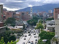
The main economic activity in Baruta is non-manufacturing business in the many office buildings within the Municipality. For example, the Procter & Gamble
Latin American Headquarters are located there. Commerce is also a great source of revenue for the Baruteños, as some of the most attractive night spots in the Greater Caracas are located in Las Mercedes district.
The Baruta Zip Code is 1080 and the Area Code is 212, the same as the Greater Caracas
area.
and his territory. on March 20, 1568, Diego de Losada
offers to Captain Alonso Andrea de Ledesma an important mission to located the land and possessions of the Baruta cacique, with the purpose of coverting the Indians to Catholicism, and teaching them to read and to write, as well as to train them in the exercise of the chieftainship. This offer was ratified by the City Hall of Caracas on February 20, 1582, considering this date the beginning of the process of foundation.
On August 19, 1620 Baruta town was founded with the name of "San Francisco de Paula", taking place therefore the first establishment of population of certain importance in the Southeastern part of Caracas
. The Governor of the Province st the teim and the Bishop, Francisco de Hoz y Berrío and Fray Gonzalo de Angulo, respectively, decreed to the consecration of the Church of Villa del Rosario de Baruta on July 14, 1655. The great land extensions of the zone were conformed by prosperous properties, whose yield was based on the production of coffee
, cane
and cacao, as well as alcoholic beverages, sugar
and papelón. La Guairita, Manzanares, La Trinidad and Las Mercedes were great farms, constituting themselves in the origins of the most important urbanizations of the Municipality at the present time. The construction of the road from Caracas to Baruta and the Hatillo took place between 1927 and 1929, giving the urbanizing process in Las Mercedes in the 1940s, and in the 1950s the Municipality begins to experience a great demographic expansion.
In 1961 the Prados del Este Highway was concluded and in 1965 the project of the Universidad Simón Bolívar
began in Sartenejas, in the 1960s the urbanizations El Cafetal, Santa Marta, Santa Sofía, San Luis, Santa Paula, Cerro Verde and Los Naranjos were constructed. Baruta was semi-independent until 1954, date in which passes its administration to the Council of Petare, forming part of the extinct Sucre District of the Miranda state
, jointly with Petare, Chacao and El Hatillo. Due to the height and vertiginous growth that the Municipality has confronted, the Legislative Assembly of the Miranda state
declared Baruta like independent Municipality on September 22, 1987. In this sense, their characteristics of socioeconomic and geographic development allowed the creation of the El Hatillo Municipality on January 1992. On April 1992 the parish
of Las Minas de Baruta was created.
 The Baruta Municipality comprises the territory of the Miranda state
, jointly with other 20 Municipalities. As well, it forms part of the metropolitan area of Caracas
next to the Chacao Municipality
, Libertador, Sucre and the El Hatillo municipality
. It has a favorable geographic location, acting like integrating element of the Southeastern of Caracas with the rest of the municipalities of the metropolitan area of Caracas. It limits by the North with the municipalities Libertador, Chacao and Sucre, by the East with the municipalities: Sucre, El Hatillo and Paz Castillo by the South with the municipalities Cristóbal Rojas and Guaicaipuro and by the West with the municipality Los Salias and the Libertador Municipality
of the Capital District.
It has a surface of 9,392, 65 km², representing approximately 14% of the metropolitan area of Caracas. It is important to indicate that of the total area of the municipality, 43% comprise of the Protective Zone of Caracas, which is under the Regime of Special Administration. It is located between the coordinates (UTM - Canoe): (729,900 me - 745,037 me; 1.144.245 mN - 1.160.854 mN)
Parishes
 The constitution of Venezuela
specifies that municipal governments be divided into executive
and legislative branches. The executive government of the municipality is governed by the mayor, while the legislative government is managed by the Municipal council. On March 8, 2000, the year after a new constitution was introduced in Venezuela, it was decree
d in Gaceta Official N° 36,906, that the Metropolitan District of Caracas would be created, and that some of the powers of Baruta would be delegated to the Alcaldía Mayor, which would also start governing the Libertador, Sucre, El Hatillo and Chacao municipalities. Venezuelan municipalities are subdivided in parishes.
Low indices of construction of shanty towns, locating themselves in 3% approximately.
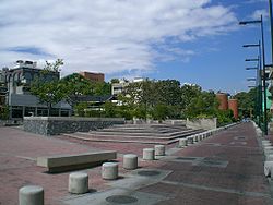
As well as other activities related to national historical celebrations in which is involve the scholastic population through the municipal schools. In Las Mercedes district a series of cultural-musical activities are developed in the Plaza Alfredo Sadel
and the Río de Janeiro avenue, that zones serve as recreation for the community.
, guitar
, and others. In this order of ideas, the "Baruta Festival of the Arts" appears, event that is made with the joint effort of several communities and artistic groups, with the interest to contribute to the cultural development of the municipality during the months of August, September and October.
They are present also cultural institutions like the National Library Independent Institute with two premises: the Raúl Leoni Library located in the Cafetal urbanization, and the public library "Aurelio Alvarez Echezarreta", located in the House of the Culture of Baruta "Oswaldo Perez Perazzo" (Agreement between the Rotary Club and the National Library of Venezuela
).
The Municipality also has, since September 10, 1990 the Athenaeum of Baruta, who is in charge of the diffusion and promotion of the local culture, has like seat the House of the Culture "Oswaldo Perez Perazzo", also at the Baruta town. The municipality also counts since 1997 with the Casa de todos , (House for All), being the seat of the Independent Service of Socioeconomic Development and the Parochial council, it offers permanent attention to community and events for the people of the third age. Baruta has spaces destined to sports and associations, that include an ample range of sport activities, also houses at its downtown near Plaza Bolívar (Bolívar square), the Parochial House and Nuestra Señora del Rosario Church (Our lady of the Rosary), which dates from 1655, undergoing modifications with the years.
Caracas
Caracas , officially Santiago de León de Caracas, is the capital and largest city of Venezuela; natives or residents are known as Caraquenians in English . It is located in the northern part of the country, following the contours of the narrow Caracas Valley on the Venezuelan coastal mountain range...
Municipality in Venezuela
Venezuela
Venezuela , officially called the Bolivarian Republic of Venezuela , is a tropical country on the northern coast of South America. It borders Colombia to the west, Guyana to the east, and Brazil to the south...
. It is located geographically in the South-East section of the city. Its western limit is the Los Chaguaramos neighborhood (which belongs to the Libertador Municipality) and limits to the east with the Colinas de Los Ruices neighborhood, in the Sucre Municipality
Sucre Municipality, Miranda
The Sucre Municipality is one of the 21 municipalities that makes up the Venezuelan state of Miranda and, according to a 2007 population estimate by the National Institute of Statistics of Venezuela, the municipality has a population of 640,762. The city of Petare is the shire town of the Sucre...
. To the North, it borders with the Francisco Fajardo Highway
Francisco Fajardo Highway
The Francisco Fajardo Highway is the most important freeway of Caracas, connecting the west and east sides of the city. The national freeways and many of the avenues of Caracas are not designated with a system of codification or numbering; instead they are designated with the names of historical...
and to the Southeast with the El Hatillo Municipality and to the Southwest with the Hoyo de la Puerta neighborhood (Libertador Municipality).
Although some of the political functions overlap with the Greater Caracas
Caracas
Caracas , officially Santiago de León de Caracas, is the capital and largest city of Venezuela; natives or residents are known as Caraquenians in English . It is located in the northern part of the country, following the contours of the narrow Caracas Valley on the Venezuelan coastal mountain range...
Municipality, Baruta has its own Mayor, Gerardo Blyde. The local government has its own police force, among other responsibilities. The City Hall is currently located in the Bello Monte district, but there are plans for it to be moved to the old Baruta town.
The main economic activity in Baruta is non-manufacturing business in the many office buildings within the Municipality. For example, the Procter & Gamble
Procter & Gamble
Procter & Gamble is a Fortune 500 American multinational corporation headquartered in downtown Cincinnati, Ohio and manufactures a wide range of consumer goods....
Latin American Headquarters are located there. Commerce is also a great source of revenue for the Baruteños, as some of the most attractive night spots in the Greater Caracas are located in Las Mercedes district.
The Baruta Zip Code is 1080 and the Area Code is 212, the same as the Greater Caracas
Caracas
Caracas , officially Santiago de León de Caracas, is the capital and largest city of Venezuela; natives or residents are known as Caraquenians in English . It is located in the northern part of the country, following the contours of the narrow Caracas Valley on the Venezuelan coastal mountain range...
area.
History
The name Baruta was associated with the exuberant vegetation existing in the zone, specifically the Jabillo, that in native language expresses Baruta, which give the name to the caciqueCacique
Cacique is a title derived from the Taíno word for the pre-Columbian chiefs or leaders of tribes in the Bahamas, Greater Antilles, and the northern Lesser Antilles...
and his territory. on March 20, 1568, Diego de Losada
Diego de Losada
Diego de Losada was a Spanish conquistador and the founder of Santiago de León de Caracas, the current capital of Venezuela.Losada was born in Rionegro del Puente, in what is now the province of Zamora. He reached Puerto Rico in 1533....
offers to Captain Alonso Andrea de Ledesma an important mission to located the land and possessions of the Baruta cacique, with the purpose of coverting the Indians to Catholicism, and teaching them to read and to write, as well as to train them in the exercise of the chieftainship. This offer was ratified by the City Hall of Caracas on February 20, 1582, considering this date the beginning of the process of foundation.
On August 19, 1620 Baruta town was founded with the name of "San Francisco de Paula", taking place therefore the first establishment of population of certain importance in the Southeastern part of Caracas
Caracas
Caracas , officially Santiago de León de Caracas, is the capital and largest city of Venezuela; natives or residents are known as Caraquenians in English . It is located in the northern part of the country, following the contours of the narrow Caracas Valley on the Venezuelan coastal mountain range...
. The Governor of the Province st the teim and the Bishop, Francisco de Hoz y Berrío and Fray Gonzalo de Angulo, respectively, decreed to the consecration of the Church of Villa del Rosario de Baruta on July 14, 1655. The great land extensions of the zone were conformed by prosperous properties, whose yield was based on the production of coffee
Coffee
Coffee is a brewed beverage with a dark,init brooo acidic flavor prepared from the roasted seeds of the coffee plant, colloquially called coffee beans. The beans are found in coffee cherries, which grow on trees cultivated in over 70 countries, primarily in equatorial Latin America, Southeast Asia,...
, cane
Sugarcane
Sugarcane refers to any of six to 37 species of tall perennial grasses of the genus Saccharum . Native to the warm temperate to tropical regions of South Asia, they have stout, jointed, fibrous stalks that are rich in sugar, and measure two to six metres tall...
and cacao, as well as alcoholic beverages, sugar
Sugar
Sugar is a class of edible crystalline carbohydrates, mainly sucrose, lactose, and fructose, characterized by a sweet flavor.Sucrose in its refined form primarily comes from sugar cane and sugar beet...
and papelón. La Guairita, Manzanares, La Trinidad and Las Mercedes were great farms, constituting themselves in the origins of the most important urbanizations of the Municipality at the present time. The construction of the road from Caracas to Baruta and the Hatillo took place between 1927 and 1929, giving the urbanizing process in Las Mercedes in the 1940s, and in the 1950s the Municipality begins to experience a great demographic expansion.
In 1961 the Prados del Este Highway was concluded and in 1965 the project of the Universidad Simón Bolívar
Universidad Simón Bolívar
Simón Bolívar University or USB, is a public institution located in Miranda State, Venezuela with scientific and technological orientation....
began in Sartenejas, in the 1960s the urbanizations El Cafetal, Santa Marta, Santa Sofía, San Luis, Santa Paula, Cerro Verde and Los Naranjos were constructed. Baruta was semi-independent until 1954, date in which passes its administration to the Council of Petare, forming part of the extinct Sucre District of the Miranda state
Miranda (state)
Miranda State is one of the 23 states into which Venezuela is divided. It is ranked second in population among Venezuelan states, after Zulia State. In June 30, 2010, it had approximately 2,987,968 residents. It also has the greatest Human Development Index in Venezuela, according to the...
, jointly with Petare, Chacao and El Hatillo. Due to the height and vertiginous growth that the Municipality has confronted, the Legislative Assembly of the Miranda state
Miranda (state)
Miranda State is one of the 23 states into which Venezuela is divided. It is ranked second in population among Venezuelan states, after Zulia State. In June 30, 2010, it had approximately 2,987,968 residents. It also has the greatest Human Development Index in Venezuela, according to the...
declared Baruta like independent Municipality on September 22, 1987. In this sense, their characteristics of socioeconomic and geographic development allowed the creation of the El Hatillo Municipality on January 1992. On April 1992 the parish
Parish
A parish is a territorial unit historically under the pastoral care and clerical jurisdiction of one parish priest, who might be assisted in his pastoral duties by a curate or curates - also priests but not the parish priest - from a more or less central parish church with its associated organization...
of Las Minas de Baruta was created.
Geography
Miranda (state)
Miranda State is one of the 23 states into which Venezuela is divided. It is ranked second in population among Venezuelan states, after Zulia State. In June 30, 2010, it had approximately 2,987,968 residents. It also has the greatest Human Development Index in Venezuela, according to the...
, jointly with other 20 Municipalities. As well, it forms part of the metropolitan area of Caracas
Caracas
Caracas , officially Santiago de León de Caracas, is the capital and largest city of Venezuela; natives or residents are known as Caraquenians in English . It is located in the northern part of the country, following the contours of the narrow Caracas Valley on the Venezuelan coastal mountain range...
next to the Chacao Municipality
Chacao Municipality, Miranda
Chacao Municipality, is one of the five political and administrative subdivisions of the city of Caracas, Venezuela. The other four are Baruta, El Hatillo, Libertador and Sucre. This legal entity is known as the Caracas Metropolitan District...
, Libertador, Sucre and the El Hatillo municipality
El Hatillo Municipality, Miranda
El Hatillo Municipality is an administrative division of the State of Miranda, Venezuela; along with Baruta, Chacao, Libertador and Sucre, it is one of the five municipalities of Caracas, the capital of Venezuela...
. It has a favorable geographic location, acting like integrating element of the Southeastern of Caracas with the rest of the municipalities of the metropolitan area of Caracas. It limits by the North with the municipalities Libertador, Chacao and Sucre, by the East with the municipalities: Sucre, El Hatillo and Paz Castillo by the South with the municipalities Cristóbal Rojas and Guaicaipuro and by the West with the municipality Los Salias and the Libertador Municipality
Libertador Municipality (Venezuelan Capital District)
The Libertador Bolivarian Municipality is the only administrative division of the Venezuelan Capital District and along with the municipalities of Baruta, Chacao, El Hatillo and Sucre forms the Metropolitan District of Caracas. It is located in the western portion of Caracas. It is landlocked by...
of the Capital District.
It has a surface of 9,392, 65 km², representing approximately 14% of the metropolitan area of Caracas. It is important to indicate that of the total area of the municipality, 43% comprise of the Protective Zone of Caracas, which is under the Regime of Special Administration. It is located between the coordinates (UTM - Canoe): (729,900 me - 745,037 me; 1.144.245 mN - 1.160.854 mN)
Climate
The climate is characteristically tropical, with the temperature varying according to the altitude. The annual average temperature is 21.66°C, with a maximum of 28°C during the months of July and August and a minimum of 21°C during the months of December and January, though during months like january and february temperatures can reach 12 degrees in higher zones. According to the classification of Koeppen, the type of climate is savannah (AW). The basic speed of the wind calculated for all the Metropolitan Area of Caracas is of 78 km/h. The annual average precipitation varies between 800 and 1,000 mm3, being greater in the month of July with a period of rain that begins in the month of May and culminates in the month of October. The index average of humidity is of 80%.Vegetation
The predominant vegetation corresponds to a dry forest and a humid forest. Some species of trees can reach 20 meters high, the South and southwestern zone of the Municipality is under the Regime of Special Administration, with the figure of Protective Zone called La Virgen Forest. Other protective zones like El Volcán exist and a part of the Protective Zone of the Metropolitan Area of Caracas.Topography and Relief
The topography appears in rough form, to have a predominantly mountainous relief, whose altitude varies between the 421 m and 1476 m the slopes generally are superior to 45%, although in the rivers appears in 5%. The original topography has been modified through time by the city-planning developments, responding to the necessities of expansion of the city.Hydrography
The hydrography of the Municipality is constituted mainly by two courses of first order as they are the Guaire River to the north of the Municipality and the Guairita river to the east. To the south of the Municipality is the Soapire stream, that represents all the South limit. Between the secondary affluents, that run towards the channels of first order, are the streams: Baruta, Manzanares, Sorokaima, Sartenejas, La Virgen, El Sitio, Canoas, Don Pancho, and El Cafetal, between many others of second and third order of intermittent type, which are activated in the periods of rain. The drainage of the municipality is associated to the particular characteristics of the type of material, the disposition of the layers and the characteristics of the relief.Demographics
- 317,288 inhabitants.
- Density: 2.600 hab. /km².
Parishes
- Nuestra Señora del Rosario de Baruta
- Las Minas de Baruta
- El Cafetal
Law and government
Constitution of Venezuela
||The Constitution of the Bolivarian Republic of Venezuela is the current and twenty-sixth constitution of Venezuela. It was drafted in mid-1999 by a constitutional assembly that had been created by popular referendum. Adopted in December 1999, it replaced the 1961 Constitution - the longest...
specifies that municipal governments be divided into executive
Executive (government)
Executive branch of Government is the part of government that has sole authority and responsibility for the daily administration of the state bureaucracy. The division of power into separate branches of government is central to the idea of the separation of powers.In many countries, the term...
and legislative branches. The executive government of the municipality is governed by the mayor, while the legislative government is managed by the Municipal council. On March 8, 2000, the year after a new constitution was introduced in Venezuela, it was decree
Decree
A decree is a rule of law issued by a head of state , according to certain procedures . It has the force of law...
d in Gaceta Official N° 36,906, that the Metropolitan District of Caracas would be created, and that some of the powers of Baruta would be delegated to the Alcaldía Mayor, which would also start governing the Libertador, Sucre, El Hatillo and Chacao municipalities. Venezuelan municipalities are subdivided in parishes.
Mayors
- Gloria Lizarraga de Capriles (1989–1993)
- Ángel Enrique Zambrano (1993–1996)
- Ivonne Attas (1996–2000)
- Henrique Capriles Radonsky (2000–2008)
- Gerardo Blyde (2008–2012)
Socioeconomics
According to the 1990 Census, 57% of the population of the municipality were economically active. Of the labor force, the feminine population of age to work represents almost 55% of the total of this segment of population. In addition to the indicated particularitity, we found that 43% of the resident population have reached the secondary level of studies, determining that the illiteracy index is one of lowest of the Metropolitan Zone, being of a 2.03% for the population of 15 years and more, for the population between 5 and 14 years the index is of 1.76%. The educative indices of the population place to the Baruta Municipality in a privileged situation forehead to other localities of the capital and the country. If we inferred statistically we found that only a 1.34% of the greater population of 15 years are without no educative level and a 3.95% for the included one between 5 and 14 years. It is observed that the Municipality for being a zone of residential use, has a high index of occupied houses (86%). According to the percentage presented by the OCEI in 1990, the buildings predominate with a 59% with respect to the total of houses, villas with a 20.39% and houses with a 16.63%.Low indices of construction of shanty towns, locating themselves in 3% approximately.
Culture
In the Municipality diverse cultural manifestations are developed, some associates to popular celebrations, like:- Day of the Candlemas (Paradura del niño), Date of celebration: February 2.
- Carnival, Date of celebration: movable.
- Holy week, Date of celebration: movable.
- The cross of May, Date of celebration: May 3.
- Saint AnthonyAnthony of PaduaAnthony of Padua or Anthony of Lisbon, O.F.M., was a Portuguese Catholic priest and friar of the Franciscan Order. Though he died in Padua, Italy, he was born to a wealthy family in Lisbon, Portugal, which is where he was raised...
, Date of celebration: June 13. - Saint JohnJohn the BaptistJohn the Baptist was an itinerant preacher and a major religious figure mentioned in the Canonical gospels. He is described in the Gospel of Luke as a relative of Jesus, who led a movement of baptism at the Jordan River...
, Date of celebration: June 24. - Day of Our Lady of the RosaryOur Lady of the RosaryOur Lady of the Rosary is a title of the Blessed Virgin Mary in relation to the rosary....
of Baruta (Month of Baruta), Date of celebration: October 29. - Day of Our Lady of FatimaOur Lady of FatimaOur Lady of Fátima is a famous title given to the Blessed Virgin Mary as she appeared in apparitions reported by three shepherd children at Fátima in Portugal. These occurred on the 13th day of six consecutive months in 1917, starting on May 13...
(Las Minas and Monterrey), Date of celebration: October 30.
As well as other activities related to national historical celebrations in which is involve the scholastic population through the municipal schools. In Las Mercedes district a series of cultural-musical activities are developed in the Plaza Alfredo Sadel
Alfredo Sadel
Alfredo Sadel was a popular Venezuelan singer and actor. Born Alfredo Sánchez Luna in Caracas, Venezuela, Sadel was affectionately called "The Favorite Tenor of Venezuela" . He adopted his stage name by combining the first syllable of his surname with the last syllable of the surname of his...
and the Río de Janeiro avenue, that zones serve as recreation for the community.
Cultural institutions
At the House of the Culture of Baruta "Oswaldo Perez Perazzo" a cultural and educative work stands out directed to the population of limited resources by means of the execution of specific programs on the part of the Independent Service of Art and Culture of the Baruta Municipality, such as: infantile and youthful painting, enamels on metal, ceramics, painting on porcelain, engraving, weave and embroidering, factories of dance, theater, courses of ballet, folklore, corporal expression, flamenco, choral factories of pop music, retreats, classes of cuatroCuatro (instrument)
The cuatro is any of several Latin American instruments of the guitar or lute family. The cuatro is smaller than a guitar. Cuatro means four in Spanish, although current instruments may have more than four strings....
, guitar
Guitar
The guitar is a plucked string instrument, usually played with fingers or a pick. The guitar consists of a body with a rigid neck to which the strings, generally six in number, are attached. Guitars are traditionally constructed of various woods and strung with animal gut or, more recently, with...
, and others. In this order of ideas, the "Baruta Festival of the Arts" appears, event that is made with the joint effort of several communities and artistic groups, with the interest to contribute to the cultural development of the municipality during the months of August, September and October.
They are present also cultural institutions like the National Library Independent Institute with two premises: the Raúl Leoni Library located in the Cafetal urbanization, and the public library "Aurelio Alvarez Echezarreta", located in the House of the Culture of Baruta "Oswaldo Perez Perazzo" (Agreement between the Rotary Club and the National Library of Venezuela
National Library of Venezuela
Biblioteca Nacional de Venezuela , is a central repository of books and newspapers of Venezuela, has the right to receive a copy of every book printed in Venezuela by a Venezuelan publisher. It collects books and magazines published in the country. It was established in Caracas in 1833...
).
The Municipality also has, since September 10, 1990 the Athenaeum of Baruta, who is in charge of the diffusion and promotion of the local culture, has like seat the House of the Culture "Oswaldo Perez Perazzo", also at the Baruta town. The municipality also counts since 1997 with the Casa de todos , (House for All), being the seat of the Independent Service of Socioeconomic Development and the Parochial council, it offers permanent attention to community and events for the people of the third age. Baruta has spaces destined to sports and associations, that include an ample range of sport activities, also houses at its downtown near Plaza Bolívar (Bolívar square), the Parochial House and Nuestra Señora del Rosario Church (Our lady of the Rosary), which dates from 1655, undergoing modifications with the years.
See also
- Miranda State
- CaracasCaracasCaracas , officially Santiago de León de Caracas, is the capital and largest city of Venezuela; natives or residents are known as Caraquenians in English . It is located in the northern part of the country, following the contours of the narrow Caracas Valley on the Venezuelan coastal mountain range...
- MunicipalityMunicipalityA municipality is essentially an urban administrative division having corporate status and usually powers of self-government. It can also be used to mean the governing body of a municipality. A municipality is a general-purpose administrative subdivision, as opposed to a special-purpose district...
- Venezuelan Capital DistrictVenezuelan Capital DistrictThe Capital District of Venezuela is a federal district corresponding to the capital Caracas. It has an area of 433 km² and there is only one administrative division , Libertador, which contains about half City of Caracas. It is the seat of the federal government and the head of the public...