Barrett Reef
Encyclopedia
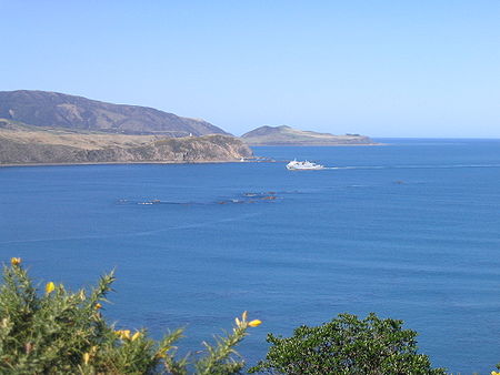
The cluster of rocks that is Barrett Reef (often known as Barrett's Reef) is one of the most treacherous reef
s in New Zealand
.
It lies on the western side of the entrance of Wellington Harbour
, on the approaches to the city of Wellington
, at coordinates . The reef is named after Richard (Dicky) Barrett
(1807-1847), a whaler and trader. Its Maori
name is Tangihanga-a-Kupe. It is popular with recreational underwater divers.
 The reef, much of which is exposed even at high tide, is located to the west of the two-kilometre-wide channel that links Cook Strait
with Wellington Harbour, close to the shore of the Miramar Peninsula
. Due to the channelling effect of Cook Strait, which lies between the Pacific Ocean
and the Tasman Sea
, the currents are strong and fickle and gales are common. Add to this the volume of traffic which uses the channel (including several crossings daily of the inter-island ferries to Picton
), and it is not surprising that the reef has a lengthy roll-call of shipwreck
s.
Reef
In nautical terminology, a reef is a rock, sandbar, or other feature lying beneath the surface of the water ....
s in New Zealand
New Zealand
New Zealand is an island country in the south-western Pacific Ocean comprising two main landmasses and numerous smaller islands. The country is situated some east of Australia across the Tasman Sea, and roughly south of the Pacific island nations of New Caledonia, Fiji, and Tonga...
.
It lies on the western side of the entrance of Wellington Harbour
Wellington Harbour
Wellington Harbour is the large natural harbour at the southern tip of New Zealand's North Island. New Zealand's capital, Wellington, is on the western side of Wellington Harbour. The harbour was officially named Port Nicholson until it assumed its current name in the 1980s.In Māori the harbour is...
, on the approaches to the city of Wellington
Wellington
Wellington is the capital city and third most populous urban area of New Zealand, although it is likely to have surpassed Christchurch due to the exodus following the Canterbury Earthquake. It is at the southwestern tip of the North Island, between Cook Strait and the Rimutaka Range...
, at coordinates . The reef is named after Richard (Dicky) Barrett
Dicky Barrett (trader)
Richard "Dicky" Barrett was one of the first white traders to be based in New Zealand. He lent his translation skills to help negotiate the first land purchases from Maori in New Plymouth and Wellington and became a key figure in the establishment of the settlement of New Plymouth...
(1807-1847), a whaler and trader. Its Maori
Maori language
Māori or te reo Māori , commonly te reo , is the language of the indigenous population of New Zealand, the Māori. It has the status of an official language in New Zealand...
name is Tangihanga-a-Kupe. It is popular with recreational underwater divers.
Dangerous entrance

Cook Strait
Cook Strait is the strait between the North and South Islands of New Zealand. It connects the Tasman Sea on the west with the South Pacific Ocean on the east....
with Wellington Harbour, close to the shore of the Miramar Peninsula
Miramar Peninsula
The Miramar Peninsula is a peninsula at the southeastern end of the city of Wellington, New Zealand.The peninsula is 800 hectares and contains the suburbs of Miramar, Maupuia, Strathmore and Seatoun...
. Due to the channelling effect of Cook Strait, which lies between the Pacific Ocean
Pacific Ocean
The Pacific Ocean is the largest of the Earth's oceanic divisions. It extends from the Arctic in the north to the Southern Ocean in the south, bounded by Asia and Australia in the west, and the Americas in the east.At 165.2 million square kilometres in area, this largest division of the World...
and the Tasman Sea
Tasman Sea
The Tasman Sea is the large body of water between Australia and New Zealand, approximately across. It extends 2,800 km from north to south. It is a south-western segment of the South Pacific Ocean. The sea was named after the Dutch explorer Abel Janszoon Tasman, the first recorded European...
, the currents are strong and fickle and gales are common. Add to this the volume of traffic which uses the channel (including several crossings daily of the inter-island ferries to Picton
Picton, New Zealand
Picton is a town in the Marlborough region of New Zealand. It is close to the head of Queen Charlotte Sound near the north-east corner of the South Island. The population was 2928 in the 2006 Census, a decrease of 72 from 2001...
), and it is not surprising that the reef has a lengthy roll-call of shipwreck
Shipwreck
A shipwreck is what remains of a ship that has wrecked, either sunk or beached. Whatever the cause, a sunken ship or a wrecked ship is a physical example of the event: this explains why the two concepts are often overlapping in English....
s.
History of vessels damaged, stranded, or wrecked on Barrett Reef
- 1866 Tui, iron steamer. Wrecked, north end of Barrett Reef
- 1871 Lady Bird, schooner (3-masted), 303 tons
- 1874 Earl of South Esk, wooden barque, 336 tons
- 1874 Cynthia, schooner, 63 tons. Stranded; partial loss. Abreast of north end of Barrett Reef
- 1876 Hunter, schooner, 90 tons. Stranded; total loss. Southernmost rock of Barrett Reef
- 1876 Shepherdess, schooner, 38 tons, Stranded; partial loss
- 1921 Polly Woodside, three-masted iron barque, 678 tons. Stranded; refloated and repaired.
- 1927 Norma
- 1936 Rangatira, inter-island ferry, 6,152 tons http://www.nzmaritime.co.nz/r301.htm
- 1947 WanganellaWanganellaWanganella was an Australian-registered merchant vessel constructed by the Harland and Wolff shipyards and entering service as a trans-Tasman passenger liner in 1933...
liner, 9576 tons. Stranded; refloated and repaired. - 1968 WahineWahine disasterThe Wahine disaster occurred on 10 April 1968 when the TEV Wahine, a New Zealand inter-island ferry of the Union Company, foundered on Barrett Reef at the entrance to Wellington Harbour and capsized near Steeple Rock...
, inter-island ferry, 8,948 tons, 53 lives lost. Wrecked; complete loss.

