
Barnham, West Sussex
Encyclopedia
Barnham is a large village and civil parish
in the Arun
district of West Sussex
, England
, about five miles (8 km) north of Bognor Regis
. The civil parish had a population of 1,270 persons according to the 1991 census, although the adjacent area of 'West Barnham' (actually in the parish of Eastergate - see below) adds a further 3,107 (2001 census) to the total. The village covers an area of 373.3ha. As with many other such villages in the south-east of England, there are plans for many more houses to be built, mostly retirement apartments for the elderly.
Barnham is mentioned in the Domesday Book
and the cattle market (founded in 1890 but now long gone) was, in its heyday, considered to be one of the most important in Sussex for both cattle and cereals.
In the 20th century this area, on alluvial soils
, was important for market gardening
; There are many large, industrial-sized greenhouse
s in the area, although very few actually within the parish boundary.
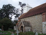
The parish church, dedicated to St Mary, was given to the Abbey of Lessay in Normandy in 1105 and later passed to Boxgrove Priory
. There is an elaborate carved rectangular font of Sussex marble
. The white wooden tower was once regarded as an important aid to shipping in the English Channel
.
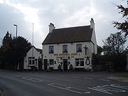 There were two public house
s in the village until 2010, The Barnham Bridge Inn and the Murrell Arms - originally a farmhouse, built in 1750, and licensed since 1866. In 2010 The Barnham Bridge Inn closed when the brewery was taken into administration. The building remains, and the letting rooms are still occupied. The pub part of The Barnham Bridge Inn has remained closed in 2011.
Barnham Windmill
lies on the South-Eastern boundary of the village on the road to Yapton
. The present windmill was built in 1829 and has undergone start-and-stop restoration for over a decade although there seems to have been little work done since 2007. The windmill used to be accessible through the adjacent tea rooms (albeit in a rather 'at your own risk', unofficial manner!), but when the tea rooms closed in 2005 so did access to the mill. In August 2009, work began to turn the tea rooms and adjacent property into a total of 5 dwellings, with the provisional development plans stating that the windmill would be turned into a '4/5 bedroom house'.
Part of the Portsmouth-Arundel Canal (opened in 1823 but now disused and filled in) are visible to the SE of the village, including remains of the locks and pivots used for the locking mechanisms.
Barnham's railway bridge is occasionally hit by high vehicles. In March 2007, a double decker bus, travelling into the village from Yapton
, attempted passage under the bridge with the resultant removal of its top deck. Luckily, no-one was hurt.
Aesthetically, the village has little to offer. For accessibility and commuting to London however, as well as being convenient for the coast, the Downs, and places like Chichester and Arundel, its location makes it very popular, and homes in the village are in great demand.
were built approximately one mile north of the church, the entire focus of the village shifted as businesses built premises adjacent to the station and this was followed by housing developments centred on this location. Soon, the area around the station took the 'feel' of the village centre. This shift generally explains why many features and facilities considered to be part of 'Barnham' are, in fact, in the parish of Eastergate. The postal district of Barnham is also based on this mindset and so many addresses in an area officially known as 'West Barnham' (a nomenclature not generally used by the locals) are actually in Eastergate parish.
Civil parish
In England, a civil parish is a territorial designation and, where they are found, the lowest tier of local government below districts and counties...
in the Arun
Arun
Arun is a local government district in West Sussex, England. It contains the towns of Arundel, Bognor Regis and Littlehampton, and takes its name from the River Arun, which runs through the centre of the district.-History:...
district of West Sussex
West Sussex
West Sussex is a county in the south of England, bordering onto East Sussex , Hampshire and Surrey. The county of Sussex has been divided into East and West since the 12th century, and obtained separate county councils in 1888, but it remained a single ceremonial county until 1974 and the coming...
, England
England
England is a country that is part of the United Kingdom. It shares land borders with Scotland to the north and Wales to the west; the Irish Sea is to the north west, the Celtic Sea to the south west, with the North Sea to the east and the English Channel to the south separating it from continental...
, about five miles (8 km) north of Bognor Regis
Bognor Regis
Bognor Regis is a seaside resort town and civil parish in the Arun district of West Sussex, on the south coast of England. It is south-south-west of London, west of Brighton, and south-east of the city of Chichester. Other nearby towns include Littlehampton east-north-east and Selsey to the...
. The civil parish had a population of 1,270 persons according to the 1991 census, although the adjacent area of 'West Barnham' (actually in the parish of Eastergate - see below) adds a further 3,107 (2001 census) to the total. The village covers an area of 373.3ha. As with many other such villages in the south-east of England, there are plans for many more houses to be built, mostly retirement apartments for the elderly.
Barnham is mentioned in the Domesday Book
Domesday Book
Domesday Book , now held at The National Archives, Kew, Richmond upon Thames in South West London, is the record of the great survey of much of England and parts of Wales completed in 1086...
and the cattle market (founded in 1890 but now long gone) was, in its heyday, considered to be one of the most important in Sussex for both cattle and cereals.
In the 20th century this area, on alluvial soils
Alluvium
Alluvium is loose, unconsolidated soil or sediments, eroded, deposited, and reshaped by water in some form in a non-marine setting. Alluvium is typically made up of a variety of materials, including fine particles of silt and clay and larger particles of sand and gravel...
, was important for market gardening
Market gardening
A market garden is the relatively small-scale production of fruits, vegetables and flowers as cash crops, frequently sold directly to consumers and restaurants. It is distinguishable from other types of farming by the diversity of crops grown on a small area of land, typically, from under one acre ...
; There are many large, industrial-sized greenhouse
Greenhouse
A greenhouse is a building in which plants are grown. These structures range in size from small sheds to very large buildings...
s in the area, although very few actually within the parish boundary.
The parish church, dedicated to St Mary, was given to the Abbey of Lessay in Normandy in 1105 and later passed to Boxgrove Priory
Boxgrove Priory
Boxgrove Priory, in the village of Boxgrove in Sussex, was founded in about 1066 by Robert de Haye, who in 1105 bestowed the church of St. Mary of Boxgrove upon the Benedictine Abbey of Lessay. In about 1126 upon the marriage of Robert's daughter Cecily, to Roger St...
. There is an elaborate carved rectangular font of Sussex marble
Sussex Marble
West Sussex has a good concentration of relatively thin layers of Sussex Marble within the Weald Clay, a freshwater limestone referred to as "marble" as it takes a polish. It is not a geologically described one as it has not been subject to metamorphosis...
. The white wooden tower was once regarded as an important aid to shipping in the English Channel
English Channel
The English Channel , often referred to simply as the Channel, is an arm of the Atlantic Ocean that separates southern England from northern France, and joins the North Sea to the Atlantic. It is about long and varies in width from at its widest to in the Strait of Dover...
.
Public house
A public house, informally known as a pub, is a drinking establishment fundamental to the culture of Britain, Ireland, Australia and New Zealand. There are approximately 53,500 public houses in the United Kingdom. This number has been declining every year, so that nearly half of the smaller...
s in the village until 2010, The Barnham Bridge Inn and the Murrell Arms - originally a farmhouse, built in 1750, and licensed since 1866. In 2010 The Barnham Bridge Inn closed when the brewery was taken into administration. The building remains, and the letting rooms are still occupied. The pub part of The Barnham Bridge Inn has remained closed in 2011.
Barnham Windmill
John Baker's Mill, Barnham
John Baker's Mill is a grade II listed tower mill at Barnham, Sussex, England which was under restoration and is now to be converted to residential use.-History:...
lies on the South-Eastern boundary of the village on the road to Yapton
Yapton
Yapton is a village and civil parish in the Arun District of West Sussex, England. It is three miles to the north-west of Bognor Regis at the intersection of the B2132 and B2233 roads...
. The present windmill was built in 1829 and has undergone start-and-stop restoration for over a decade although there seems to have been little work done since 2007. The windmill used to be accessible through the adjacent tea rooms (albeit in a rather 'at your own risk', unofficial manner!), but when the tea rooms closed in 2005 so did access to the mill. In August 2009, work began to turn the tea rooms and adjacent property into a total of 5 dwellings, with the provisional development plans stating that the windmill would be turned into a '4/5 bedroom house'.
Part of the Portsmouth-Arundel Canal (opened in 1823 but now disused and filled in) are visible to the SE of the village, including remains of the locks and pivots used for the locking mechanisms.
Barnham's railway bridge is occasionally hit by high vehicles. In March 2007, a double decker bus, travelling into the village from Yapton
Yapton
Yapton is a village and civil parish in the Arun District of West Sussex, England. It is three miles to the north-west of Bognor Regis at the intersection of the B2132 and B2233 roads...
, attempted passage under the bridge with the resultant removal of its top deck. Luckily, no-one was hurt.
Aesthetically, the village has little to offer. For accessibility and commuting to London however, as well as being convenient for the coast, the Downs, and places like Chichester and Arundel, its location makes it very popular, and homes in the village are in great demand.
Eastergate or Barnham?
St Mary's Church represents the heart of 'Old Barnham', but when the railway station and junction for Bognor RegisBognor Regis
Bognor Regis is a seaside resort town and civil parish in the Arun district of West Sussex, on the south coast of England. It is south-south-west of London, west of Brighton, and south-east of the city of Chichester. Other nearby towns include Littlehampton east-north-east and Selsey to the...
were built approximately one mile north of the church, the entire focus of the village shifted as businesses built premises adjacent to the station and this was followed by housing developments centred on this location. Soon, the area around the station took the 'feel' of the village centre. This shift generally explains why many features and facilities considered to be part of 'Barnham' are, in fact, in the parish of Eastergate. The postal district of Barnham is also based on this mindset and so many addresses in an area officially known as 'West Barnham' (a nomenclature not generally used by the locals) are actually in Eastergate parish.