

Bannered routes of U.S. Route 52
Encyclopedia
Several bannered routes of U.S. Route 52
exist, from North Dakota
to South Carolina
. In order from northwest to southeast, separated by type, they are as follows.
in Harvey
, North Dakota
. It runs from U.S. Route 52
in Harvey
to U.S. Route 52
/North Dakota Highway 3
.
 U.S. Route 52 Spur is an unsigned 2.98 miles (4.8 km) long spur of U.S. Route 52
in Charleston
, South Carolina
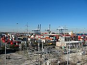
. It extends from U.S. Route 52 (where it is named Meeting Street) to Broad Street along the northeastern side of the peninsula of downtown Charleston. The route provides access for trucks to shipping terminals of the port on the Charleston peninsula: Union Pier and Columbus Street.
The entire route is in the city of Charleston
. 1.29 miles (2.1 km) of the route is named Morrison Drive and the remaining 1.69 miles (2.7 km) is named East Bay Street.
One section of the route, Morrison Drive near Jackson Street, will flood regularly during a spring tide. The eastern terminus is near the historic wharves of Charleston, including Adgers Wharf, which is now the site of a playground. It is also adjacent to the old Exchange, or Customs House, of Charleston. The current Customs House that was built around the time of the Civil War
is on this route.
When Morrison Drive was constructed, there was still one private terminal operating near the Eastern terminus, the Clydeline Steamship Company. The Clydeline terminal burned down in 1955. In the late 80s, the land of the terminal was rebuilt as Charleston Waterfront Park.
U.S. Route 52
U.S. Route 52 is a United States highway that runs across the northern, eastern and southeastern regions of the United States. Contrary to most other even-numbered U.S...
exist, from North Dakota
North Dakota
North Dakota is a state located in the Midwestern region of the United States of America, along the Canadian border. The state is bordered by Canada to the north, Minnesota to the east, South Dakota to the south and Montana to the west. North Dakota is the 19th-largest state by area in the U.S....
to South Carolina
South Carolina
South Carolina is a state in the Deep South of the United States that borders Georgia to the south, North Carolina to the north, and the Atlantic Ocean to the east. Originally part of the Province of Carolina, the Province of South Carolina was one of the 13 colonies that declared independence...
. In order from northwest to southeast, separated by type, they are as follows.
Harvey business loop
U.S. Route 52 Business is an 2 miles (3.2 km) long bannered route of U.S. Route 52U.S. Route 52
U.S. Route 52 is a United States highway that runs across the northern, eastern and southeastern regions of the United States. Contrary to most other even-numbered U.S...
in Harvey
Harvey, North Dakota
As of the census of 2000, there were 1,989 people, 926 households, and 529 families residing in the city. The population density was 1,031.8 people per square mile . There were 1,056 housing units at an average density of 547.8 per square mile...
, North Dakota
North Dakota
North Dakota is a state located in the Midwestern region of the United States of America, along the Canadian border. The state is bordered by Canada to the north, Minnesota to the east, South Dakota to the south and Montana to the west. North Dakota is the 19th-largest state by area in the U.S....
. It runs from U.S. Route 52
U.S. Route 52
U.S. Route 52 is a United States highway that runs across the northern, eastern and southeastern regions of the United States. Contrary to most other even-numbered U.S...
in Harvey
Harvey, North Dakota
As of the census of 2000, there were 1,989 people, 926 households, and 529 families residing in the city. The population density was 1,031.8 people per square mile . There were 1,056 housing units at an average density of 547.8 per square mile...
to U.S. Route 52
U.S. Route 52
U.S. Route 52 is a United States highway that runs across the northern, eastern and southeastern regions of the United States. Contrary to most other even-numbered U.S...
/North Dakota Highway 3
North Dakota Highway 3
North Dakota Highway 3 is a major north–south highway in North Dakota. It runs from Manitoba Highway 10 at the International Peace Garden to South Dakota Highway 45 south of Ashley.-Major Junctions:*I-94 at exit 200 and running concurrent to exit 208...
.
Minot business loop
Ironton business loop
Mount Airy business loop
U.S. Route 52 Business was established in 1960, a renumbering of US 52A through downtown Mount Airy, via Main Street, Renfro Street, and Lebanon Street. Between 1963–1967, US 52 Business was split on one-way streets: northbound via Cherry and Renfro Streets, southbound via Main Street. Sometime between 1969–1972, southbound US 52 Business was removed from Main and Cherry Streets, and moved onto an extended Renfro Street.Albemarle business loop
U.S. Route 52 Business was established in the mid-1990s, it goes through downtown Albemarle, via First Street.Darlington business loop
Charleston spur route
U.S. Route 52
U.S. Route 52 is a United States highway that runs across the northern, eastern and southeastern regions of the United States. Contrary to most other even-numbered U.S...
in Charleston
Charleston, South Carolina
Charleston is the second largest city in the U.S. state of South Carolina. It was made the county seat of Charleston County in 1901 when Charleston County was founded. The city's original name was Charles Towne in 1670, and it moved to its present location from a location on the west bank of the...
, South Carolina
South Carolina
South Carolina is a state in the Deep South of the United States that borders Georgia to the south, North Carolina to the north, and the Atlantic Ocean to the east. Originally part of the Province of Carolina, the Province of South Carolina was one of the 13 colonies that declared independence...
. It extends from U.S. Route 52 (where it is named Meeting Street) to Broad Street along the northeastern side of the peninsula of downtown Charleston. The route provides access for trucks to shipping terminals of the port on the Charleston peninsula: Union Pier and Columbus Street.
The entire route is in the city of Charleston
Charleston, South Carolina
Charleston is the second largest city in the U.S. state of South Carolina. It was made the county seat of Charleston County in 1901 when Charleston County was founded. The city's original name was Charles Towne in 1670, and it moved to its present location from a location on the west bank of the...
. 1.29 miles (2.1 km) of the route is named Morrison Drive and the remaining 1.69 miles (2.7 km) is named East Bay Street.
One section of the route, Morrison Drive near Jackson Street, will flood regularly during a spring tide. The eastern terminus is near the historic wharves of Charleston, including Adgers Wharf, which is now the site of a playground. It is also adjacent to the old Exchange, or Customs House, of Charleston. The current Customs House that was built around the time of the Civil War
American Civil War
The American Civil War was a civil war fought in the United States of America. In response to the election of Abraham Lincoln as President of the United States, 11 southern slave states declared their secession from the United States and formed the Confederate States of America ; the other 25...
is on this route.
History
The section named Morrison Drive was constructed in the early 1950s. It was named for William McG. Morrison, mayor of Charleston from 1953 to 1954.When Morrison Drive was constructed, there was still one private terminal operating near the Eastern terminus, the Clydeline Steamship Company. The Clydeline terminal burned down in 1955. In the late 80s, the land of the terminal was rebuilt as Charleston Waterfront Park.