
Aydon
Encyclopedia
Aydon is a village in Northumberland
Northumberland
Northumberland is the northernmost ceremonial county and a unitary district in North East England. For Eurostat purposes Northumberland is a NUTS 3 region and is one of three boroughs or unitary districts that comprise the "Northumberland and Tyne and Wear" NUTS 2 region...
, England
England
England is a country that is part of the United Kingdom. It shares land borders with Scotland to the north and Wales to the west; the Irish Sea is to the north west, the Celtic Sea to the south west, with the North Sea to the east and the English Channel to the south separating it from continental...
. It is about 2 miles (3 km) northeast of Corbridge
Corbridge
Corbridge is a village in Northumberland, England, situated west of Newcastle and east of Hexham. Villages in the vicinity include Halton, Acomb, Aydon and Sandhoe.-Roman fort and town:...
on the B6321 road. The village is about 18 miles (29 km) from Newcastle along the main A69 road
A69 road
The A69 is a major road in northern England, running east-west across the Pennines, through the counties of Tyne and Wear, Northumberland and Cumbria. Originally the road started in Blaydon, but since the creation of the A1 Western Bypass around Newcastle upon Tyne, it now starts at Denton Burn a...
. The A68 road
A68 road
The A68 is a major road in the United Kingdom, running from Darlington in England to the A720 in Scotland.From Darlington, the road runs north, bypassing Bishop Auckland, and running through West Auckland, Toft Hill and Tow Law, past Consett and Corbridge...
is close by, leading to Jedburgh
Jedburgh
Jedburgh is a town and former royal burgh in the Scottish Borders and historically in Roxburghshire.-Location:Jedburgh lies on the Jed Water, a tributary of the River Teviot, it is only ten miles from the border with England and is dominated by the substantial ruins of Jedburgh Abbey...
and Darlington
Darlington
Darlington is a market town in the Borough of Darlington, part of the ceremonial county of County Durham, England. It lies on the small River Skerne, a tributary of the River Tees, not far from the main river. It is the main population centre in the borough, with a population of 97,838 as of 2001...
. Aydon lies near the course of the ancient Roman monument, Hadrian's Wall
Hadrian's Wall
Hadrian's Wall was a defensive fortification in Roman Britain. Begun in AD 122, during the rule of emperor Hadrian, it was the first of two fortifications built across Great Britain, the second being the Antonine Wall, lesser known of the two because its physical remains are less evident today.The...
.
Landmarks
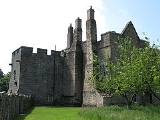
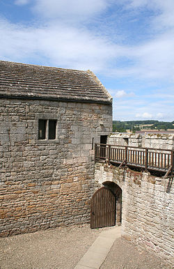
Aydon Castle is a fortified manor houseManor house
A manor house is a country house that historically formed the administrative centre of a manor, the lowest unit of territorial organisation in the feudal system in Europe. The term is applied to country houses that belonged to the gentry and other grand stately homes...
and is a Scheduled Ancient Monument
Scheduled Ancient Monument
In the United Kingdom, a scheduled monument is a 'nationally important' archaeological site or historic building, given protection against unauthorized change. The various pieces of legislation used for legally protecting heritage assets from damage and destruction are grouped under the term...
and a Grade I listed building. The manor house was built by Robert de Reymes, a wealthy Suffolk
Suffolk
Suffolk is a non-metropolitan county of historic origin in East Anglia, England. It has borders with Norfolk to the north, Cambridgeshire to the west and Essex to the south. The North Sea lies to the east...
merchant, starting in 1296, adjacent to the steep valley of the Cor Burn. At this time the house consisted of a two-storeyed home with a solar, dining hall and kitchen on the upper floor. In 1305 he obtained a licence to crenellate his property and added battlements and curtain walls. In the middle of the 16th century it was renovated and in the middle of 17th century it was converted into a farm. The building remained in use as a farm until 1966 but has since been restored to its mediæval appearance.