

Avon Valley Path
Encyclopedia
Wiltshire
Wiltshire is a ceremonial county in South West England. It is landlocked and borders the counties of Dorset, Somerset, Hampshire, Gloucestershire, Oxfordshire and Berkshire. It contains the unitary authority of Swindon and covers...
, Hampshire
Hampshire
Hampshire is a county on the southern coast of England in the United Kingdom. The county town of Hampshire is Winchester, a historic cathedral city that was once the capital of England. Hampshire is notable for housing the original birthplaces of the Royal Navy, British Army, and Royal Air Force...
and (for about 2½ miles) Dorset
Dorset
Dorset , is a county in South West England on the English Channel coast. The county town is Dorchester which is situated in the south. The Hampshire towns of Bournemouth and Christchurch joined the county with the reorganisation of local government in 1974...
.
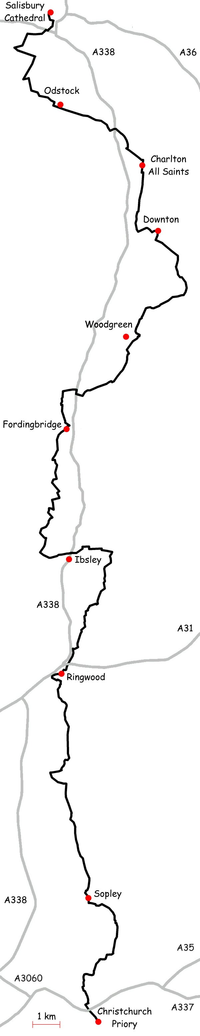
The path takes its name from the River Avon
River Avon, Hampshire
The River Avon is a river in the south of England. The river rises in the county of Wiltshire and flows through the city of Salisbury and the county of Hampshire before reaching the English Channel through Christchurch Harbour in the county of Dorset....
. From Salisbury
Salisbury
Salisbury is a cathedral city in Wiltshire, England and the only city in the county. It is the second largest settlement in the county...
it passes through the towns of Downton, Fordingbridge
Fordingbridge
Fordingbridge is a town and civil parish with a population of 5,700 on the River Avon in the New Forest District of Hampshire, England, near to the Dorset and Wiltshire borders and on the edge of the New Forest. It is south west of London, and south of the city of Salisbury. Fordingbridge is a...
and Ringwood
Ringwood
Ringwood is a historic market town and civil parish in Hampshire, England, located on the River Avon, close to the New Forest and north of Bournemouth. It has a history dating back to Anglo-Saxon times, and has held a weekly market since the Middle Ages....
as well as the villages of Odstock
Odstock
Odstock is a village and civil parish about south of Salisbury in Wiltshire, England.In the woods about Odstock are earthworks. The meaning of the name is probably "Odo's stockade".Odstock's parish population was 118 in 1801, 158 in 1901 and 535 in 1971...
, Nunton, Charlton-All-Saints
Charlton-All-Saints
Charlton-All-Saints, Wiltshire SP5 is a village immediately to the west of the River Avon in Wiltshire, about south of Salisbury. The village is in the civil parish of Downton.The village has existed since Saxon times...
, Hale
Hale, Hampshire
Hale is a small village and civil parish in Hampshire, England. It lies on the border of the New Forest, overlooking the valley of the River Avon. The village is about north-east of the town of Fordingbridge, and about south of the city of Salisbury...
, Woodgreen
Woodgreen
Woodgreen is a village and civil parish within the New Forest district of Hampshire in England.-Overview:Woodgreen lies between Breamore and Hale to the east of the River Avon. It is located due south of the city of Salisbury, its nearest town is Fordingbridge lying to the southwest. In the 2001 UK...
, Turmer
Turmer
Turmer is a small hamlet near Harbridge in Hampshire, England. It lies within the civil parish of Ellingham, Harbridge and Ibsley.Turmer is unusual for a settlement in England. No paved roads reach the hamlet, and traditional farming techniques, including heavy horses, are still used there. It...
, Ibsley
Ibsley
Ibsley is a village in Hampshire, England. It is about 2.5 miles north of the town of Ringwood.-Overview:The village of Ibsley lies to the east of the River Avon on the main road between Ringwood and Fordingbridge, and has some picturesque thatched cottages...
, Kingston and Sopley
Sopley
Sopley is a village and civil parish situated in the New Forest National Park of Hampshire, England. It lies on the old main road from Christchurch to Ringwood, on the east bank of the River Avon. The Parish extends east as far as Thorny Hill and borders the parishes of Bransgore and Burton to the...
. It ends at Christchurch
Christchurch, Dorset
Christchurch is a borough and town in the county of Dorset on the south coast of England. The town adjoins Bournemouth in the west and the New Forest lies to the east. Historically in Hampshire, it joined Dorset with the reorganisation of local government in 1974 and is the most easterly borough in...
.
The path is waymarked
Waymarking
Waymarking is an activity where people locate and log interesting locations around the world, usually with a GPS receiver and a digital camera. Waymarking differs from geocaching in that there is no physical container to locate at the given coordinates. Waymarking identifies points of interest for...
and can be walked in either direction. The path crosses the Clarendon Way
Clarendon Way
The Clarendon Way is a recreational footpath in England. It starts beside the waters of the River Itchen in the centre of Winchester and ends near the River Avon at Salisbury Cathedral. The path passes through the Clarendon Estate and close to the 12th century ruins of Clarendon Palace...
and Castleman Trailway
Castleman Trailway
The Castleman Trailway is a footpath in Southern England. Portions of the trailway are also a cyclepath but the middle section from West Moors to Wimborne is not cyclable....
. It passes through the western edge of the New Forest
New Forest
The New Forest is an area of southern England which includes the largest remaining tracts of unenclosed pasture land, heathland and forest in the heavily-populated south east of England. It covers south-west Hampshire and extends into south-east Wiltshire....
.
This route is shown as a series of coloured diamonds on Ordnance Survey 1:25,000 and 1:50,000 maps.