
Clarendon Way
Encyclopedia
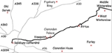
The Clarendon Way is a recreational footpath
in England
. It starts beside the waters of the River Itchen
in the centre of Winchester
and ends near the River Avon
at Salisbury Cathedral
. The path passes through the Clarendon Estate and close to the 12th century ruins of Clarendon Palace
. The path also passes through Farley Mount Country Park and the villages of Pitton
, The Winterslows
, Broughton
and King's Somborne
.
The footpath is waymarked
by metal and plastic disks found attached to wooden and metal posts, trees and street furniture. This route is shown as a series of green diamonds on Ordnance Survey
1:25,000 maps and as a series of red diamonds on Ordnance Survey 1:50,000 maps.
Trail
A trail is a path with a rough beaten or dirt/stone surface used for travel. Trails may be for use only by walkers and in some places are the main access route to remote settlements...
in England
England
England is a country that is part of the United Kingdom. It shares land borders with Scotland to the north and Wales to the west; the Irish Sea is to the north west, the Celtic Sea to the south west, with the North Sea to the east and the English Channel to the south separating it from continental...
. It starts beside the waters of the River Itchen
River Itchen, Hampshire
The River Itchen is a river in Hampshire, England. It flows from mid-Hampshire to join with Southampton Water below the Itchen Bridge in the city of Southampton. The river has a total length of , and is noted as one of England's - if not one of the World's - premier chalk streams for fly fishing,...
in the centre of Winchester
Winchester
Winchester is a historic cathedral city and former capital city of England. It is the county town of Hampshire, in South East England. The city lies at the heart of the wider City of Winchester, a local government district, and is located at the western end of the South Downs, along the course of...
and ends near the River Avon
River Avon, Hampshire
The River Avon is a river in the south of England. The river rises in the county of Wiltshire and flows through the city of Salisbury and the county of Hampshire before reaching the English Channel through Christchurch Harbour in the county of Dorset....
at Salisbury Cathedral
Salisbury Cathedral
Salisbury Cathedral, formally known as the Cathedral Church of the Blessed Virgin Mary, is an Anglican cathedral in Salisbury, England, considered one of the leading examples of Early English architecture....
. The path passes through the Clarendon Estate and close to the 12th century ruins of Clarendon Palace
Clarendon Palace
Clarendon Palace is a medieval ruin near Salisbury in Wiltshire, England.The palace was a royal residence during the Middle Ages, and was the location of the Assize of Clarendon which developed the Constitutions of Clarendon.-Roman Times:...
. The path also passes through Farley Mount Country Park and the villages of Pitton
Pitton
Pitton is also the name of a small village in the Gower Peninsula, Wales.Pitton is a village located about east of Salisbury, Wiltshire, United Kingdom, just off the A30 London Road. It has a primary school , a village shop and post office, a pub , a church, a park, a village hall and a small...
, The Winterslows
Winterslow
Winterslow is a village with a population of around 2,000 people, located about 6 miles North East of Salisbury, Wiltshire, United Kingdom, just off the A30 London Road. It has a primary school, a pre-school group, a village shop and post office, doctor's surgery, two pubs, 5 churches, a large...
, Broughton
Broughton, Hampshire
Broughton is a village and civil parish in the Test Valley district of Hampshire, England, about ten miles north of Romsey. According to the 2001 census it has a population of 1,029. There is also a herd of water buffalo....
and King's Somborne
King's Somborne
King's Somborne is a village in Hampshire, England. The village lies on the edge of the valley of the River Test.-General information:The 'Sombornes' comprise the scattered village of King's Somborne, together with the hamlets of Little Somborne, Up Somborne, and Ashley.Between King's Somborne and...
.
The footpath is waymarked
Waymarking
Waymarking is an activity where people locate and log interesting locations around the world, usually with a GPS receiver and a digital camera. Waymarking differs from geocaching in that there is no physical container to locate at the given coordinates. Waymarking identifies points of interest for...
by metal and plastic disks found attached to wooden and metal posts, trees and street furniture. This route is shown as a series of green diamonds on Ordnance Survey
Ordnance Survey
Ordnance Survey , an executive agency and non-ministerial government department of the Government of the United Kingdom, is the national mapping agency for Great Britain, producing maps of Great Britain , and one of the world's largest producers of maps.The name reflects its creation together with...
1:25,000 maps and as a series of red diamonds on Ordnance Survey 1:50,000 maps.
Maps
These maps show the footpath in relation to nearby major roads. Maps are not on the same scale.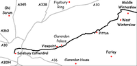 | 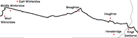 | 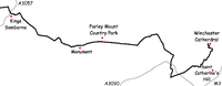 |