
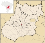
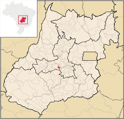
Avelinópolis
Encyclopedia
| Avelinópolis | |
|---|---|
| State | Goiás Goiás Goiás is a state of Brazil, located in the central part of the country. The name Goiás comes from the name of an indigenous community... |
| Area: | 164.6 km² |
| Population: | 2,375 (IBGE 2007 estimate) |
| Elevation: | 729 m above sea level |
| Postcode (CEP): | 75395-000 |
| IBGE statistical microregion: | Anicuns Microregion Anicuns Microregion The Anicuns Microregion is a geographical division in the state of Goiás, Brazil. It is made up of 13 municipalities located near Anicuns, a small city and municipality west of Goiânia... |
| Became a city: | 1963 |
| Distance to Goiânia Goiânia -Climate:The city has a tropical wet and dry climate with an average temperature of . There's a wet season, from October to April, and a dry one, from May to September. Annual rainfall is around 1,520 mm.... : |
74 km |
| Website: | none |
| Geographical coordinates: | 16°27′S 49°45′W |
Municipality
A municipality is essentially an urban administrative division having corporate status and usually powers of self-government. It can also be used to mean the governing body of a municipality. A municipality is a general-purpose administrative subdivision, as opposed to a special-purpose district...
in eastern Goiás
Goiás
Goiás is a state of Brazil, located in the central part of the country. The name Goiás comes from the name of an indigenous community...
state, Brazil
Brazil
Brazil , officially the Federative Republic of Brazil , is the largest country in South America. It is the world's fifth largest country, both by geographical area and by population with over 192 million people...
.
Communications and Location
The distance to the regional center of (AnicunsAnicuns
Anicuns is a small city and municipality in central Goiás state, Brazil.-Geographical Facts:Anicuns is located in the Anicuns Microregion, which includes 13 cities with a population of 103276 inhabitants in a total area of 5483.10 km²....
)is 26 km. Highway connections from the state capital are made by state highway BR-069 west from Goiânia
Goiânia
-Climate:The city has a tropical wet and dry climate with an average temperature of . There's a wet season, from October to April, and a dry one, from May to September. Annual rainfall is around 1,520 mm....
, through Trindade
Trindade
-Transportation:Trindade are linked with São Tomé and Príncipe's only highways linking to the capital city of São Tomé, another linking Neves and Santana and another linking to Guadalupe as well....
, Santa Bárbara de Goiás
Santa Bárbara de Goiás
Santa Bárbara de Goiás is a small town and municipality in eastern Goiás state, Brazil.-Location:Santa Bárbara is located due west of Goiânia. Nearby towns are Trindade , and Nazário is 25 km...
, and then 25 kilometers northwest to Avelinópolis. Neighboring municipalities are Santa Bárbara de Goiás
Santa Bárbara de Goiás
Santa Bárbara de Goiás is a small town and municipality in eastern Goiás state, Brazil.-Location:Santa Bárbara is located due west of Goiânia. Nearby towns are Trindade , and Nazário is 25 km...
, Anicuns
Anicuns
Anicuns is a small city and municipality in central Goiás state, Brazil.-Geographical Facts:Anicuns is located in the Anicuns Microregion, which includes 13 cities with a population of 103276 inhabitants in a total area of 5483.10 km²....
, Nazário
Nazário
Nazário is a small town and municipality in eastern Goiás state, Brazil.-Location:Nazário is located 74 km. west of the state capital, Goiânia a few kilometers west of the Rio dos Bois, a major tributary of the Paranaíba River. The regional center, Anicuns, is 21 km to the northwest...
, Araçu
Araçu
Araçu is a small town and municipality in central Goiás state, Brazil.-Location:Araçu is part of the Anápolis Microregion and is a short distance northwest of the state capital, Goiânia. It has boundaries with Itaberaí, Itauçu, and Caturaí...
, and Americano do Brasil
Americano do Brasil
Americano do Brasil is a small town and municipality in eastern Goiás state, Brazil.-Location:Americano do Brasil is located in the Anicuns Microregion, which is northwest of the state capital, Goiânia. It is 37 kilometers southwest of Itaberaí and 113 kilometers northwest of Goiânia. Highway...
.
Demographic and Political Data
- Population density: 14.48 inhab/km² (2007)
- Population growth rate 2000/2007: -0,77.%
- Urban population in 2007: 1,804
- Rural population in 2007: 571 (In 1980 the rural population was greater than the urban: 1,449 rural and 1,238 urban.)
- Eligible voters: 2,717(12/2007)
- City government in 2005: mayor (Waltenir Peixoto de Miranda), vice-mayor (Leonardo Protásio Evangelista da Rocha), and 09 councilmembers
Economy
The main economic activities were cattle raising, agriculture, commerce, and small transformation industries. There was a substantial informal economy. The largest employer was public administration. There were 29,000 head of cattle (8,000 dairy cows) in 2006. The poultry industry was important with over 170,000 chicks registered in 2006. The main agricultural products in 2006 were bananas, coffee, oranges, rice, sugarcane, beans, manioc, corn, and tomatoes.In 2007 there were 260 automobiles and pickup trucks, giving a ratio of 9 inhabitants for each motor vehicle.
Health and education
- Infant mortality in 2000: 23.49
- Infant mortality in 1990: 43.64
- Hospitals: 01 with 16 beds (2006)
- Literacy rate in 2000: 82.8
- Schools and Student Enrollment: 2, 709 (2006)
- Higher education: none reported for 2007
- MHDI: 0.736
- State ranking: 121 (out of 242 municipalities)
- National ranking: 2,261 (out of 5,507 municipalities)
For the complete list see frigoletto.com.br