

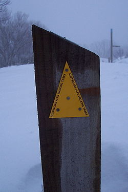
Australian Alps Walking Track
Encyclopedia
Victoria (Australia)
Victoria is the second most populous state in Australia. Geographically the smallest mainland state, Victoria is bordered by New South Wales, South Australia, and Tasmania on Boundary Islet to the north, west and south respectively....
, New South Wales
New South Wales
New South Wales is a state of :Australia, located in the east of the country. It is bordered by Queensland, Victoria and South Australia to the north, south and west respectively. To the east, the state is bordered by the Tasman Sea, which forms part of the Pacific Ocean. New South Wales...
and ACT
Australian Capital Territory
The Australian Capital Territory, often abbreviated ACT, is the capital territory of the Commonwealth of Australia and is the smallest self-governing internal territory...
. It is 655km long, starting at Walhalla, Victoria
Walhalla, Victoria
Walhalla is a small town in Victoria, Australia, founded as a gold-mining community in early 1863 and at its peak home to around 2,500 residents. Today, the town has a population of fewer than 20 permanent residents, though it has a large proportion of houses owned as holiday properties. It...
and running through to Tharwa, ACT
Tharwa, Australian Capital Territory
Tharwa is a small village within the Australian Capital Territory, south of Canberra, the capital city of Australia. At the 2006 census, Tharwa had a population of 109....
near Canberra
Canberra
Canberra is the capital city of Australia. With a population of over 345,000, it is Australia's largest inland city and the eighth-largest city overall. The city is located at the northern end of the Australian Capital Territory , south-west of Sydney, and north-east of Melbourne...
. The track weaves mainly though Australian national parks, such as Alpine National Park
Alpine National Park
The Alpine National Park is a national park in Victoria , northeast of Melbourne. It covers much of the higher areas of the Great Dividing Range in Victoria, including Victoria's highest point, Mount Bogong and the associated subalpine woodland and grassland of the Bogong High Plains...
and Kosciuszko National Park
Kosciuszko National Park
Kosciuszko National Park covers 690,000 hectares and contains mainland Australia's highest peak, Mount Kosciuszko for which it is named, and Cabramurra the highest town in Australia...
, though it is not exclusively restricted to national parks. It ascends many peaks including Mount Kosciuszko
Mount Kosciuszko
Mount Kosciuszko is a mountain located in the Snowy Mountains in Kosciuszko National Park. With a height of 2,228 metres above sea level, it is the highest mountain in Australia...
, Mount Bogong
Mount Bogong
Mount Bogong , located in the Alpine National Park, is the highest mountain in Victoria, Australia. The Big River separates the massif of the mountain from the Bogong High Plains to the south. "Bogong" in the local Aboriginal language means bigfella...
, and Bimberi Peak
Bimberi Peak
Bimberi Peak or Mount Bimberi is the highest mountain in the Australian Capital Territory at 1912 metres. It is located on the border between New South Wales and the ACT, the NSW portion in Kosciuszko National Park and the ACT portion in Namadgi National Park...
, the highest points in N.S.W., Victoria, and the A.C.T. respectively. The AAWT crosses exposed high plains including the Victorian Bogong High Plains and the Main Range in NSW. To walk the whole trail can take between 5 to 8 weeks.
It has been signposted for part of its length in a tri-state agreement. However, most parts of the Track require hikers to have highly developed navigation skills.
The Australian Alps Walking Track is an extension of the older Victorian Alpine Walking Track, established during the 1970s. The Victorian track was extended after many years of promotion by the Federation of Victorian Walking Clubs and various government departments. The NSW stretch of the walk is less imaginative then the Victorian section. Where the Victorian section typically follows spurs and ridges, the NSW section typically follows fire trails/tracks. The route recommended by John Siseman adds some interest to the NSW section of the walk.
Between Walhalla and Tharwa it passes through these National Parks:
- Baw Baw National ParkBaw Baw National ParkBaw Baw is a national park in Victoria, Australia, 111 km east of Melbourne. It contains the Baw-Baw Plateau and Mount Baw Baw, a small ski resort, including nearby town, technically outside the national park....
- Alpine National ParkAlpine National ParkThe Alpine National Park is a national park in Victoria , northeast of Melbourne. It covers much of the higher areas of the Great Dividing Range in Victoria, including Victoria's highest point, Mount Bogong and the associated subalpine woodland and grassland of the Bogong High Plains...
- Kosciuszko National ParkKosciuszko National ParkKosciuszko National Park covers 690,000 hectares and contains mainland Australia's highest peak, Mount Kosciuszko for which it is named, and Cabramurra the highest town in Australia...
- Namadgi National ParkNamadgi National ParkNamadgi National Park is located in the southwestern part of the Australian Capital Territory, bordering Kosciuszko National Park in New South Wales. It lies approximately 40 km southwest of Canberra, and makes up approximately 46% of the ACT's land area....
- Brindabella National ParkBrindabella National ParkBrindabella National Park is a national park in New South Wales, Australia, 267 km southwest of Sydney in the Brindabella Ranges.On 7 November 2008 The Park was added to the Australian National Heritage List as one of eleven areas constituting the Australian Alps National Parks and...