
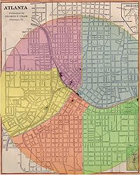
Atlanta ward system
Encyclopedia
From its incorporation in 1848, the municipal boundaries Atlanta, Georgia
were extended repeatedly from a small area around its railroad station to today's city covering 131.7 mi2.
Prior to 1954, Atlanta was divided into political divisions called wards. The number of wards grew as the city grew.
 The 1848 charter only specified election of six city-wide councilmembers, but on January 9, 1854, an ordinance was adopted that divided the town into five wards and two councilmen from each ward would be elected to coincide with the completion of the first official city hall.
The next election with the new rules on January 15, 1855, decided those first Ward bosses who would serve with the short-term mayor, Allison Nelson
.
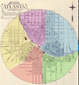
The boundaries were as follows:
 During a huge boom of post-war building, two new wards were added from parts of the First, Fourth and Fifth to reflect the changing look of the city. This would be the layout until the city limits were expanded in 1874.
 A new city charter was approved by Governor Smith
on February 28, 1874, which increased the radius of the city from one to one and a half miles, reduced the number of wards back to five and created a bi-cameral council of two councilmen from each ward and a second body of three at-large aldermen was established.
Each year one of the aldermen would be up for election and during his last year in office would serve as president of the other body.
They acted separately on finances but together for all other business.
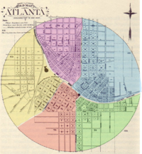
The new ward layout was as follows:
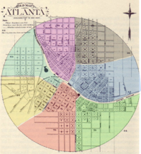
 On Nevember 5, 1883 a Sixth Ward (beige) was carved out of the Fourth and Fifth Wards.
Its boundaries started at Butler and the GRR (today's Grady Hospital) north to North Ave
at Myrtle St, then up Myrtle to the city limit at 3rd St.
Follow the arc of the city limit to Williams, south to Cain (International) then James (Church) to Forsyth south to the tracks then east on the tracks to origin.
This separated the wealthy Peachtree corridor from the other parts of north Atlanta. (Garrett Vol II, p. 53–54)
was annexed into the city in 1894, it became a new Seventh Ward.
In October 1897 Frank P. Rice
drove a failed proposal to annex Pittsburgh
, Reynoldstown
, Bellwood and and what was then called "north Atlanta".
"North Atlanta" was defined at the time roughly as today's Midtown
, Georgia Tech, and English Avenue:
In 1902 a special committee made a new proposal to annex those areas as well as "Bonnie Brae", Copenhill
and the "St. Charles Avenue" area (in today's Virginia Highland). By then, "north Atlanta" was being referred to as "Peachtree".
In 1905, the Eighth Ward was added. An act of the Georgia General Assembly
was enacted on August 3, 1904 which designated the area from then current city limits (at 6th St and West Peachtree), north to 15th St, then east to Piedmont Ave, then northeast to Southern Railway
(basically follow Piedmont to the Ansley Park
area). Then southwardly along the railway the limits. The act also took part of the Sixth Ward north of North Ave. into the new Eighth Ward.
, part of Druid Hills
, Edgewood
, Reynoldstown
, East Atlanta
and Brownwood. Edgewood alone had had its own city government before the annexation.
were annexed into Atlanta on Jan. 1, 1952. This was by far the largest expansion in Atlanta's history, tripling the size of the city to 118 mi2 and adding 100,000 residents. This helped spread the burden of providing public services by adding to the base a large group of mostly more affluent residents. The annexation was viewed as a triumph of Mayor Hartsfield.
Atlanta would in the 1970s again try, but without success, to repeat the process by state legislation to annex what is now Sandy Springs
to Atlanta.
).
Sandtown's 2007 petition for annexation was put on hold.
Atlanta, Georgia
Atlanta is the capital and most populous city in the U.S. state of Georgia. According to the 2010 census, Atlanta's population is 420,003. Atlanta is the cultural and economic center of the Atlanta metropolitan area, which is home to 5,268,860 people and is the ninth largest metropolitan area in...
were extended repeatedly from a small area around its railroad station to today's city covering 131.7 mi2.
Prior to 1954, Atlanta was divided into political divisions called wards. The number of wards grew as the city grew.
1854
The next election with the new rules on January 15, 1855, decided those first Ward bosses who would serve with the short-term mayor, Allison Nelson
Allison Nelson
Allison Nelson was the ninth mayor of Atlanta, Georgia, as well as a brigadier general in the Confederate army during the American Civil War....
.
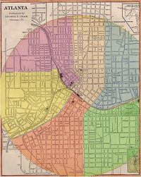
The boundaries were as follows:
- First (yellow): all land west of the W&A Railroad and Whitehall Street. This diverse ward had concentrations of industry and working class people (such as railroad men) in the northern and western parts but the eastern section was home to some of Atlanta's wealthiest citizens, such as Richard PetersRichard Peters (Atlanta)Richard Peters was an American railroad man and a founder of Atlanta.Grandson of Judge Richard Peters, Jr...
. - Second (red): land south of Georgia RR between Whitehall and McDonough. This wealthy section included the bulk of the town's wholesalers, warehouses, grocers and hotels. The residential areas included people like Dr. Joseph ThompsonJoseph Thompson (doctor)Dr. Joseph Thompson was an early settler of Atlanta, Georgia, hotelier, and real-estate investor.Born to a Pennsylvania-bred family in Spartanburg County, South Carolina, he practiced medicine as a youth...
. - Third (green): land south of Georgia RR and east of McDonough. This ward included the new city hall, a number of mills along the railroad and the east many large estates including that of Lemuel P. GrantLemuel P. GrantLemuel Pratt Grant was an American engineer and businessman.He was Atlanta's quintessential railroad man as well as a major landowner and civic leader....
. - Fourth (blue): north of Georgia RR and east of Ivy. This ward had two of the roughest sections of town; the red-light district along Decatur Street (including Murrell's RowMurrell's RowMurrell's Row was a red-light district of Atlanta "starting at the juncture of Line, Decatur and Peachtree streets" Murrell's Row was a red-light district of Atlanta "starting at the juncture of Line, Decatur and Peachtree streets" Murrell's Row was a red-light district of Atlanta "starting at the...
) and Slabtown but the northern part was home to mostly small farms. - Fifth (violet): west of Ivy and north of A&W Railroad. This ward contained the large homes along Peachtree StreetPeachtree StreetPeachtree Street is the main street of Atlanta. The city grew up around the street, and many of its historical and municipal buildings are or were located along it...
and the southern part, Fairlie-PoplarFairlie-PoplarThe Fairlie-Poplar Historic District is part of the central business district in downtown Atlanta. It is named for the two streets that cross at its center, northeast-only Fairlie and southeast-only Poplar. Fairlie-Poplar is immediately north of Five Points, the definitive centerpoint and...
was also largely residential with warehousing along the western part.
1871
- Sixth Ward (aqua): established October 1871 as the half of the First Ward north of Hunter St (MLK). This division left the wealthy in the First ward and gave the working-class people to the north two councilmen of their own.
- Seventh Ward (grey): established December 2, 1871 of parts of the Fourth and Fifth. Specifically from the "junction of Houston and Pryor streets, thence through lot nineteen, between blocks three, one and two, five and six, to the city limits; thence northerly along the city limits to Peachtree Street; thence south along Peachtree Street and Pryor Street to the beginning." And the Fourth was extended "from Ivy Street west to Pryor, and from Houston Street south to the railroad, and that Pryor Street shall be the line between the fourth and fifth wards, and Pryor and Peachtree streets between the fifth and seventh wards." This gave the red-light district to the Fourth and created a new Ward of mostly farmers and to the west, fine residences along Ivy and the east side of Peachtree.
1874
James Milton Smith
James Milton Smith was a Confederate infantry colonel in the American Civil War, as well as a post-war Governor of Georgia. He was noted as an ardent opponent of Radical Reconstruction.-Biography:...
on February 28, 1874, which increased the radius of the city from one to one and a half miles, reduced the number of wards back to five and created a bi-cameral council of two councilmen from each ward and a second body of three at-large aldermen was established.
Each year one of the aldermen would be up for election and during his last year in office would serve as president of the other body.
They acted separately on finances but together for all other business.
The new ward layout was as follows:
- First Ward (yellow) was bounded by Western & Atlantic Railroad, Foundry St, south around the city limits to modern Peachtree StreetPeachtree StreetPeachtree Street is the main street of Atlanta. The city grew up around the street, and many of its historical and municipal buildings are or were located along it...
- Second Ward (red) was bounded by the Georgia Railroad, Whitehall south to city limits then north-east to McDonough (Capital Ave) and up to the railroad
- Third WardThird Ward (Atlanta)Atlanta's Third Ward was defined in 1880 as the area bounded on the North by Georgia Railroad, West by Butler & McDonough Streets, South and East by the city limits...
(green) was bounded by Butler (Jesse Hill Dr) and McDonough Streets south to the city limits north-east to Georgia RR, then west to Butler - Fourth WardFourth Ward (Atlanta)-1874:A new city charter increased the radius of the city from one to one and a half miles, reduced the number of wards back to five and created a bi-cameral council of two councilmen from each ward and a second body of three at-large aldermen was established....
(blue) from Pryor and tracks east on Georgia RR to city limits then north west to West Peachtree and south to origin. - Fifth WardFifth Ward (Atlanta)Atlanta's Fifth Ward encompassed mainly what is now the part of downtown and midtown between the west side of Peachtree and the Western and Atlantic Railroad.-1854:...
(purple) from Pryor and tracks north-east to Peachtree, then West Peachtree to city limits, south-west to Foundry and W&A RR and east to origin
1883
Its boundaries started at Butler and the GRR (today's Grady Hospital) north to North Ave
North Avenue (Atlanta)
North Avenue in Atlanta is a major avenue in Atlanta that divides Downtown Atlanta from Midtown Atlanta. North Avenue stretches continuously in Atlanta from Candler Park in the east, across Interstate 75 & Interstate 85, along the southern boundary of the Georgia Institute of Technology, to Joseph E...
at Myrtle St, then up Myrtle to the city limit at 3rd St.
Follow the arc of the city limit to Williams, south to Cain (International) then James (Church) to Forsyth south to the tracks then east on the tracks to origin.
This separated the wealthy Peachtree corridor from the other parts of north Atlanta. (Garrett Vol II, p. 53–54)
1894
When West EndWest End (Atlanta)
The West End neighborhood of Atlanta is on the National Register of Historic Places and can be found southwest of Castleberry Hill, east of Westview, west of Adair Park Historic District, and just north of Oakland City...
was annexed into the city in 1894, it became a new Seventh Ward.
1905
Further expansion of the city limits was part of a long effort.In October 1897 Frank P. Rice
Frank P. Rice
Franklin "Frank" P. Rice was an investor, businessman and local politician in Atlanta, Georgia....
drove a failed proposal to annex Pittsburgh
Pittsburgh (Atlanta)
Pittsburgh is a neighborhood of Atlanta, Georgia, founded in 1883 as a black working-class suburb alongside the Pegram rail shops. It was named Pittsburgh because the industrial area reminded one of Pittsburgh, Pennsylvania and its famous steel mills...
, Reynoldstown
Reynoldstown
Reynoldstown is a historic neighborhood on the east side of Atlanta, Georgia, located between the Cabbagetown and Edgewood neighborhoods, north of Memorial Drive...
, Bellwood and and what was then called "north Atlanta".
"North Atlanta" was defined at the time roughly as today's Midtown
Midtown Atlanta
Midtown is the second largest financial district in the city of Atlanta, Georgia, situated between the commercial and financial districts of Downtown and SoNo to the south and the affluent residential and commercial district of Buckhead to the north...
, Georgia Tech, and English Avenue:
- today's Midtown between Myrtle St. in the Midtown Historic DistrictMidtown Historic District (Atlanta, Georgia)The Midtown Historic District in Midtown Atlanta, Georgia is a historic district that was listed on the National Register of Historic Places in 1999....
and Cherry St., now inside the Georgia Tech campus, as far north as 14th St (then called Wilson Ave.) - most of what is now the Georgia Tech campus, south of what was then 5th Street
- the area west of Georgia Tech, south of Jefferson St., as far west as Ashby St. (now Lowery Blvd.), including today's English Avenue neighborhood
In 1902 a special committee made a new proposal to annex those areas as well as "Bonnie Brae", Copenhill
Copenhill
Copenhill, Copenhill Park, or Copen Hill was a neighborhood of Atlanta, Georgia which was located largely where the Carter Center now sits, and which now forms part of the Poncey-Highland neighborhood. It lay:...
and the "St. Charles Avenue" area (in today's Virginia Highland). By then, "north Atlanta" was being referred to as "Peachtree".
In 1905, the Eighth Ward was added. An act of the Georgia General Assembly
Georgia General Assembly
The Georgia General Assembly is the state legislature of the U.S. state of Georgia. It is bicameral, being composed of the Georgia House of Representatives and the Georgia Senate....
was enacted on August 3, 1904 which designated the area from then current city limits (at 6th St and West Peachtree), north to 15th St, then east to Piedmont Ave, then northeast to Southern Railway
Southern Railway (US)
The Southern Railway is a former United States railroad. It was the product of nearly 150 predecessor lines that were combined, reorganized and recombined beginning in the 1830s, formally becoming the Southern Railway in 1894...
(basically follow Piedmont to the Ansley Park
Ansley Park
Ansley Park is an affluent residential neighborhood in Atlanta, Georgia, located just east of Midtown and west of Piedmont Park. One of the first suburban neighborhoods in the city designed for automobiles, it features wide, winding roads rather than the grid pattern typical of older streetcar...
area). Then southwardly along the railway the limits. The act also took part of the Sixth Ward north of North Ave. into the new Eighth Ward.
1909
On January 1, 1909, a Ninth Ward was formed out of just annexed CopenhillCopenhill
Copenhill, Copenhill Park, or Copen Hill was a neighborhood of Atlanta, Georgia which was located largely where the Carter Center now sits, and which now forms part of the Poncey-Highland neighborhood. It lay:...
, part of Druid Hills
Druid Hills, Georgia
Druid Hills is a community which includes both a census-designated place in unincorporated DeKalb County, Georgia, United States, as well as a neighborhood of the city of Atlanta. The CDP's population was 14,568 at the 2010 census...
, Edgewood
Edgewood (Atlanta)
Edgewood is a neighborhood located on the east side of Atlanta, Georgia, United States, located approximately three miles east of downtown Atlanta.-History:...
, Reynoldstown
Reynoldstown
Reynoldstown is a historic neighborhood on the east side of Atlanta, Georgia, located between the Cabbagetown and Edgewood neighborhoods, north of Memorial Drive...
, East Atlanta
East Atlanta
East Atlanta is a neighborhood of Atlanta, Georgia in the eastern portion of the city. The term "East Atlanta" is frequently misused to refer to the entire eastern portion of the city located in DeKalb County, roughly 10% of Atlanta's area annexed in 1909...
and Brownwood. Edgewood alone had had its own city government before the annexation.
1929
A Thirteenth Ward was created as the section of the Ninth Ward north of St. Charles and east of the Belt Line to the west side of Briarcliff and north the corporate limits.1937
On March 14, 1935, the legislature reduced the number of wards from 13 to 6 and the thirty-nine member city council is cut to eighteen members effective January 1, 1937. The wards were combined as such:- First: old 2nd & 3rd (south from Central RR to Grant Park)
- Second: old 11th & 12th (southeast: Ormewood, East Atlanta and East Lake)
- Third: old 1st, 5th & 6th (northwest from Central RR around to three blocks east of Peachtree)
- Fourth: old 7th & 10th (from West End to Oakland City)
- Fifth: old 4th & 8th (from Georgia RR up to Piedmont Park and Ansley west of the Belt Line)
- Sixth: old 9th & 13th (everything east of the Belt Line and north of Georgia RR: Inman Park, Druid Hills, etc)
1952
In 1951, after a failed 1947 referendum and two other failed attempts, the state legislature passed a "Plan of Improvement" by which Buckhead and Cascade HeightsCascade Heights
Cascade Heights is an affluent predominantly African-American neighborhood in southwest Atlanta. Along with Sandtown and other portions of unincorporated South Fulton County, the area has a reputation as having a high concentration of the African-American elite in the city.Cascade Heights, or...
were annexed into Atlanta on Jan. 1, 1952. This was by far the largest expansion in Atlanta's history, tripling the size of the city to 118 mi2 and adding 100,000 residents. This helped spread the burden of providing public services by adding to the base a large group of mostly more affluent residents. The annexation was viewed as a triumph of Mayor Hartsfield.
Atlanta would in the 1970s again try, but without success, to repeat the process by state legislation to annex what is now Sandy Springs
Sandy Springs, Georgia
Sandy Springs is a city in north Georgia, United States. It is a northern suburb of Atlanta. With a 2010 population of 93,853, Sandy Springs is the sixth-largest city in the state and the second-largest city in Metro Atlanta. Sandy Springs is located in north Fulton County, Georgia, just south of...
to Atlanta.
1954
Ward system is ended. No longer a bicameral body, only a board of six aldermen with a Vice-Mayor serving as president of the board. All positions were elected city-wide. (For post-ward setup, see Political structure of AtlantaPolitical structure of Atlanta
The current political structure in Atlanta includes a mayor and body of one councilman from each of 12 districts, a City Council President, and 3 other at-large councilmen:*Post 1 representing districts 1-4*Post 2 representing districts 5-8...
).
2006
Multiple small areas adjacent to southwestern Atlanta were annexed including Midwest Cascade, Cascade Glen and the Horseshoe Community.Sandtown's 2007 petition for annexation was put on hold.