
Aruanã
Encyclopedia
| Aruanã | |
|---|---|
| State | Goiás Goiás Goiás is a state of Brazil, located in the central part of the country. The name Goiás comes from the name of an indigenous community... |
| Area: | 3,050.3 km² |
| Population: | 6,476 (IBGE 2007) |
| Elevation: | 250 m above sea level |
| Postcode (CEP): | 76710-000 |
| Became a municipality: | 1958 |
| Distance to Goiânia Goiânia -Climate:The city has a tropical wet and dry climate with an average temperature of . There's a wet season, from October to April, and a dry one, from May to September. Annual rainfall is around 1,520 mm.... : |
324 km |
| IBGE statistical microregion: | Rio Vermelho Microregion Rio Vermelho Microregion The Rio Vermelho Microregion is a geographical region in central Goiás state, Brazil. The most important city is Goiás, also known as Goiás Velho. The Rio Vermelho, a tributary of the Araguaia River flows through the region... |
| Website: | n/a |
| Coordinates: | 14°55′51"S 51°01′48"W |
Municipality
A municipality is essentially an urban administrative division having corporate status and usually powers of self-government. It can also be used to mean the governing body of a municipality. A municipality is a general-purpose administrative subdivision, as opposed to a special-purpose district...
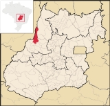
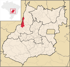
in north-western Goiás
Goiás
Goiás is a state of Brazil, located in the central part of the country. The name Goiás comes from the name of an indigenous community...
state, Brazil
Brazil
Brazil , officially the Federative Republic of Brazil , is the largest country in South America. It is the world's fifth largest country, both by geographical area and by population with over 192 million people...
. It has a total area of 3,050.3 km², with a population of 6,476 in 2007. Aruanã is a tourist spot on the Araguaia River
Araguaia River
The Araguaia River or, in Portuguese, Rio Araguaia is one of the major rivers of Brazil, and the principal tributary of the Tocantins. It has a total length of approximately 2,627 km. Araguaia means "river of macaws" in the Tupi language....
and is a major producer of cattle.
Location
Aruanã is located 324 km from the state capital, GoiâniaGoiânia
-Climate:The city has a tropical wet and dry climate with an average temperature of . There's a wet season, from October to April, and a dry one, from May to September. Annual rainfall is around 1,520 mm....
, 59 km northwest of Araguapaz
Araguapaz
Araguapaz is a small town and municipality in north-western Goiás state, Brazil. The population was 7,482 in a total area of 2,193.6 km². It is a major producer of cattle.-Location and Municipal Boundaries:...
. It is part of the Rio Vermelho Microregion
Rio Vermelho Microregion
The Rio Vermelho Microregion is a geographical region in central Goiás state, Brazil. The most important city is Goiás, also known as Goiás Velho. The Rio Vermelho, a tributary of the Araguaia River flows through the region...
. Highway connections with Goiânia
Goiânia
-Climate:The city has a tropical wet and dry climate with an average temperature of . There's a wet season, from October to April, and a dry one, from May to September. Annual rainfall is around 1,520 mm....
are made by GO-070 / Goianira
Goianira
Goianira is a small city and municipality in central Goiás state, Brazil, located 32 kilometers northwest of the state capital, Goiânia. The population was 24,110 in a total area of 200.4 km² . Goianira is becoming a major producer of shoes.Goianira is four kilometers east of highway BR-457 /...
/ Itaberaí
Itaberaí
Itaberaí is a small city and municipality in central Goiás state, Brazil. Itaberaí is a large producer of agricultural products including corn, rice, soybeans, tomatoes, and sugarcane.-Location:...
/ Goiás
Goiás, Goiás
Goiás is a small city and municipality in the state of Goiás in Brazil. The population was 24,072 in a total area of 3,108 km² . It is the former capital of the state and preserves much of its colonial heritage...
/ GO-164 / Faina / Araguapaz
Araguapaz
Araguapaz is a small town and municipality in north-western Goiás state, Brazil. The population was 7,482 in a total area of 2,193.6 km². It is a major producer of cattle.-Location and Municipal Boundaries:...
/ GO-530 / BR-2. See Sepin for a list of all distances.
Municipal Boundaries
Municipal boundaries:- North: the state of Mato GrossoMato GrossoMato Grosso is one of the states of Brazil, the third largest in area, located in the western part of the country.Neighboring states are Rondônia, Amazonas, Pará, Tocantins, Goiás and Mato Grosso do Sul. It also borders Bolivia to the southwest...
and Nova CrixásNova CrixásNova Crixás is a small town and municipality in northeastern Goiás state, Brazil. It is one of the largest municipalities in the state and is the largest producer of beef cattle in the state.... - South: MatrinchãMatrinchãMatrinchã is a small town and municipality in west-central Goiás state, Brazil.-Location:*Statistical microregion: Rio Vermelho Microregion*Distance to the state capital: 261 km.*Distance to regional center : 106 km....
and ItapirapuãItapirapuãItapirapuã is a small town and municipality in the state of Goiás in Brazil. The population was 8,208 in 2007 in a total area of 2,043.7 km² . Itapirapuã is a large producer of cattle.-Location and Boundaries:... - East: MozarlândiaMozarlândiaMozarlândia is a small city and municipality in north-central Goiás state, Brazil.It is located in the Valley of the Araguaia River, 300 kilometers from the state capital, Goiânia, and is served by highways GO-164 and GO-334....
, AraguapazAraguapazAraguapaz is a small town and municipality in north-western Goiás state, Brazil. The population was 7,482 in a total area of 2,193.6 km². It is a major producer of cattle.-Location and Municipal Boundaries:...
and MatrinchãMatrinchãMatrinchã is a small town and municipality in west-central Goiás state, Brazil.-Location:*Statistical microregion: Rio Vermelho Microregion*Distance to the state capital: 261 km.*Distance to regional center : 106 km.... - West: BritâniaBritâniaBritânia is a small town and municipality in northwestern Goiás state, Brazil. The population was 5,073 in a total area of 1461.2 km².-Municipal Boundaries:Municipal boundaries:*North: Aruanã*South: Jussara*East: Itapirapuã and Aruanã...
and Mato GrossoMato GrossoMato Grosso is one of the states of Brazil, the third largest in area, located in the western part of the country.Neighboring states are Rondônia, Amazonas, Pará, Tocantins, Goiás and Mato Grosso do Sul. It also borders Bolivia to the southwest...
Demographic and Political Data
- Population density: 2.12 hab/km² (2007)
- Population growth rate 2000/2007: 3,49%
- Population in 1980: 7,193
- Population in 1991: 4,909
- Urban population: 5,349 (2007)
- Rural population: 1,127 (2007)
- Eligible voters: 4,543 (12/2007)
- City government in 2005: mayor (Hermano de Carvalho), vice-mayor (Antônio Claret Nogueira Martins), and 9 councilmembers
Climate and Tourism
The climate is moist tropical with an average temperature of 27°C, with two well defined seasons: dry and rainy, with regular rainfall in the period of October to March. This type of climate favors the formation of vegetation made up of savanna, broken by farmland and pastureland. There are still stands of tropical forest, especially near the rivers.The town is located on the Araguaia River
Araguaia River
The Araguaia River or, in Portuguese, Rio Araguaia is one of the major rivers of Brazil, and the principal tributary of the Tocantins. It has a total length of approximately 2,627 km. Araguaia means "river of macaws" in the Tupi language....
and attracts thousands of tourists, especially in the dry season, from May to August, when extensive sandbanks are formed providing beaches for sunbathers and swimmers. There is also extensive sport fishing in the region.
Economic Information
In addition to tourism, the economy is based on cattle raising and agriculture. The cattle herd had 205,000 head (1,800 milk cows) in 2003. There is also large hardwood extraction and small lumbermills.Main crops (2003)in planted area are corn and rice.
The main economic activities were agriculture (including lumber extraction and processing), commerce, hotels and restaurants, and public administration. There is a large informal economy. There is financial Institution: Banco Itaú S.A.
Health and education
- Health establishments: 2 (2007)
- Hospitals: 1 with 15 beds
- Infant mortality (in 1,000 live births) in 2000: 26.34
- Infant mortality in 1990: 31.02
- Schools: 6 with 1,989 students (2006)
- Higher education enrollment, teachers, and schools: Campus of the UEG (Universidade Estadual de Goiás), established in September 2004. No data on enrollment or teachers.
- Literacy rate in 2000: 83.5
- Literacy rate in 1990: 71.1
- MHDI: 0.721
- State ranking: 172 (out of 242 municipalities)
- National ranking: 2,611 (out of 5,507 municipalities)
For the complete list see Frigoletto.com.
History
The history of Aruanã began with the building of a military fort in 1849 at the point where the Rio Vermelho enters the Rio Araguaia. The region was occupied by the Carajá Indians. The fort was called Leopoldina and later Santa Leopoldina. In 1868 the first steam boats appeared on the Araguaia and the settlement was a major port. In 1939 the name was changed to Aruanã, a native fish and the dance of the local Indians, and the village became a district in the municipality of GoiásGoiás, Goiás
Goiás is a small city and municipality in the state of Goiás in Brazil. The population was 24,072 in a total area of 3,108 km² . It is the former capital of the state and preserves much of its colonial heritage...
. In 1958 it became an independent municipality.