

Argo (oceanography)
Encyclopedia
Ocean
An ocean is a major body of saline water, and a principal component of the hydrosphere. Approximately 71% of the Earth's surface is covered by ocean, a continuous body of water that is customarily divided into several principal oceans and smaller seas.More than half of this area is over 3,000...
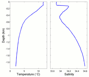
ic robotic probes deployed worldwide. The probes float as deep as 2 km. Once every 10 days, the probes surface, measuring conductivity and temperature profiles to the surface. From these, salinity
Salinity
Salinity is the saltiness or dissolved salt content of a body of water. It is a general term used to describe the levels of different salts such as sodium chloride, magnesium and calcium sulfates, and bicarbonates...
and density can be calculated. The data are transmitted to scientists on shore via satellite
Satellite
In the context of spaceflight, a satellite is an object which has been placed into orbit by human endeavour. Such objects are sometimes called artificial satellites to distinguish them from natural satellites such as the Moon....
. The data collected are freely available to everyone, without restrictions. The initial project goal was to deploy 3,000 probes, completed in November 2007.
International collaboration
The Argo program is a collaboration between 50 research and operational agencies from 31 countries (shown on the graphic above), with the United StatesUnited States
The United States of America is a federal constitutional republic comprising fifty states and a federal district...
contributing over half the total funding (as of December 2004). Argo is a component of the Integrated Ocean Observing System
Integrated Ocean Observing System
The Integrated Ocean Observing System is an organization of systems that routinely and continuously provides quality controlled data and information on current and future states of the oceans and Great Lakes from the global scale of ocean basins to local scales of coastal ecosystems...
.
Float operation
The Argo program was designed to operate on the same 10-day duty cycle to match the existing satellite measurements of the ocean's sea surface. These satellites, called Topex/PoseidonTOPEX/Poseidon
Launched in 1992, TOPEX/Poseidon was a joint satellite mission between NASA, the U.S. space agency, and CNES, the French space agency, to map ocean surface topography. The first major oceanographic research vessel to sail into space, TOPEX/Poseidon helped revolutionize oceanography by proving the...
and Jason 1
Jason 1
Jason-1 is a satellite oceanography mission to monitor global ocean circulation, study the ties between the ocean and the atmosphere, improve global climate forecasts and predictions, and monitor events such as El Niño and ocean eddies....
, measure changes in the surface topography of the ocean. With such measurements, information about temperature, mass redistribution, or surface currents can be inferred. The Argo floats measure subsurface changes in temperature and salinity, hence the float measurements are complementary to the altimetry.
Argo is named after the Greek
Greece
Greece , officially the Hellenic Republic , and historically Hellas or the Republic of Greece in English, is a country in southeastern Europe....
mythical ship Argo
Argo
In Greek mythology, the Argo was the ship on which Jason and the Argonauts sailed from Iolcos to retrieve the Golden Fleece. It was named after its builder, Argus.-Legend:...
which Jason
Jason
Jason was a late ancient Greek mythological hero from the late 10th Century BC, famous as the leader of the Argonauts and their quest for the Golden Fleece. He was the son of Aeson, the rightful king of Iolcus...
and the Argonauts
Argonauts
The Argonauts ) were a band of heroes in Greek mythology who, in the years before the Trojan War, accompanied Jason to Colchis in his quest to find the Golden Fleece. Their name comes from their ship, the Argo, which was named after its builder, Argus. "Argonauts", therefore, literally means...
use on their quest for the Golden Fleece
Golden Fleece
In Greek mythology, the Golden Fleece is the fleece of the gold-haired winged ram, which can be procured in Colchis. It figures in the tale of Jason and his band of Argonauts, who set out on a quest by order of King Pelias for the fleece in order to place Jason rightfully on the throne of Iolcus...
. The name was chosen to emphasize the complementary relationship of the project with the Jason-1 satellite altimeter.
Although drifting floats had been deployed during the World Ocean Circulation Experiment
World Ocean Circulation Experiment
The World Ocean Circulation Experiment was a component of the international World Climate Research Program, and aimed to establish the role of the World Ocean in the Earth's climate system...
in the 1990s, Argo floats began to be deployed in earnest in the early 2000s. The target number of 3,000 deployed floats was reached during 2006–2007. The number of floats is continually changing as floats are lost or expire, while others are deployed. Nominally, some 750 floats are deployed each year to sustain the system. The floats have a nominal 300-km spacing, although the exact separations depend on the randomness of the float drift.
The Argo temperature and salinity measurements are yielding valuable information about the large-scale water properties and currents of the ocean, including the variability of these properties over time scales from seasonal to decadal.
Profiling
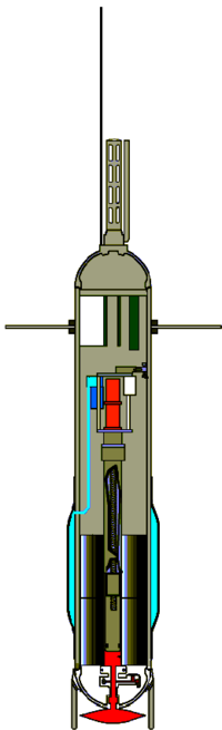
Argo floats drift at a fixed pressure (usually around 1,000 metres depth) for 10 days. After this period, within the relatively short time of around two hours, the floats move to a profiling pressure (usually 2,000 metres deep) then rise, collecting instantaneous profiles of pressure, temperature, and salinity data on their way to the surface. Once at the surface, the floats remain there for under a day, transmitting the data collected via a satellite link back to a ground station and allowing the satellite to determine their surface drift. The floats then sink again and repeat their mission.Data communication
Most of the floats use the Argos SystemArgos System
Argos is a satellite-based system which collects, processes and disseminates environmental data from fixed and mobile platforms worldwide. What makes Argos unique is the ability to geographically locate the source of the data anywhere on the Earth utilizing the Doppler effect...
of satellites to recover data, though a few are using the newer Iridium satellite constellation
Iridium satellite constellation
The Iridium satellite constellation is a large group of satellites providing voice and data coverage to satellite phones, pagers and integrated transceivers over Earth's entire surface. Iridium Communications Inc...
. The Iridium system offers significant advantages associated with the much faster data transfer. Since an Iridium float spends only 3 minutes at the sea surface, the opportunity to observe surface currents by tracking the movements of the floats is lost but the trajectories of the floats become more representative of the flow at their parking depth.
Float design
An increasing number of the floats also carry other sensors, such as for measuring dissolved oxygen.
The antenna for satellite communications is mounted at the top of the float. Once the float reaches the surface, the float is essentially a spar buoy
Buoy
A buoy is a floating device that can have many different purposes. It can be anchored or allowed to drift. The word, of Old French or Middle Dutch origin, is now most commonly in UK English, although some orthoepists have traditionally prescribed the pronunciation...
, allowing the antenna to poke above the sea surface for communication. The ocean is saline, hence an electric conductor, so that radio communications from under the sea surface are difficult.
The nominal life span of an Argo float is five years. After the internal batteries expire, the floats are allowed to sink to the ocean floor or wash ashore, though having a float wash ashore is very rare and unusual.
Data access
Argo is unique among research programs in that the real-time data are freely offered to anyone. The data collected by the network are made available with no constraint on use of the data, and most data are available for download within 24 hours of a float measurement. Data can be downloaded over the world wide webWorld Wide Web
The World Wide Web is a system of interlinked hypertext documents accessed via the Internet...
from one of two global data servers (OPeNDAP
OPeNDAP
OPeNDAP, an acronym for "Open-source Project for a Network Data Access Protocol", is a data transport architecture and protocol widely used by earth scientists. The protocol is based on HTTP and the current specification is . OPeNDAP includes standards for encapsulating structured data, annotating...
servers).
Data format
Even though data are supplied by 31 national programs, all data are available in near real-time in a single format. Argo data are in the native import format of the Ocean Data View (ODV) suite of programs. Ocean Data ViewOcean Data View
Ocean Data View - a proprietary, freely available, software package for the analysis and visualization of oceanographic and meteorological datasets....
(ODV) is proprietary but freely available software created by Reiner Schlitzer that offers flexible ways of displaying oceanographic data. Data in other formats are also available, e.g., netCDF
NetCDF
NetCDF is a set of software libraries and self-describing, machine-independent data formats that support the creation, access, and sharing of array-oriented scientific data. The project homepage is hosted by the Unidata program at the University Corporation for Atmospheric Research...
. A careful study of the manuals before starting to use the data is essential.
Data results
It is not yet possible to use Argo data to detect global change signals, as the dataset is not yet long enough to observe global change signals.Argo data result errors
During 2006, the Argo Network was thought to have showna declining trend in ocean temperatures. In February 2007, the author of the paper (Josh Willis) discovered that there were problems with the data used for the analysis.
Many references exist to the uncorrected data results
despite Josh Willis' published correction in 2008: many articles and arguments still use and promote the uncorrected data results from 2006.
Data results from year 2008 and after
Takmeng Wong and Bruce A. Wielicki published a paper on the Argo data corrections in the NASA journal "The Earth Observer, 20(1), 16-19".. Josh Willis, in an article published on the NASA Earth Observatory web site states that once Argo thermometer measurement errors were removed, the world's oceans have been absorbing additional energy and have been warming.Here is a graph with the 2008/2009 Argo network data included.
See also
- Ocean acoustic tomographyOcean acoustic tomographyOcean Acoustic Tomography is a technique used to measure temperatures and currents over large regions of the ocean. On ocean basin scales, this technique is also known as acoustic thermometry. The technique relies on precisely measuring the time it takes sound signals to travel between two...
- Underwater glidersUnderwater glidersAn underwater glider is a type of autonomous underwater vehicle that uses small changes in its buoyancy in conjunction with wings to convert vertical motion to horizontal, and thereby propel itself forward with very low power consumption...
- Integrated Ocean Observing SystemIntegrated Ocean Observing SystemThe Integrated Ocean Observing System is an organization of systems that routinely and continuously provides quality controlled data and information on current and future states of the oceans and Great Lakes from the global scale of ocean basins to local scales of coastal ecosystems...
External links
- Argo Portal
- International Argo Information Centre
- Argo at the Scripps Institution of OceanographyScripps Institution of OceanographyScripps Institution of Oceanography in La Jolla, California, is one of the oldest and largest centers for ocean and earth science research, graduate training, and public service in the world...
, San Diego - Realtime Interactive Map
- Realtime Google Earth File
- Coriolis Global Argo Data Server - EU Mirror
- FNMOC Global Argo Data server - US Mirror
- NOAA/Pacific Marine Environmental Laboratory profiling float project deploys floats as part of the Argo program, provides data on-line, and is active in delayed-mode salinity calibration and quality control for US Argo floats.
- How Argo views changing conditions in the Gulf of Alaska
- Government of Canada, Department of Fisheries and Oceans, Argo Project
- A New World View Argo explorations article by Scripps Institution of OceanographyScripps Institution of OceanographyScripps Institution of Oceanography in La Jolla, California, is one of the oldest and largest centers for ocean and earth science research, graduate training, and public service in the world...
- The Argo Blog
- JCOMMOPS
- ARGO on NOSA