

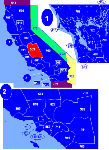
Area code 559
Encyclopedia
Central California
Central California, sometimes referenced as Mid-State, is an area of California south of the San Francisco Bay Area and north of Southern California...
, serving the counties of
Fresno
Fresno County, California
Fresno County is a county located in the Central Valley of the U.S. state of California, south of Stockton and north of Bakersfield. As of the 2010 census, it is the tenth most populous county in California with a population of 930,450, and the sixth largest in size with an area of . The county...
, Madera
Madera County, California
Madera County is a county of the U.S. state of California, located in the Central Valley and the Sierra Nevada north of Fresno County. It comprises the Madera-Chowchilla, CA Metropolitan Statistical Area. As of the 2010 census the population was 150,865...
, Kings
Kings County, California
Kings County is a county located in the Central Valley of the U.S. state of California. It is located in a rich agricultural region. Kings County is also home to NAS Lemoore, which is the U.S. Navy's newest and largest master jet air station. The county seat is Hanford...
, and Tulare
Tulare County, California
Tulare County is a county located in the Central Valley of the U.S. state of California, south of Fresno. Sequoia National Park is located in the county, as are part of Kings Canyon National Park, in its northeast corner , and part of Mount Whitney, on its eastern border...
. It was created on November 14, 1998, when the southern half of the area code 209
Area code 209
209 is the North American telephone area code for California that covers Stockton, Modesto, Turlock, Merced, Winton, Atwater, Livingston, Manteca, Ripon, Tracy, Lodi, Sonora, Los Banos, San Andreas, Mariposa, and Yosemite, as well as the northern San Joaquin Valley and the Sierra Foothills...
(in service since October, 26, 1957 at 12PM) reached full capacity.
Service
The 559 area code serves the Central California counties of FresnoFresno County, California
Fresno County is a county located in the Central Valley of the U.S. state of California, south of Stockton and north of Bakersfield. As of the 2010 census, it is the tenth most populous county in California with a population of 930,450, and the sixth largest in size with an area of . The county...
, Madera
Madera County, California
Madera County is a county of the U.S. state of California, located in the Central Valley and the Sierra Nevada north of Fresno County. It comprises the Madera-Chowchilla, CA Metropolitan Statistical Area. As of the 2010 census the population was 150,865...
, Kings
Kings County, California
Kings County is a county located in the Central Valley of the U.S. state of California. It is located in a rich agricultural region. Kings County is also home to NAS Lemoore, which is the U.S. Navy's newest and largest master jet air station. The county seat is Hanford...
, and Tulare
Tulare County, California
Tulare County is a county located in the Central Valley of the U.S. state of California, south of Fresno. Sequoia National Park is located in the county, as are part of Kings Canyon National Park, in its northeast corner , and part of Mount Whitney, on its eastern border...
. The major cities within the 559 area code region are Fresno
Fresno, California
Fresno is a city in central California, United States, the county seat of Fresno County. As of the 2010 census, the city's population was 510,365, making it the fifth largest city in California, the largest inland city in California, and the 34th largest in the nation...
, Coalinga
Coalinga, California
Coalinga is a city in Fresno County, California. The population was 13,380 at the 2010 census, up from 11,668 at the 2000 census. It is the site of both Pleasant Valley State Prison and Coalinga State Hospital. Coalinga is located southwest of Fresno, at an elevation of 673 feet .-Early...
, Clovis
Clovis, California
Clovis is a city in Fresno County, California, United States, northeast of Fresno. The population is estimated to be 97,218 as of September, 2011. Clovis is located northeast of downtown Fresno, at an elevation of 361 feet .-History:...
, Madera
Madera, California
Madera is a city in and the county seat of Madera County, California, United States. It is a principal city of the Madera–Chowchilla Metropolitan Statistical Area, which encompasses all of Madera County, and Metropolitan Fresno. It is located in California's San Joaquin Valley. As of the 2010...
, Sanger
Sanger, California
Sanger is a city in Fresno County, California, United States. The population was 24,270 at the 2010 census, up from 18,731 at the 2000 census. Sanger is located east-southeast of Fresno, at an elevation of 371 feet .- Geography :...
, Reedley
Reedley, California
Reedley is a city in Fresno County, California, United States. Reedley is located east-southeast of Fresno, at an elevation of 348 feet . The population at the 2010 census was 24,194. Its chief economic source is agriculture, particularly fruit and vegetable cultivation. The city is dubbed as...
, Dinuba
Dinuba, California
Dinuba is a city in Tulare County, California, United States. The population was 21,453 at the 2010 census. It is part of the Visalia Metropolitan Statistical Area according to the United States Census Bureau...
, Selma
Selma, California
Selma is a city in Fresno County, California. The population was 23,219 at the 2010 census, up from 19,240 at the 2000 census. Selma is located southeast of Fresno, at an elevation of 308 feet .-Geography:...
, Tulare
Tulare, California
Tulare is a city in Tulare County, California, United States. The population was 59,278 at the 2010 census.Just eight miles south of Visalia, it is part of the Census Bureau's designation of the Visalia Metropolitan Area. The city is named for the currently dry Tulare Lake, once the largest...
, Visalia
Visalia, California
Visalia is a Central California city situated in the heart of California’s agricultural San Joaquin Valley, approximately southeast of San Francisco and north of Los Angeles...
, Hanford
Hanford, California
Hanford is an important commercial and cultural center in the south central San Joaquin Valley and is the county seat of Kings County, California. It is the principal city of the Hanford-Corcoran, California Metropolitan Statistical Area , which encompasses all of Kings County, including the cities...
, Lemoore
Lemoore, California
Lemoore is a city in Kings County, California, United States. Lemoore is located west-southwest of Hanford, at an elevation of 230 feet . It is part of the Hanford–Corcoran Metropolitan Statistical Area...
, and Porterville
Porterville, California
Porterville is a city in the San Joaquin Valley, in Tulare County, California, United States. Porterville's population was 54,165 at the 2010 census. The city's population grew dramatically as the city annexed many properties and unincorporated areas in and around Porterville. Not included in the...
.
Fresno County
- AuberryAuberry, CaliforniaAuberry is a census-designated place in Fresno County, California, United States. The population was 2,369 at the 2010 census, up from 2,053 at the 2000 census...
- Big CreekBig Creek, CaliforniaBig Creek is a small census-designated place in Fresno County, California located in the Sierra Nevada Mountains on the north bank of Big Creek. It lies at an elevation of 4984 feet . Its population is 175...
- BiolaBiola, CaliforniaBiola is a census-designated place in Fresno County, California, United States. The population was 1,623 at the 2010 census, up from 1,037 at the 2000 census...
- BowlesBowles, CaliforniaBowles is a census-designated place in Fresno County, California, United States. The population was 166 at the 2010 census, down from 182 at the 2000 census...
- CalwaCalwa, CaliforniaCalwa is an unincorporated census-designated place in Fresno County, California, U.S. The population was 2,052 at the 2010 census, up from 762 at the 2000 census. Calwa is located south-southeast of downtown Fresno, at an elevation of 292 feet...
- Cantua CreekCantua Creek, CaliforniaCantua Creek is a census-designated place in Fresno County, California, United States. As of the 2010 census, the population was 466, down from the 655 reported at the 2000 census...
- CaruthersCaruthers, CaliforniaCaruthers is a census-designated place in Fresno County, California, United States. The population was 2,497 at the 2010 census, up from 2,103 at the 2000 census...
- ClovisClovis, CaliforniaClovis is a city in Fresno County, California, United States, northeast of Fresno. The population is estimated to be 97,218 as of September, 2011. Clovis is located northeast of downtown Fresno, at an elevation of 361 feet .-History:...
- CoalingaCoalinga, CaliforniaCoalinga is a city in Fresno County, California. The population was 13,380 at the 2010 census, up from 11,668 at the 2000 census. It is the site of both Pleasant Valley State Prison and Coalinga State Hospital. Coalinga is located southwest of Fresno, at an elevation of 673 feet .-Early...
- Del ReyDel Rey, CaliforniaDel Rey is a census-designated place in Fresno County, California, United States. The population was 1,639 at the 2010 census, up from 950 at the 2000 census...
- DunlapDunlap, CaliforniaDunlap is an unincorporated community in Fresno County, California. It lies at an elevation of 1919 feet . It has a population of 131. It is located approximately east of Fresno. St. Nicholas Ranch , a retreat center run by the Greek Orthodox Church, is a major attraction...
- EastonEaston, CaliforniaEaston is a census-designated place in Fresno County, California, United States. The population was 2,083 at the 2010 census, up from 1,966 at the 2000 census...
- FirebaughFirebaugh, CaliforniaFirebaugh is a city in Fresno County, California, United States. The population was 7,549 at the 2010 census, up from 5,743 as of the 2000 census. ZIP Code for the community is 93622 and the city is located inside area code 559. Firebaugh is located on the west side of the San Joaquin River west...
- FowlerFowler, CaliforniaFowler is a city in Fresno County, California, United States. It is located within the San Joaquin Valley. It has a strong agricultural community, with lush grape vineyards and expansive farmland. Fowler is located southeast of downtown Fresno, at an elevation of 308 feet...
- FresnoFresno, CaliforniaFresno is a city in central California, United States, the county seat of Fresno County. As of the 2010 census, the city's population was 510,365, making it the fifth largest city in California, the largest inland city in California, and the 34th largest in the nation...
- FriantFriant, CaliforniaFriant is a census-designated place in Fresno County, California, United States. The population was 549 at the 2010 census, down from 778 at the 2000 census. Friant is located north of Clovis, at an elevation of 344 feet .-Geography:Friant is located at...
- HuronHuron, CaliforniaHuron is a small city in Fresno County, California, in the United States. As of the 2010 census, the population was 6,754, up from 6,306 at the 2000 census. During the harvest season, the population swells to over 15,000 people due to the influx of migrant farm workers. Huron is located ...
- KermanKerman, CaliforniaKerman is a city at the intersection of State Route 180 and State Route 145 in Fresno County, California, USA. The population was 13,544 at the 2010 census. Kerman is located west of Fresno, at an elevation of 220 feet ....
- KingsburgKingsburg, CaliforniaKingsburg is a city in Fresno County, California. Kingsburg is located southeast of Selma at an elevation of 302 feet , on the banks of the Kings River. The city is half an hour away from Fresno, and two hours away from the California Central Coast and Sierra Nevada Mountain Range...
- KnowlesKnowles, CaliforniaKnowles is an unincorporated community in Madera County, California. It is located east of Raymond, at an elevation of 928 feet ....
- LanareLanare, CaliforniaLanare is a community and census-designated place in Fresno County, California, United States. The population was 589 at the 2010 census, up from 540 at the 2000 census. Lanare is located south-southwest of Fresno, at an elevation of 207 feet . The name is derived from Llewellyn A...
- LatonLaton, CaliforniaLaton is a census-designated place in Fresno County, California, United States. The population was 1,824 at the 2010 census, up from 1,236 at the 2000 census...
- MendotaMendota, CaliforniaMendota is a city in Fresno County, California, United States. The population was 11,014 at the 2010 census. The State Routes 180 and 33 run through the agricultural city. Mendota is located south-southeast of Firebaugh, at an elevation of 174 feet ....
- Mercey Hot SpringsMercey Hot Springs, CaliforniaMercey Hot Springs is an unincorporated community in Fresno County, California, about west-southwest of Fresno. It is a resort along Little Panoche Road located at the western edge of Fresno County. The unincorporated area is about ten driving miles west of Interstate 5...
- Orange CoveOrange Cove, CaliforniaOrange Cove is a small city in Fresno County, California, United States. The population was 9,078 at the 2010 census, up from 7,722 at the 2000 census. Almost all of Orange Cove's residents are Hispanic, many of whom are farmers...
- ParlierParlier, CaliforniaParlier is a city in Fresno County, California, United States. As of the 2010 census, the city had a total population of 9,494, down from 11,145 at the 2000 census. The city has one of the state's highest percentage of Latinos, a large majority of them are seasonal migrant laborers who arrive and...
- Pinedale
- PratherPrather, CaliforniaPrather is an unincorporated community in Fresno County, California. It is located northeast of Fresno, at an elevation of 1657 feet ....
- Raisin CityRaisin City, CaliforniaRaisin City is a census-designated place in Fresno County, California, United States. The population was 380 at the 2010 census, up from 165 at the 2000 census...
- ReedleyReedley, CaliforniaReedley is a city in Fresno County, California, United States. Reedley is located east-southeast of Fresno, at an elevation of 348 feet . The population at the 2010 census was 24,194. Its chief economic source is agriculture, particularly fruit and vegetable cultivation. The city is dubbed as...
- RiverdaleRiverdale, CaliforniaRiverdale is a census-designated place in Fresno County, California, United States. The population was 3,153 at the 2010 census, up from 2,416 at the 2000 census...
- RolindaRolinda, CaliforniaRolinda is a small agricultural unincorporated community in Fresno County, California. It is located on the Southern Pacific Railroad west of downtown Fresno, at an elevation of 253 feet . It is located along State Route 180. Official U.S. Geological Survey coordinates for the community are . The...
- San JoaquinSan Joaquin, CaliforniaSan Joaquin is a city in Fresno County, California, United States. The population was 4,001 at the 2010 census, up from 3,270 at the 2000 census. The nearest high school in the area is Tranquillity High School in Tranquillity...
- SangerSanger, CaliforniaSanger is a city in Fresno County, California, United States. The population was 24,270 at the 2010 census, up from 18,731 at the 2000 census. Sanger is located east-southeast of Fresno, at an elevation of 371 feet .- Geography :...
- SelmaSelma, CaliforniaSelma is a city in Fresno County, California. The population was 23,219 at the 2010 census, up from 19,240 at the 2000 census. Selma is located southeast of Fresno, at an elevation of 308 feet .-Geography:...
- Shaver LakeShaver Lake, CaliforniaShaver Lake is a census-designated place in Fresno County, California, United States. The population was 634 at the 2010 census, down from 705 at the 2000 census. Shaver Lake is on the southeast end of the lake of the same name, northeast of New Auberry, at an elevation of 5627 feet . The name...
- Squaw Valley
- TollhouseTollhouse, CaliforniaTollhouse is an unincorporated community in Fresno County, California. It lies at an elevation of 1919 feet . Tollhouse is located in the Sierra Nevadas, southwest of Shaver Lake....
- TranquillityTranquillity, CaliforniaTranquillity is a census-designated place in Fresno County, California, United States. The population was 799 at the 2010 census, down from 813 at the 2000 census. Tranquillity High School is the only high school in Tranquillity...
Kings County
- ArmonaArmona, CaliforniaArmona is a census-designated place in Kings County, California, United States. Armona is located west-southwest of Hanford, at an elevation of 239 feet . It is part of the Hanford–Corcoran Metropolitan Statistical Area. The population was 4,156 at the 2010 census...
- AvenalAvenal, CaliforniaAvenal is a city in Kings County, California, United States. Avenal is located southwest of Hanford, at an elevation of 807 feet . It is part of the Hanford–Corcoran Metropolitan Statistical Area , which encompasses all of Kings County. In area, it is the largest city in Kings County...
- CorcoranCorcoran, CaliforniaCorcoran is a city in Kings County, California, United States. Corcoran is located south-southeast of Hanford, at an elevation of 207 feet . It is part of the Hanford–Corcoran, Metropolitan Statistical Area...
- HanfordHanford, CaliforniaHanford is an important commercial and cultural center in the south central San Joaquin Valley and is the county seat of Kings County, California. It is the principal city of the Hanford-Corcoran, California Metropolitan Statistical Area , which encompasses all of Kings County, including the cities...
- HardwickHardwick, CaliforniaHardwick is a census-designated place in Kings County, California, United States. It is part of the Hanford–Corcoran Metropolitan Statistical Area. The population was 138 at the 2010 Census. The village is located northwest of Hanford, at an elevation of 249 feet .Hardwick is in the San...
- Home GardenHome Garden, CaliforniaHome Garden is a census-designated place in Kings County, California, United States. The community is about southeast of the city of Hanford. It is part of the Hanford–Corcoran Metropolitan Statistical Area...
- Kettleman CityKettleman City, CaliforniaKettleman City is a census-designated place in Kings County, California, United States. Kettleman City is located southwest of Hanford, at an elevation of 253 feet . It is part of the Hanford–Corcoran Metropolitan Statistical Area. The population was 1,439 at the 2010 census, down from...
- Lemoore StationLemoore Station, CaliforniaLemoore Station is a census-designated place in Naval Air Station Lemoore, Kings County, California, United States. It is part of the Hanford–Corcoran Metropolitan Statistical Area...
- LemooreLemoore, CaliforniaLemoore is a city in Kings County, California, United States. Lemoore is located west-southwest of Hanford, at an elevation of 230 feet . It is part of the Hanford–Corcoran Metropolitan Statistical Area...
- StratfordStratford, CaliforniaStratford is a census-designated place in Kings County, California, United States. Stratford is located southwest of Hanford, at an elevation of 203 feet . It is part of the Hanford–Corcoran Metropolitan Statistical Area...
Madera County
- AhwahneeAhwahnee, CaliforniaAhwahnee is a census-designated place in Madera County, California. It is located west of Yosemite Forks, at an elevation of 2326 feet . The population was 2,246 at the 2010 census....
- Bonadelle Ranchos-Madera RanchosBonadelle Ranchos-Madera Ranchos, CaliforniaBonadelle Ranchos-Madera Ranchos is a census-designated place in Madera County, California, United States. It is part of the Madera–Chowchilla Metropolitan Statistical Area...
- ChowchillaChowchilla, CaliforniaChowchilla is a city in Madera County, California, United States. Chowchilla is located northwest of Madera, at an elevation of 240 feet . It is a principal city of the Madera–Chowchilla Metropolitan Statistical Area. The population was 18,720 at the 2010 census, up from 11,127 at the 2000...
- CoarsegoldCoarsegold, CaliforniaCoarsegold is a census-designated place in Madera County, California. It is located south-southwest of Yosemite Forks, at an elevation of 2218 feet...
- Fish CampFish Camp, CaliforniaFish Camp is a census-designated place in Mariposa County, California. It is located east of Mariposa, at an elevation of 5062 feet . The population was 59 at the 2010 census....
- Madera AcresMadera Acres, CaliforniaMadera Acres is a census-designated place in Madera County, California, United States. It is part of the Madera–Chowchilla Metropolitan Statistical Area...
- MaderaMadera, CaliforniaMadera is a city in and the county seat of Madera County, California, United States. It is a principal city of the Madera–Chowchilla Metropolitan Statistical Area, which encompasses all of Madera County, and Metropolitan Fresno. It is located in California's San Joaquin Valley. As of the 2010...
- MillertonMillerton, Madera County, CaliforniaMillerton was the original county seat of Fresno County, formed in 1856. The county was much larger than it is today, comprising its current area plus all of what became Madera County and parts of what are now San Benito, Tulare, Kings, Inyo, and Mono counties.Millerton, then on the banks of the...
- North ForkNorth Fork, CaliforniaNorth Fork is an unincorporated community in Madera County, California. It is located east of Raymond, at an elevation of 2638 feet .It is miles south east of Bass Lake and from Oakhurst. North Fork is also home of the Mono Indian Museum and the starting point of the Sierra scenic byway...
- OakhurstOakhurst, CaliforniaOakhurst is a census-designated place in Madera County, California, south of the entrance to Yosemite National Park, in the foothills of the Sierra Nevada mountain range. Oakhurst is located on the Fresno River south-southwest of Yosemite Forks, at an elevation of 2274 feet...
- ParksdaleParksdale, CaliforniaParksdale is a census-designated place in Madera County, California, United States. It is part of the Madera–Chowchilla Metropolitan Statistical Area...
- ParkwoodParkwood, CaliforniaParkwood is a census-designated place in Madera County, California, United States. It is part of the Madera–Chowchilla Metropolitan Statistical Area...
- RaymondRaymond, CaliforniaRaymond is an unincorporated community in Madera County, California. It is located north-northeast of Madera, at an elevation of 948 feet ....
- Yosemite LakesYosemite Lakes, CaliforniaYosemite Lakes is a census-designated place in Madera County, California, United States. It is part of the Madera–Chowchilla Metropolitan Statistical Area...
Tulare County
- AlpaughAlpaugh, CaliforniaAlpaugh is a census-designated place in Tulare County, California, United States. The population was 1,026 at the 2010 census, up from 761 at the 2000 census....
- BadgerBadger, CaliforniaBadger is an unincorporated town located in Tulare County in California. It has a population of 140. The zip code is 93603 and the area code 559....
- CutlerCutler, CaliforniaCutler is a community and census-designated place in Tulare County, California, United States. The population was 5,000 at the 2010 census, up from 4,491 at the 2000 census.-Geography:Cutler is located at ....
- DinubaDinuba, CaliforniaDinuba is a city in Tulare County, California, United States. The population was 21,453 at the 2010 census. It is part of the Visalia Metropolitan Statistical Area according to the United States Census Bureau...
- DucorDucor, CaliforniaDucor is a census-designated place in Tulare County, California, United States. The population was 612 at the 2010 census, up from 504 at the 2000 census.-Geography:Ducor is located at ....
- East OrosiEast Orosi, CaliforniaEast Orosi is a census-designated place in Tulare County, California, United States. The population was 495 at the 2010 census, up from 426 at the 2000 census.-Geography:East Orosi is located at ....
- East PortervilleEast Porterville, CaliforniaEast Porterville is a census-designated place in Tulare County, California, United States. The population was 6,767 at the 2010 census, up from 6,730 at the 2000 census.-Geography:East Porterville is located at ....
- ExeterExeter, CaliforniaExeter is a city in Tulare County, California, United States. It is situated near the foothills of the Sierra Nevada Mountain Range. The population was 10,334 at the 2010 census....
- FarmersvilleFarmersville, CaliforniaFarmersville is a suburb of Visalia, in Tulare County, California, United States. The population was 10,588 at the 2010 census, up from 8,737 at the 2000 census.-Geography:Farmersville is located at ....
- GoshenGoshen, CaliforniaGoshen is a census-designated place in Visalia, Tulare County, California, United States. The population was 3,006 at the 2010 census, up from 2,394 at the 2000 census...
- IvanhoeIvanhoe, CaliforniaIvanhoe is a census-designated place in Tulare County, California, United States. The population was 4,495 at the 2010 census, up from 4,474 at the 2000 census.-Geography:Ivanhoe is located at ....
- Lemon CoveLemon Cove, CaliforniaLemon Cove is a census-designated place in Tulare County, California, United States. The population was 308 at the 2010 census, up from 298 at the 2000 census.-Geography and ecology:...
- LindsayLindsay, CaliforniaLindsay is a city in Tulare County, California, United States. The population was 11,768 at the 2010 census. Lindsay is located southeast of Visalia and is considered part of the Visalia Metropolitan Area by the United States Census Bureau.-History:...
- LondonLondon, CaliforniaLondon is a census-designated place in Tulare County, California, United States. The population was 1,869 at the 2010 census, up from 1,848 at the 2000 census .-Geography:London is located at ....
- OrosiOrosi, CaliforniaOrosi is a census-designated place in Tulare County, California, United States. The population was 8,770 at the 2010 census, up from 7,318 at the 2000 census.-Geography:Orosi is located at ....
- PixleyPixley, CaliforniaPixley is a census-designated place in Tulare County, California, United States. The population was 3,310 at the 2010 census, up from 2,586 at the 2000 census...
- Poplar-Cotton CenterPoplar-Cotton Center, CaliforniaPoplar-Cotton Center is a census-designated place in Tulare County, California, United States. The population was 2,470 at the 2010 census, up from 1,496 at the 2000 census...
- PortervillePorterville, CaliforniaPorterville is a city in the San Joaquin Valley, in Tulare County, California, United States. Porterville's population was 54,165 at the 2010 census. The city's population grew dramatically as the city annexed many properties and unincorporated areas in and around Porterville. Not included in the...
- SpringvilleSpringville, CaliforniaSpringville is a census-designated place in Tulare County, California, United States. The population was 934 at the 2010 census, down from 1,109 at the 2000 census.-Geography:Springville is located at ....
- StrathmoreStrathmore, CaliforniaStrathmore is a census-designated place in Tulare County, California, United States. The population was 2,819 at the 2010 census, up from 2,584 at the 2000 census.-History:...
- Terra BellaTerra Bella, CaliforniaTerra Bella is a census-designated place in Tulare County, California, United States. The population was 3,310 at the 2010 census, down from 3,466 at the 2000 census.-Geography:Terra Bella is located at ....
- Three RiversThree Rivers, CaliforniaThree Rivers is a census-designated place in Tulare County, California, United States. The population was 2,182 at the 2010 census, down from 2,248 at the 2000 census....
- TiptonTipton, CaliforniaTipton is a census-designated place in Tulare County, California, United States. The population was 2,543 at the 2010 census, up from 1,790 at the 2000 census.-Geography:Tipton is located at ....
- TraverTraver, CaliforniaTraver is a census-designated place in Tulare County, California, United States. The population was 713 at the 2010 census, down from 732 at the 2000 census.-Geography:Traver is located at ....
- TulareTulare, CaliforniaTulare is a city in Tulare County, California, United States. The population was 59,278 at the 2010 census.Just eight miles south of Visalia, it is part of the Census Bureau's designation of the Visalia Metropolitan Area. The city is named for the currently dry Tulare Lake, once the largest...
- VisaliaVisalia, CaliforniaVisalia is a Central California city situated in the heart of California’s agricultural San Joaquin Valley, approximately southeast of San Francisco and north of Los Angeles...
- WoodlakeWoodlake, CaliforniaWoodlake is a city in Tulare County, California, United States. The population was 7,279 at the 2010 census, up from 6,651 at the 2000 census.-Geography:Woodlake is located at ....
- WoodvilleWoodville, CaliforniaWoodville is a census-designated place in Tulare County, California, United States. The population was 1,740 at the 2010 census, up from 1,678 at the 2000 census.-Geography:Woodville is located at ....
History
Like many other regions that had experienced area code changes during the area code boom of the 1990s, both 559 and 209 were in the early planning stages of relief, potentially creating the need for introduction of further new area codes. Yet by 2002, number blocking was being enforced in the 209 and 559 area codes. Instead of handing out numbers in blocks of 10,000 to private companies (as had been normal practice since the beginning of the NANP in 1947), only 1,000 numbers would be handed out at a time. For example, instead of granting Pacific BellPacific Bell
The Pacific Telephone and Telegraph Company was the name of the Bell System's telephone operations in California. It gained in size by acquiring smaller telephone companies along the Pacific coast, such as Sunset Telephone & Telegraph in 1917...
all numbers (559) 330-xxxx, only numbers (559) 330-0xxx, or (559) 330-1xxx or (559) 330-2xxx, and so on, would be granted.
See also
- List of California area codes
- List of NANP area codes
- North American Numbering PlanNorth American Numbering PlanThe North American Numbering Plan is an integrated telephone numbering plan administered by Neustar which encompasses 24 countries and territories, including the United States and its territories, Canada, Bermuda, and 16 nations of the Caribbean...
Sources
External links
- North American Numbering Plan Administration
- Area code map of California from whitepages.com
- 559 Area Code from AreaCodeDownload.com