

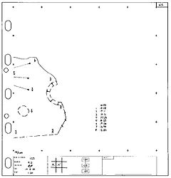
Archaeological plan
Encyclopedia
Technical drawing
Technical drawing, also known as drafting or draughting, is the act and discipline of composing plans that visually communicate how something functions or has to be constructed.Drafting is the language of industry....
of feature
Feature (archaeology)
Feature in archaeology and especially excavation has several different but allied meanings. A feature is a collection of one or more contexts representing some human non-portable activity that generally has a vertical characteristic to it in relation to site stratigraphy. Examples of features are...
s (and artifact
Artifact (archaeology)
An artifact or artefact is "something made or given shape by man, such as a tool or a work of art, esp an object of archaeological interest"...
s) in the horizontal plane.
Overview
Archaeological plan can either take the form of- a "multi context" plan, which is drawn with many contextArchaeological contextIn archaeology, not only the context of a discovery is a significant fact, but the formation of the context is as well. An archaeological context is an event in time which has been preserved in the archaeological record. The cutting of a pit or ditch in the past is a context, whilst the material...
s on it to show relationships between these features as part of some phaseArchaeological phaseArchaeological phase and phasing refers to the logical reduction of contexts recorded during excavation to near contemporary archaeological horizons that represent a distinct "phase" of previous land use. These often but not always will be a representation of a former land surface or occupation...
, or - alternatively a single context plan with a single feature is drawn .
Excavated features are drawn in three dimensions with the help of drawing conventions such as hachures. Single context planning developed by the Museum of London
Museum of London
The Museum of London documents the history of London from the Prehistoric to the present day. The museum is located close to the Barbican Centre, as part of the striking Barbican complex of buildings created in the 1960s and 70s as an innovative approach to re-development within a bomb damaged...
has become the professional norm. The basic advantage of single context planning is context plans draw on "transparent perma-trace paper" can be overlaid for re-interpretation at a later date.
Multi-context Plans as opposed to single context plans can be made of complete sites, trenches or individual features. In the United Kingdom
United Kingdom
The United Kingdom of Great Britain and Northern IrelandIn the United Kingdom and Dependencies, other languages have been officially recognised as legitimate autochthonous languages under the European Charter for Regional or Minority Languages...
, the scale
Scale (ratio)
The scale ratio of some sort of model which represents an original proportionally is the ratio of a linear dimension of the model to the same dimension of the original. Examples include a 3-dimensional scale model of a building or the scale drawings of the elevations or plans of a building. In such...
of the plans is usually 1:20. They are linked to the site recording system by the inclusion of known grid points and height readings, taken with a dumpy level
Dumpy level
A dumpy level, builder's auto level, leveling instrument, or automatic level is an optical instrument used to establish or check points in the same horizontal plane...
or a total station
Total station
A total station is an electronic/optical instrument used in modern surveying. The total station is an electronic theodolite integrated with an electronic distance meter to read slope distances from the instrument to a particular point....
(see surveying
Surveying
See Also: Public Land Survey SystemSurveying or land surveying is the technique, profession, and science of accurately determining the terrestrial or three-dimensional position of points and the distances and angles between them...
). Excavation of a site by the removal of human made deposits in the reverse order they were created is the preferred method of excavation and is referred to as stratigraphic area excavation "in plan" as opposed to excavation "in section"
Archaeological section
In archaeology a section is a view in part of the archaeological sequence showing it in the vertical plane, as a cross section, and thereby illustrating its profile and stratigraphy. This may make it easier to view and interpret as it developed over time....
. Plan and section drawings have an interpretive function as well as being part of the recording system, because the draughts-person makes conscious decisions about what should be included or emphasised.
Archaeological plan topics
The grid
It is common and good practice on excavations to lay out a grid of 5m squares so as to facilitate planning. This grid is marked out on-site with grid pegs that form the baselines for tapes and other planning tools to aid the drawing of plans. It is also common practice that planning is done for each context on a separate piece of perma-trace that conforms to these 5m grid squares. This is part of the single context recordingSingle context recording
Single context recording was initially developed by Ed Harris and Patrick Ottaway in 1976, from a suggestion by Lawrence Keene. It was further developed by the Department of Urban Archaeology from where it was then exported, in the mid 1980s by Pete Clarke to the Scottish Urban Archaeological...
system (see Fig 1.) The site grid should be tied into a national geomatic database such as the Ordnance survey
Ordnance Survey
Ordnance Survey , an executive agency and non-ministerial government department of the Government of the United Kingdom, is the national mapping agency for Great Britain, producing maps of Great Britain , and one of the world's largest producers of maps.The name reflects its creation together with...
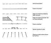
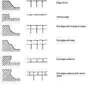
Planning drawing conventions
Archaeological planners use various symbols to denote characteristics of features and contexts and while conventions vary depending on practitioner, the following are representative:Pre-excavation and base plans
On sites with little stratigraphic depth, a pre-excavation multi-context plan is sometimes made of all visible features before any excavation is carried out. This helps in planning strategy since problems of stratigraphy on rural sites are minimal as featuresFeature (archaeology)
Feature in archaeology and especially excavation has several different but allied meanings. A feature is a collection of one or more contexts representing some human non-portable activity that generally has a vertical characteristic to it in relation to site stratigraphy. Examples of features are...
often cut
Cut (archaeology)
In Archaeology and archeological stratification a cut or truncation is a context that represents a moment in time when other archaeological deposits were removed for the creation of some feature such as a ditch or pit...
into the natural
Archaeological natural
Natural in archaeology is a term to denote a horizon in the stratigraphic record representing the point before which there is no anthropogenic activity on site and the archaeological record ends. Natural is often the underlying geological makeup of the site and is formed by geological processes...
minimizing issues of inter-cutting features
Feature (archaeology)
Feature in archaeology and especially excavation has several different but allied meanings. A feature is a collection of one or more contexts representing some human non-portable activity that generally has a vertical characteristic to it in relation to site stratigraphy. Examples of features are...
. Conversely, planning a multi-context urban site is difficult to achieve on a multi-context plan as the features and deposits when planned will obscure each other on the same planning sheet.
Critics of pre-excavation planning
Pre-excavation plans have been critiqued as being of limited use on urban or deeply stratified sites and have also been attacked in professional archeology where they have been described as a misused tool of the unscrupulous operators to give the impression the archaeological recordArchaeological record
The archaeological record is the body of physical evidence about the past. It is one of the most basic concepts in archaeology, the academic discipline concerned with documenting and interpreting the archaeological record....
for a given site has been dealt with adequately.
This critical point of view contends, that comparisons between pre and post-excavation plans can demonstrate that a site has not been comprehensively excavated on the basis of a pre-ex plan alone. In many cases there is a pronounced difference between the two phases of planning. Although many features may be visible at ground level following machining, it is often the case that the true limits of features are not so initially discernible until the area of the feature is fully cleaned and subsequently excavated revealing further features and relationships
Relationship (archaeology)
An archaeological relationship is the position in space and by implication, in time, of an object or context with respect to another. This is determined, not by linear measurement but by determining the sequence of their deposition - which arrived before the other...
lower in the sequence
Sequence (archaeological)
The archaeological sequence or sequence for short, on a specific archaeological site can be defined on two levels of rigour.# Normally it is adequate to equate it to archaeological record. However, the two terms are not exactly interchangeable...
.
See also
- Archaeological contextArchaeological contextIn archaeology, not only the context of a discovery is a significant fact, but the formation of the context is as well. An archaeological context is an event in time which has been preserved in the archaeological record. The cutting of a pit or ditch in the past is a context, whilst the material...
- Archaeological illustrationArchaeological illustrationArchaeological Illustration is a form of technical illustration that records material derived from an archaeological context graphically. - Overview :Archaeological Illustration encompasses a number of sub disciplines. These are:...
- Archaeological field surveyArchaeological field surveyArchaeological field survey is the method by which archaeologists search for archaeological sites and collect information about the location, distribution and organization of past human cultures across a large area...
- Archaeological sectionArchaeological sectionIn archaeology a section is a view in part of the archaeological sequence showing it in the vertical plane, as a cross section, and thereby illustrating its profile and stratigraphy. This may make it easier to view and interpret as it developed over time....
- Excavation (archaeology)
- Cut (archaeology)Cut (archaeology)In Archaeology and archeological stratification a cut or truncation is a context that represents a moment in time when other archaeological deposits were removed for the creation of some feature such as a ditch or pit...
- Feature (archaeology)Feature (archaeology)Feature in archaeology and especially excavation has several different but allied meanings. A feature is a collection of one or more contexts representing some human non-portable activity that generally has a vertical characteristic to it in relation to site stratigraphy. Examples of features are...
- GeomaticsGeomaticsGeomatics is the discipline of gathering, storing, processing, and delivering geographic information, or spatially referenced information.-Overview and etymology:...
- Harris matrixHarris matrixThe Harris matrix is a tool used to depict the temporal succession of archaeological contexts and thus the sequence of deposition on a 'dry land' archaeological site. The matrix reflects the relative position and stratigraphic contacts of observable stratigraphic units, or contexts. The Matrix was...
- Single context recordingSingle context recordingSingle context recording was initially developed by Ed Harris and Patrick Ottaway in 1976, from a suggestion by Lawrence Keene. It was further developed by the Department of Urban Archaeology from where it was then exported, in the mid 1980s by Pete Clarke to the Scottish Urban Archaeological...
- Site planSite planA site plan is an architectural plan, landscape architecture document, and a detailed engineering drawing of proposed improvements to a given lot...
Further reading
- The MoLAS archaeological site manual MoLAS, London 1994. ISBN 0-904818-40-3. Rb 128pp. bl/wh