
Arbury
Encyclopedia
Arbury is a district and electoral ward of the city of Cambridge
, England
. The ward borders the following other wards (from North, proceeding clockwise): Histon
, King's Hedges
, West Chesterton, Market and Castle
.
) and was known as Hardburgh Camp by the 13th century. This later corrupted to Arborough and then Arbury. The earthwork was formerly around 100 metres in length, though its western half (extending into Impington) was no longer visible by the start of the 19th century. It is thought to have been an undefended Iron Age
enclosure to protect animals from predators.
In medieval times, the area was common land, and local peasants were permitted to graze their sheep on the meadow between Lammas
to Lady Day
. In the 17th and 18th centuries the meadows were dug for earth to make bricks.
Arbury was historically part of the parish
of Chesterton, the area was developed by Cambridge City Council
from 1957 as a housing estate
of around 100 acres.
Arbury Court houses a post office, library, supermarket and other local shops. The Carlton Way public house lies on its namesake road, which follows the route of the Roman Akeman Street
. Not all areas of Cambridge are as prosperous as many believe and Arbury is an example of a lower income neighbourhood. Crime rates however are lower here than in many parts of central Cambridge.
Isaac Pearson, the uncle of the Victorian novelist George Eliot lived in Arbury.
Cambridge
The city of Cambridge is a university town and the administrative centre of the county of Cambridgeshire, England. It lies in East Anglia about north of London. Cambridge is at the heart of the high-technology centre known as Silicon Fen – a play on Silicon Valley and the fens surrounding the...
, England
England
England is a country that is part of the United Kingdom. It shares land borders with Scotland to the north and Wales to the west; the Irish Sea is to the north west, the Celtic Sea to the south west, with the North Sea to the east and the English Channel to the south separating it from continental...
. The ward borders the following other wards (from North, proceeding clockwise): Histon
Histon
Histon and Impington are villages in Cambridgeshire, England, They are situated just north of Cambridge with the main bulk of the settlements being separated from the city by the A14 road ....
, King's Hedges
King's Hedges
King's Hedges is an electoral ward in the north of the city of Cambridge, England.-History:The open land to the north of Cambridge that now comprises King's Hedges was known as Albrach from as early as the 13th century...
, West Chesterton, Market and Castle
Castle, Cambridge
Castle is a district and electoral ward of the city of Cambridge, England. It is named after the former Cambridge Castle which once stood on Castle Mound....
.
History
The area has been occupied since at least Roman times. In the 1950s, stone coffins from the 2nd century were discovered, as well as the remains of a Roman villa and mausoleum. In medieval times, a decaying circular earthwork of unknown age was visible just to the north of where Arbury Road meets Histon Road (now part of Orchard ParkOrchard Park, Cambridgeshire
Orchard Park, previously known as Arbury Park and before that Arbury Camp, is a district and civil parish of South Cambridgeshire, England, contiguous with the city of Cambridge...
) and was known as Hardburgh Camp by the 13th century. This later corrupted to Arborough and then Arbury. The earthwork was formerly around 100 metres in length, though its western half (extending into Impington) was no longer visible by the start of the 19th century. It is thought to have been an undefended Iron Age
Iron Age
The Iron Age is the archaeological period generally occurring after the Bronze Age, marked by the prevalent use of iron. The early period of the age is characterized by the widespread use of iron or steel. The adoption of such material coincided with other changes in society, including differing...
enclosure to protect animals from predators.
In medieval times, the area was common land, and local peasants were permitted to graze their sheep on the meadow between Lammas
Lammas
In some English-speaking countries in the Northern Hemisphere, August 1 is Lammas Day , the festival of the wheat harvest, and is the first harvest festival of the year. On this day it was customary to bring to church a loaf made from the new crop...
to Lady Day
Lady Day
In the western Liturgical year, Lady Day is the traditional name of the Feast of the Annunciation of the Blessed Virgin in some English speaking countries. It is the first of the four traditional English quarter days. The "Lady" was the Virgin Mary. The term derives from Middle English, when some...
. In the 17th and 18th centuries the meadows were dug for earth to make bricks.
Arbury was historically part of the parish
Parish
A parish is a territorial unit historically under the pastoral care and clerical jurisdiction of one parish priest, who might be assisted in his pastoral duties by a curate or curates - also priests but not the parish priest - from a more or less central parish church with its associated organization...
of Chesterton, the area was developed by Cambridge City Council
Cambridge City Council
Cambridge City Council may refer to:* Cambridge City Council, England* Cambridge City Council, Massachusetts, USA* Cambridge, Ontario City Council, Canada...
from 1957 as a housing estate
Housing estate
A housing estate is a group of buildings built together as a single development. The exact form may vary from country to country. Accordingly, a housing estate is usually built by a single contractor, with only a few styles of house or building design, so they tend to be uniform in appearance...
of around 100 acres.
Local life
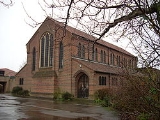
The community are served by the parish church of the Good Shepherd, a red brick church designed by S. E. Dykes Bower. The chancel was built in 1958 and the nave in 1963-4. Opened in 1963, it became the parish church of its own parish in 1969. The Arbury community centre opened in 1974, which is also home to the Arbury Community Church.Arbury Court houses a post office, library, supermarket and other local shops. The Carlton Way public house lies on its namesake road, which follows the route of the Roman Akeman Street
Akeman Street
Akeman Street was a major Roman road in England that linked Watling Street with the Fosse Way. Its junction with Watling Steet was just north of Verulamium and that with the Fosse Way was at Corinium Dobunnorum...
. Not all areas of Cambridge are as prosperous as many believe and Arbury is an example of a lower income neighbourhood. Crime rates however are lower here than in many parts of central Cambridge.
Isaac Pearson, the uncle of the Victorian novelist George Eliot lived in Arbury.