

Arastradero Preserve
Encyclopedia
Open space reserve
Open space reserve, open space preserve, and open space reservation, are planning and conservation ethics terms used to describe areas of protected or conserved land or water on which development is indefinitely set aside...
, is a nature preserve that protects most of the Arastradero Creek
Arastradero Creek
Arastradero Creek is a mainly seasonal generally north by northeastward-flowing stream originating in the Palo Alto foothills of the Santa Cruz Mountains in Santa Clara County, California, United States...
watershed. The preserve is owned and operated by the City of Palo Alto, in the city of Palo Alto, California
Palo Alto, California
Palo Alto is a California charter city located in the northwest corner of Santa Clara County, in the San Francisco Bay Area of California, United States. The city shares its borders with East Palo Alto, Mountain View, Los Altos, Los Altos Hills, Stanford, Portola Valley, and Menlo Park. It is...
, USA. The main parking lot hosts an Interpretive Center and is located at 1530 Arastradero Road (37°23'13" N, 122°10'29" W).
Description
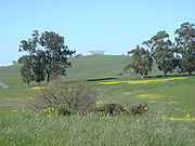
Arastradero Preserve is a preserve located in and managed by the city of Palo Alto, California. Consisting of rolling savannaSavanna
A savanna, or savannah, is a grassland ecosystem characterized by the trees being sufficiently small or widely spaced so that the canopy does not close. The open canopy allows sufficient light to reach the ground to support an unbroken herbaceous layer consisting primarily of C4 grasses.Some...
grassland hills and evergreen forest
Evergreen forest
An temperate evergreen forest is a forest consisting entirely or mainly of evergreen trees that retain green foliage all year round. Such forests exist in the tropics primarily as broadleaf evergreens, and in temperate and boreal latitudes primarily as coniferous evergreens.-Tropical evergreen...
s, the preserve varies in elevation from 275 feet (83.8 m) in the northeast to 775 feet (236.2 m) in the southwest. The preserve contains an abundance of wildlife, including deer
Deer
Deer are the ruminant mammals forming the family Cervidae. Species in the Cervidae family include white-tailed deer, elk, moose, red deer, reindeer, fallow deer, roe deer and chital. Male deer of all species and female reindeer grow and shed new antlers each year...
, bobcats, coyotes, and many species of birds. The Pearson-Arastradero Preserve has 10.25 miles (16.5 km) of trails for hiking
Hiking
Hiking is an outdoor activity which consists of walking in natural environments, often in mountainous or other scenic terrain. People often hike on hiking trails. It is such a popular activity that there are numerous hiking organizations worldwide. The health benefits of different types of hiking...
, biking and horseback riding. While many of the trails are open year-round, some trails are designated as "seasonal" and are closed at the trailhead
Trailhead
A trailhead is the point at which a trail begins, where the trail is often intended for hiking, biking, horseback riding, or off-road vehicles...
temporarily after heavy rain
Rain
Rain is liquid precipitation, as opposed to non-liquid kinds of precipitation such as snow, hail and sleet. Rain requires the presence of a thick layer of the atmosphere to have temperatures above the melting point of water near and above the Earth's surface...
. The Preserve and the surrounding area are habitats for the California mountain lion. There have been credible reports of mountain lion sightings in these areas recently. There have also been a number of reports of a lion(s) exhibiting an atypical curiosity towards people walking dogs in the Preserve.
There are three gates (labeled A, B, and C) into the preserve, though public parking is available only at Gate A on the North side. The park is also accessible from a pedestrian footpath that leads out the residential area off of the street Paseo del Roble.
The Preserve protects Arastradero Creek
Arastradero Creek
Arastradero Creek is a mainly seasonal generally north by northeastward-flowing stream originating in the Palo Alto foothills of the Santa Cruz Mountains in Santa Clara County, California, United States...
, which flows into Matadero Creek
Matadero Creek
Matadero Creek is a stream originating in the foothills of the Santa Cruz Mountains in Santa Clara County, California, United States. The creek flows in a northeasterly direction for until it enters the Palo Alto Flood Basin, then the Mayfield Slough and then southwest San Francisco Bay...
at the junction of Arastradero Road and Page Mill Road. Near the East side about a quarter mile south of the entrance is Arastradero Lake, one of two bodies of water within the preserve. The lake is also about .15 miles from the Paseo del Roble entrance.
Trails, Features and Maps
The trails at Arastradero Preserve include Acorn, Arastradeo Creek, Bay Laurel, Bowl Loop, Juan Bautista de Anza, Meadowlark, Ohlone, Paseo del Roble, Portola Pastures, Redtail Loop, Wild Rye, Woodland Star, and Woodrat. There are also unmarked and/or closed trails in the preserve.A map of the preserve can be found on the City of Palo Alto web site.
Restoration and Stewardship Activities
ActerraActerra
Acterra: Action for a Sustainable Earth is a nonprofit environmental education and action organization based in Palo Alto, California.Acterra's annual budget for FY 2007-08 was $918,604. The organization has approximately 1,000 paid members and donors....
, a local environmental nonprofit, has run a collaborative stewardship program on the Preserve in cooperation with the City of Palo Alto since 1997. Volunteers and Acterra staff work to improve the Preserve by eliminating invasive weeds such as non-native thistles, by planting native species such as blue wild rye
Elymus glaucus
Elymus glaucus is a species of wild rye known by the common name blue wild rye. This grass is native to North America from Alaska to New York to northern Mexico...
and native oaks, and by building trails.
Surroundings and History
Portions of Arastradero Preserve border Foothill Park (on the South side), the Palo Alto Golf Course (on the East side), open land owned by Stanford University (to the North), and one of the campuses of Palo Alto University (to the West). From the hills on the North Side, one can see Felt Lake which is not visible from any other public land. Because most of the golf course in on a flat mesa at a higher elevation than the preserve, the golf course is largely invisible from the preserve.There remains a small piece of private property adjacent to Arastradero Road surrounded on all sides by the preserve which currently has no structures. There had been a private home deep within the preserve until the late 1990s which has now been torn down.
In 2006 a small visitor's center was erected near the parking lot entrance which contains a miniature scale model of the park and exhibits explaining the ecology, flora, and fauna of the region.