
Ar'ara
Encyclopedia
'Ar'ara ("The juniper tree"), is an Israeli Arab
town
in the Wadi Ara
region in the Galilee
. It is located south of Umm al-Fahm
just northwest of the Green Line
and is part of the Triangle
. In 2009, the population was 16,700.
period by Ar'ara have been excavated, revealing clay lamps and glass vessels and beads, commonly used in the 1st to 4th century C.E.. A few clay fragments from the Mamluk
period have also been found at the same location.
In the Crusader
period, the place was known as "Castellum Arearum". In the land-allocation made by sultan Baybars in 663 H. (1265-1266 C.E.), Ar'ara was shared between his amirs Ala' al-Din and Sayf al-Din Bayhaq al-Baghdadi.
Ar'ara, like the rest of Palestine, was incorporated into the Ottoman Empire
in 1517, and in 1596, Ar'ara appeared in Ottoman
tax registers as being in the Nahiya of Shara of the Liwa
of Lajjun
. It had a population of 8 Muslim households and paid taxes on wheat, barley, summercrops, olives, and goats or beehives.
By the eighteenth century, the village remained in the administrative district of Lajjun, but the revenue of the place was farmed for the Mutasarrıf
of Jaffa
. In the late nineteenth century, the site was described as:
At the time of the 1931 census
, Ar'ara had 150 occupied houses and a population of 971 Muslims.
Ar'ara was transferred from Jordanian to Israeli jurisdiction in 1949 under the Rhodes
armistice agreements. The neighboring village of ʿAra
was merged with Ar'ara in 1985.
In 1945, Ar'ara and Arah had a population of 2,290 and a land area of 29,537 dunum
s. By 1962 the area had been reduced to 7,269 dunums, partly due to expropriations of 8,236 dunums by the Israeli government in 1953–54. One case of expropriation from a private landowner named Younis became a test case before the High Court of Israel in 1953. The land had been confiscated by the government without notifying the owner. In 1954 the court ruled that the law did not require the owner to be notified and did not provide a right for the owner to contest the confiscation in advance. This ruling and one other effectively ended the possibility of land owners using the courts to contest the confiscation of their land.
. The two top courses
are chamfer
ed towards the dome. On the north side is a doorway, and double window set inside shallow arch
es. There is also a set of windows on the west side. Inside there are three cenotaph
s, located east-west, close to the west wall. A mihrab
is located on the south wall. The date of the building is not known, but according to A. Petersen (who inspected the place in 1994), the architecture indicate an eighteenth or early nineteenth century date.
Arab citizens of Israel
Arab citizens of Israel refers to citizens of Israel who are not Jewish, and whose cultural and linguistic heritage or ethnic identity is Arab....
town
Local council (Israel)
Local councils are one of the three types of local government found in Israel, with the other two being cities and regional councils. As of 2003, there were 144 local councils in Israel, these being settlements which pass a minimum threshold enough to justify their operations as independent...
in the Wadi Ara
Wadi Ara
Wadi Ara or Nahal Iron , refers to an area within Israel that is mostly populated by Arabs. It is located northwest of the Green Line and is mostly within Israel's Haifa District. Today, Highway 65 runs through the wadi.-Geography:...
region in the Galilee
Galilee
Galilee , is a large region in northern Israel which overlaps with much of the administrative North District of the country. Traditionally divided into Upper Galilee , Lower Galilee , and Western Galilee , extending from Dan to the north, at the base of Mount Hermon, along Mount Lebanon to the...
. It is located south of Umm al-Fahm
Umm al-Fahm
Umm al-Fahm is a city in the Haifa District of Israel with a population of 43,300, nearly all of whom are Arab citizens of Israel. The city is situated on the Umm al-Fahm mountain ridge, the highest point of which is Mt. Iskander , overlooking Wadi Ara...
just northwest of the Green Line
Green Line (Israel)
Green Line refers to the demarcation lines set out in the 1949 Armistice Agreements between Israel and its neighbours after the 1948 Arab-Israeli War...
and is part of the Triangle
Triangle (Israel)
The Triangle , formerly referred to as the Little Triangle, is a concentration of Israeli Arab towns and villages adjacent to the Green Line, located in the eastern Sharon plain among the Samarian foothills; this area is located within the easternmost boundaries of both the Center District and...
. In 2009, the population was 16,700.
History
Burial complexes from the RomanAncient Rome
Ancient Rome was a thriving civilization that grew on the Italian Peninsula as early as the 8th century BC. Located along the Mediterranean Sea and centered on the city of Rome, it expanded to one of the largest empires in the ancient world....
period by Ar'ara have been excavated, revealing clay lamps and glass vessels and beads, commonly used in the 1st to 4th century C.E.. A few clay fragments from the Mamluk
Mamluk Sultanate (Cairo)
The Mamluk Sultanate of Egypt was the final independent Egyptian state prior to the establishment of the Muhammad Ali Dynasty in 1805. It lasted from the overthrow of the Ayyubid Dynasty until the Ottoman conquest of Egypt in 1517. The sultanate's ruling caste was composed of Mamluks, Arabised...
period have also been found at the same location.
In the Crusader
Crusades
The Crusades were a series of religious wars, blessed by the Pope and the Catholic Church with the main goal of restoring Christian access to the holy places in and near Jerusalem...
period, the place was known as "Castellum Arearum". In the land-allocation made by sultan Baybars in 663 H. (1265-1266 C.E.), Ar'ara was shared between his amirs Ala' al-Din and Sayf al-Din Bayhaq al-Baghdadi.
Ar'ara, like the rest of Palestine, was incorporated into the Ottoman Empire
Ottoman Empire
The Ottoman EmpireIt was usually referred to as the "Ottoman Empire", the "Turkish Empire", the "Ottoman Caliphate" or more commonly "Turkey" by its contemporaries...
in 1517, and in 1596, Ar'ara appeared in Ottoman
Ottoman Empire
The Ottoman EmpireIt was usually referred to as the "Ottoman Empire", the "Turkish Empire", the "Ottoman Caliphate" or more commonly "Turkey" by its contemporaries...
tax registers as being in the Nahiya of Shara of the Liwa
Liwa (arabic)
Liwa or Liwa is an Arabic term meaning district, banner, or flag, a type of administrative division. It was interchangeable with the Turkish term "Sanjak" in the time of the Ottoman Empire. After the fall of the empire, the term was used in the Arab countries formerly under Ottoman rule...
of Lajjun
Lajjun
Lajjun was a Palestinian Arab village of nearly 1,300 people located northwest of Jenin. The village along with nearby Umm al-Fahm and seven hamlets, had a total land area of 77,242 dunams or , of which were built-up, while the rest was used for agricultural purposes...
. It had a population of 8 Muslim households and paid taxes on wheat, barley, summercrops, olives, and goats or beehives.
By the eighteenth century, the village remained in the administrative district of Lajjun, but the revenue of the place was farmed for the Mutasarrıf
Mutasarrif
In the Ottoman Empire, a mutasarrıf was the governor of a district. This administrative unit sometimes independent and sometimes was part of a vilayet , administered by a wali, and contained nahiye , each administered by a kaymakam.-External links:*...
of Jaffa
Jaffa
Jaffa is an ancient port city believed to be one of the oldest in the world. Jaffa was incorporated with Tel Aviv creating the city of Tel Aviv-Yafo, Israel. Jaffa is famous for its association with the biblical story of the prophet Jonah.-Etymology:...
. In the late nineteenth century, the site was described as:
A village of moderate size on high ground, with a spring to the east, a second to the west and a wellWater wellA water well is an excavation or structure created in the ground by digging, driving, boring or drilling to access groundwater in underground aquifers. The well water is drawn by an electric submersible pump, a trash pump, a vertical turbine pump, a handpump or a mechanical pump...
to the south. There are rock cut tombs near. The population is stated by Consul Rogers (1859) as 400, the cultivation then being 30 feddanFeddanA feddan is a unit of area. It is used in Egypt, Sudan, and Syria. The feddan is not an SI unit and in Arabic, the word means 'a yoke of oxen': implying the area of ground that could be tilled by them in a certain time. In Egypt the feddan is the only non-metric unit which remained in use...
s.
At the time of the 1931 census
1931 census of Palestine
The 1931 census of Palestine was the second census carried out by the authorities of the British Mandate of Palestine. It was carried out on 18 November 1931 under the direction of Major E. Mills. The first census had been conducted in 1922...
, Ar'ara had 150 occupied houses and a population of 971 Muslims.
Ar'ara was transferred from Jordanian to Israeli jurisdiction in 1949 under the Rhodes
Rhodes
Rhodes is an island in Greece, located in the eastern Aegean Sea. It is the largest of the Dodecanese islands in terms of both land area and population, with a population of 117,007, and also the island group's historical capital. Administratively the island forms a separate municipality within...
armistice agreements. The neighboring village of ʿAra
'Ara
Ara is an Israeli Arab village in the Haifa District located in the Wadi Ara, which since 1985 has been part of the Ar'ara local council. It is north of highway 65, between Ar'ara and Kfar Qara. Its population of 4,600 is almost entirely Muslim....
was merged with Ar'ara in 1985.
In 1945, Ar'ara and Arah had a population of 2,290 and a land area of 29,537 dunum
Dunam
A dunam or dönüm, dunum, donum, dynym, dulum was a non-SI unit of land area used in the Ottoman Empire and representing the amount of land that can be plowed in a day; its value varied from 900–2500 m²...
s. By 1962 the area had been reduced to 7,269 dunums, partly due to expropriations of 8,236 dunums by the Israeli government in 1953–54. One case of expropriation from a private landowner named Younis became a test case before the High Court of Israel in 1953. The land had been confiscated by the government without notifying the owner. In 1954 the court ruled that the law did not require the owner to be notified and did not provide a right for the owner to contest the confiscation in advance. This ruling and one other effectively ended the possibility of land owners using the courts to contest the confiscation of their land.
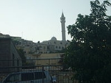
Maqam Shaykh Khalaf
Maqam Shaykh Khalaf is the only building which was noted by the antiquities authorities in the Mandate area, and it is located on a slope by the highest point in the village, set in the middle of extensive graveyards. The Maqam is a single rectangular chamber, covered by a domeDome
A dome is a structural element of architecture that resembles the hollow upper half of a sphere. Dome structures made of various materials have a long architectural lineage extending into prehistory....
. The two top courses
Course (architecture)
A course is a continuous horizontal layer of similarly-sized building material one unit high, usually in a wall. The term is almost always used in conjunction with unit masonry such as brick, cut stone, or concrete masonry units .-Styles:...
are chamfer
Chamfer
A chamfer is a beveled edge connecting two surfaces. If the surfaces are at right angles, the chamfer will typically be symmetrical at 45 degrees. A fillet is the rounding off of an interior corner. A rounding of an exterior corner is called a "round" or a "radius"."Chamfer" is a term commonly...
ed towards the dome. On the north side is a doorway, and double window set inside shallow arch
Arch
An arch is a structure that spans a space and supports a load. Arches appeared as early as the 2nd millennium BC in Mesopotamian brick architecture and their systematic use started with the Ancient Romans who were the first to apply the technique to a wide range of structures.-Technical aspects:The...
es. There is also a set of windows on the west side. Inside there are three cenotaph
Cenotaph
A cenotaph is an "empty tomb" or a monument erected in honour of a person or group of people whose remains are elsewhere. It can also be the initial tomb for a person who has since been interred elsewhere. The word derives from the Greek κενοτάφιον = kenotaphion...
s, located east-west, close to the west wall. A mihrab
Mihrab
A mihrab is semicircular niche in the wall of a mosque that indicates the qibla; that is, the direction of the Kaaba in Mecca and hence the direction that Muslims should face when praying...
is located on the south wall. The date of the building is not known, but according to A. Petersen (who inspected the place in 1994), the architecture indicate an eighteenth or early nineteenth century date.