

Antarctic oasis
Encyclopedia
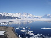
An Antarctic oasis is a large area naturally free of snow and ice in the otherwise ice-covered continent of Antarctica.
Geology
In Antarctica there are, in addition to mountain tops and nunataks, other natural snow- and ice-free areas often referred to as "Antarctic oases" or "dry valleys". These areas are surrounded by the Antarctic ice sheetAntarctic ice sheet
The Antarctic ice sheet is one of the two polar ice caps of the Earth. It covers about 98% of the Antarctic continent and is the largest single mass of ice on Earth. It covers an area of almost 14 million square km and contains 30 million cubic km of ice...
or in coastal areas situated between the ice sheet and the Antarctic ice shelves.
Antarctic oases and dry valleys develop in areas with particular regional weather patterns and geography. These areas have very low humidity and precipitation. Although these areas are very cold, sufficient solar energy is absorbed by the ground to melt what little snow does fall, or else it is scoured by katabatic winds leaving the underlying rock exposed.
Despite usually extreme aridity, some plants, in the form of bryophyte
Bryophyte
Bryophyte is a traditional name used to refer to all embryophytes that do not have true vascular tissue and are therefore called 'non-vascular plants'. Some bryophytes do have specialized tissues for the transport of water; however since these do not contain lignin, they are not considered to be...
s and lichen
Lichen
Lichens are composite organisms consisting of a symbiotic organism composed of a fungus with a photosynthetic partner , usually either a green alga or cyanobacterium...
s, can survive in Antarctic oases.
Geography
The larger oases are:- McMurdo Dry ValleysMcMurdo Dry ValleysThe McMurdo Dry Valleys are a row of snow-free valleys in Antarctica located within Victoria Land west of McMurdo Sound. The region is one of the world's most extreme deserts, and includes many interesting features including Lake Vida and the Onyx River, Antarctica's longest river.-Climate:The Dry...
, about 4900 km² (1,891.9 sq mi), Victoria LandVictoria LandVictoria Land is a region of Antarctica bounded on the east by the Ross Ice Shelf and the Ross Sea and on the west by Oates Land and Wilkes Land. It was discovered by Captain James Clark Ross in January 1841 and named after the UK's Queen Victoria... - Cape HallettCape HallettCape Hallett is a snow-free area on the northern tip of the Hallett Peninsula on the Ross Sea coast of Victoria Land, East Antarctica. A very large Adelie penguin rookery is located at Cape Hallett...
, northern Victoria LandVictoria LandVictoria Land is a region of Antarctica bounded on the east by the Ross Ice Shelf and the Ross Sea and on the west by Oates Land and Wilkes Land. It was discovered by Captain James Clark Ross in January 1841 and named after the UK's Queen Victoria... - Bunger HillsBunger HillsBunger Hills or Bunger Lakes or Bunger Oasis is a coastal range on the Knox Coast in Wilkes Land in Antarctica, consisting of a group of moderately low, rounded coastal hills, overlain by morainic drift and notably ice free throughout the year, lying south of the Highjump Archipelago.The Bunger...
, about 950 km² (366.8 sq mi), between Wilkes LandWilkes LandWilkes Land is a large district of land in eastern Antarctica, formally claimed by Australia as part of the Australian Antarctic Territory, though the validity of this claim has been placed for the period of the operation of the Antarctic Treaty, to which Australia is a signatory...
and Queen Mary Land - Holme BayHolme BayHolme Bay is a bay in Antarctica by Mac. Robertson Land, wide, containing many islands, indenting the coast north of the Framnes Mountains. Holme Bay is largely snow-free and was mapped by Norwegian cartographers from aerial photographs taken by the Lars Christensen Expedition in January-February...
, Mac. Robertson LandMac. Robertson LandMac. Robertson Land is the portion of Antarctica lying southward of the coast between William Scoresby Bay and Cape Darnley. Mac. Robertson Land is located at . In the east, Mac. Robertson Land includes the Prince Charles Mountains. Mac... - Vestfold HillsVestfold HillsVestfold Hills is an area of rounded rock coastal hills, in extent, located at the north side of Sorsdal Glacier on Ingrid Christensen Coast in Antarctica. The hills are subdivided by three west-trending peninsulas bounded by narrow fjords...
, about 420 km² (162.2 sq mi), Princess Elizabeth LandPrincess Elizabeth LandPrincess Elizabeth Land is the sector of the Australian Antarctic Territory between longitude 73° east and Cape Penck 87°43' east. Princess Elizabeth Land is located between 64°56'S and 90°00'S and between 73°35' E and 87°43'E... - Larsemann HillsLarsemann HillsLarsemann Hills are a series of low rounded snow-free coastal hills along the SE shore of Prydz Bay. The hills extend W for 9 mi from Dalk Glacier. Discovered in February 1935 by Captain Klarius Mikkelsen from the whaling ship Thorshavn, sent out by Norwegian whaling magnate Lars Christensen, and...
, Princess Elizabeth LandPrincess Elizabeth LandPrincess Elizabeth Land is the sector of the Australian Antarctic Territory between longitude 73° east and Cape Penck 87°43' east. Princess Elizabeth Land is located between 64°56'S and 90°00'S and between 73°35' E and 87°43'E... - Stillwell HillsStillwell HillsStillwell Hills is a group of largely snow-free rocky hills composed of banded gneisses and including Kemp Peak and Lealand Bluff, extending along the southwest side of William Scoresby Bay...
, about 96 km² (37.1 sq mi), Kemp LandKemp LandKemp Land is a thin sliver of Antarctica including, and lying inland from, the Kemp Coast. Part of the Australian Antarctic claim it is defined as lying between 56° 25' E and 59° 34' E, and, as with other sectors of the Antarctic, is deemed as being limited by the 60° S parallel. It is bounded in... - Schirmacher OasisSchirmacher OasisThe Schirmacher Oasis is a 25 km long and up to 3 km wide ice-free plateau with more than 100 fresh water lakes. It is situated in the Schirmacher Hills on the Princess Astrid Coast in Queen Maud Land in East Antarctica, and is on average 100 metres above sea level...
, about 34 km² (13.1 sq mi), Princess Astrid CoastPrincess Astrid CoastPrincess Astrid Coast is that portion of the coast of Queen Maud Land lying between 5° and 20° E. The entire coast is bordered by ice shelves. Discovered by Capt. H. Halvorsen of the Sevilla in March 1931 and named for Princess Astrid of Norway....
, Queen Maud LandQueen Maud LandQueen Maud Land is a c. 2.7 million-square-kilometre region of Antarctica claimed as a dependent territory by Norway. The territory lies between 20° west and 45° east, between the British Antarctic Territory to the west and the Australian Antarctic Territory to the east. The latitudinal...