
Angle Tree Stone
Encyclopedia
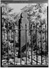
Angle Tree Stone is a historic boundary marker
astride the border of North Attleboro, Massachusetts and Plainville, Massachusetts
.
The slate marker was built in 1790 by a father and son gravestone makers. The stone was added to the National Historic Register in 1976. The stone replaced the "Angle Tree" from the 17th century, which was a surveying landmark for the boundary between Bristol and Norfolk counties, and also between North Attleborough and Plainville, Massachusetts. The county border is a straight east-west line coming from Cumberland, RI, to the site of the tree (now the stone) and then turns at an angle (hence the "angle tree" designation) and runs in a straight line from there almost to Massachusetts Bay near Cohasset.
The Angle Tree Stone has been encased in a brick and plexiglass structure since 1985 to protect it from the ravages of graffiti. It is set back 1/4 mile down a dirt road on private property.
Furthermore, in 1640, the Colonies had agreed that a line from Accord Pond, in Hingham, to Wrentham, Massachusetts, should be the dividing line between the colonies. It was an extremely important point because at that time the Grant to Massachusetts Bay extended to the Pacific Ocean. The line was surveyed by Woodward, a mathematic and Saffrey, an unknown, who made more than a few mistakes and were accused of taking too many pulls on their Toddy. The line was often the subject of disputes and not finally settled until a U.S. Supreme Court decision was handed down two centuries later in Massachusetts v. Rhode Island, 37 U.S. 12 Pet. 755 755 (1838). The line is still recognized as the border between Massachusetts, Rhode Island and Connecticut.
Boundary marker
A boundary marker, boundary stone or border stone is a robust physical marker that identifies the start of a land boundary or the change in a boundary, especially a change in a direction of a boundary...
astride the border of North Attleboro, Massachusetts and Plainville, Massachusetts
Plainville, Massachusetts
Plainville is a town in Norfolk County, Massachusetts, United States. The population as of the 2010 census was 8,264. Plainville is part of the Providence metropolitan area.- History :Plainville was originally a part of the town of Wrentham, Massachusetts...
.
The slate marker was built in 1790 by a father and son gravestone makers. The stone was added to the National Historic Register in 1976. The stone replaced the "Angle Tree" from the 17th century, which was a surveying landmark for the boundary between Bristol and Norfolk counties, and also between North Attleborough and Plainville, Massachusetts. The county border is a straight east-west line coming from Cumberland, RI, to the site of the tree (now the stone) and then turns at an angle (hence the "angle tree" designation) and runs in a straight line from there almost to Massachusetts Bay near Cohasset.
The Angle Tree Stone has been encased in a brick and plexiglass structure since 1985 to protect it from the ravages of graffiti. It is set back 1/4 mile down a dirt road on private property.
Furthermore, in 1640, the Colonies had agreed that a line from Accord Pond, in Hingham, to Wrentham, Massachusetts, should be the dividing line between the colonies. It was an extremely important point because at that time the Grant to Massachusetts Bay extended to the Pacific Ocean. The line was surveyed by Woodward, a mathematic and Saffrey, an unknown, who made more than a few mistakes and were accused of taking too many pulls on their Toddy. The line was often the subject of disputes and not finally settled until a U.S. Supreme Court decision was handed down two centuries later in Massachusetts v. Rhode Island, 37 U.S. 12 Pet. 755 755 (1838). The line is still recognized as the border between Massachusetts, Rhode Island and Connecticut.