
Amphoe Tha Sae
Encyclopedia
Tha Sae is a district (Amphoe
) in the northwestern part of
Chumphon Province
, southern Thailand
.
Tha Sae was under Mueang Chumphon, with its governor having the rank Phra. King Chulalongkorn downgraded Mueang Tha Sae to a district of Chumphon province. In 1920 the government downgraded Tha Sae to a minor district (King Amphoe) of Pathio district
. It was officially upgraded back to a full district again in 1940.
The district name originates from the public canal pier (in Thai: Tha), where plenty of Catechu Trees (Callerya atropurpurea
) are growing.
of Prachuap Khiri Khan Province
, Pathio
and Mueang Chumphon
of Chumphon Province, and Kra Buri
of Ranong Province
. To the west is the Tanintharyi Division
of Myanmar
.
The important water resources are the Tha Sae and Rap Ro rivers.
), which are further subdivided into 115 villages (muban
). Tha Sae is a township (thesaban tambon) covering parts of the tambon Tha Sea. Noen Sam Thi covers further parts of tambon Tha Sae. There are further 10 Tambon administrative organizations (TAO).
Amphoe
An amphoe is the second level administrative subdivision of Thailand. Usually translated as district, amphoe make up the provinces, and are analogous to a county seat...
) in the northwestern part of
Chumphon Province
Chumphon Province
Chumphon ) is one of the southern provinces of Thailand, at the shore of the Gulf of Thailand. Neighboring provinces are Prachuap Khiri Khan, Surat Thani and Ranong...
, southern Thailand
Thailand
Thailand , officially the Kingdom of Thailand , formerly known as Siam , is a country located at the centre of the Indochina peninsula and Southeast Asia. It is bordered to the north by Burma and Laos, to the east by Laos and Cambodia, to the south by the Gulf of Thailand and Malaysia, and to the...
.
History
MueangMueang
Mueang were historical semi-independent city-states or principalities in present-day Thailand, Laos, parts of northern Vietnam and the Shan State of Myanmar. Smaller Mueang were subordinate to more powerful neighboring Mueang, which in turn were subordinate to the central king, as described in...
Tha Sae was under Mueang Chumphon, with its governor having the rank Phra. King Chulalongkorn downgraded Mueang Tha Sae to a district of Chumphon province. In 1920 the government downgraded Tha Sae to a minor district (King Amphoe) of Pathio district
Amphoe Pathio
Pathio is a district in the northern part ofChumphon Province, southern Thailand.-Geography:Neighboring districts are Mueang Chumphon, Tha Sae of Chumphon Province and Bang Saphan Noi of Prachuap Khiri Khan Province...
. It was officially upgraded back to a full district again in 1940.
The district name originates from the public canal pier (in Thai: Tha), where plenty of Catechu Trees (Callerya atropurpurea
Callerya atropurpurea
Callerya atropurpurea is a species of tree in the family Fabaceae. It has dense, purple flowers, and seeds that are usually longer than in length...
) are growing.
Geography
Neighboring districts are (from the north clockwise) Bang Saphan NoiAmphoe Bang Saphan Noi
Bang Saphan Noi or Bangsaphan Noi is the southernmost district of Prachuap Khiri Khan Province, central Thailand.-History:The minor district Bang Saphan Noi was split off from Bang Saphan district on June 10, 1974....
of Prachuap Khiri Khan Province
Prachuap Khiri Khan Province
Prachuap Khiri Khan is one of the central provinces of Thailand. Neighboring provinces are Phetchaburi in the north and Chumphon in the south. To the west it borders Tanintharyi Division of Myanmar....
, Pathio
Amphoe Pathio
Pathio is a district in the northern part ofChumphon Province, southern Thailand.-Geography:Neighboring districts are Mueang Chumphon, Tha Sae of Chumphon Province and Bang Saphan Noi of Prachuap Khiri Khan Province...
and Mueang Chumphon
Amphoe Mueang Chumphon
Mueang Chumphon is the capital district of Chumphon Province, southern Thailand.-Geography:Neighboring districts are Sawi of Chumphon Province, Kra Buri of Ranong Province, Tha Sae and Pathio of Chumphon Province again.-Administration:The district is subdivided into 17 subdistricts , which are...
of Chumphon Province, and Kra Buri
Amphoe Kra Buri
Kra Buri is the northernmost district of Ranong Province, southern Thailand.-History:Mueang Tra was established in Ayutthaya era as the 4th class city under Chumphon. The first governor was Mr. Kaew, a cousin of the governor of Nakhon Si Thammarat. Later he was promoted to be Phra Kaew Korop ....
of Ranong Province
Ranong Province
Ranong is one of the southern provinces of Thailand, on the coast of the Andaman Sea. It is the province with the fewest citizens. Neighboring provinces are Chumphon, Surat Thani and Phang Nga...
. To the west is the Tanintharyi Division
Tanintharyi Division
Tanintharyi Region , is an administrative region of Myanmar, covering the long narrow southern part of the country on the Kra Isthmus. It borders with the Andaman Sea to the west and with the Tenasserim Hills, beyond which lies Thailand, to the east. To the north is the Mon State. The capital of...
of Myanmar
Myanmar
Burma , officially the Republic of the Union of Myanmar , is a country in Southeast Asia. Burma is bordered by China on the northeast, Laos on the east, Thailand on the southeast, Bangladesh on the west, India on the northwest, the Bay of Bengal to the southwest, and the Andaman Sea on the south....
.
The important water resources are the Tha Sae and Rap Ro rivers.
Administration
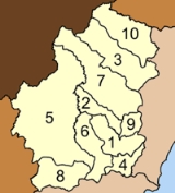
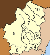
The district is subdivided into 10 subdistricts (tambonTambon
Tambon is a local government unit in Thailand. Below district and province , they form the third administrative subdivision level. As of the 2009 there are 7255 tambon, not including the 169 khwaeng of Bangkok, which are set at the same administrative level, thus every district contains 8-10 tambon...
), which are further subdivided into 115 villages (muban
Muban
Muban is the lowest administrative subdivision of Thailand. Usually translated as village, they are the subdivision of tambon. As of 2008, there are 74944 administrative villages in Thailand. As of the 1990 census, the average village consisted of 144 households or 746 persons.A muban does not...
). Tha Sae is a township (thesaban tambon) covering parts of the tambon Tha Sea. Noen Sam Thi covers further parts of tambon Tha Sae. There are further 10 Tambon administrative organizations (TAO).
|
 |