
Amphoe Phra Pradaeng
Encyclopedia
Phra Pradaeng is a district (Amphoe
) of Samut Prakan Province
in Thailand
.
, Rat Burana
, Yan Nawa
, Khlong Toei
, Phra Khanong
and Bang Na
(all Bangkok
), and the districts Mueang Samut Prakan
and Phra Samut Chedi
of Samut Prakan.
It is located a big bend on the Chao Phraya river.
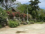
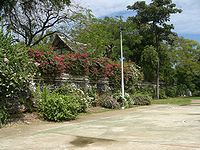
built the Pom Phlaeng Faifa fort at the river bend. The fort is now located in a small park and accessible for visitors.
In 1819 the new town Samut Prakan
(or Paknam) was established. Due to the economic problems in the early 1930s several administrative entities were abolished, including Phra Phradaeng province which had its districts were assigned to Samut Prakan and Thonburi effective April 1 1932.
A 2 km tramway across the neck of the huge Phra Pradaeng river bend opened in 1908 and closed c.1940. Operated by a private company, the motorised trams connected with motorboat services to Bangkok and to Paknam at each end of the line. The tram cut a considerable time off the up and downriver journey by avoiding the long river bend.
), which are further subdivided into 67 villages (muban
). The town (thesaban mueang) Phra Phradaeng covers the whole tambon Talad, the town Lat Luang the tambon Bang Phueng, Bang Chak and Bang Kharu. The township (thesaban tambon) Samrong Thai covers the tambon Samrong Tai, Samrong, Samron Klang, Bang Hua Suea and Bang Ya Phraek. There are further 6 Tambon administrative organizations (TAO) for the tambon not covered by the municipalities.
Amphoe
An amphoe is the second level administrative subdivision of Thailand. Usually translated as district, amphoe make up the provinces, and are analogous to a county seat...
) of Samut Prakan Province
Samut Prakan Province
Samut Prakan is one of the central provinces of Thailand. It is part of the Bangkok Metropolitan Region. Neighboring provinces are Bangkok, to the north and west, and Chachoengsao to the east....
in Thailand
Thailand
Thailand , officially the Kingdom of Thailand , formerly known as Siam , is a country located at the centre of the Indochina peninsula and Southeast Asia. It is bordered to the north by Burma and Laos, to the east by Laos and Cambodia, to the south by the Gulf of Thailand and Malaysia, and to the...
.
Geography
Neighboring districts are (from the west clockwise) Thung KhruThung Khru
Thung Khru is one of the 50 districts of Bangkok, Thailand. The district is bounded by Rat Burana district of Bangkok, Amphoe Phra Pradaeng and Amphoe Phra Samut Chedi of Samut Prakan Province, Bang Khun Thian and Chom Thong of Bangkok.-History:Thung Khru was split off from Rat Burana, announced...
, Rat Burana
Rat Burana
Rat Burana is one of the 50 districts of Bangkok, Thailand. The district is bounded by Amphoe Phra Pradaeng of Samut Prakan Province, Thung Khru, Chom Thong and Thon Buri districts of Bangkok while its north to east is Chao Phraya River with Bang Kho Laem and Yan Nawa districts across the...
, Yan Nawa
Yan Nawa
Yan Nawa or Yannawa is one of the 50 districts of Bangkok, Thailand. The district is bounded by Rat Burana , Bang Kho Laem, Sathon and Khlong Toei districts of Bangkok while its remaining neighbor from east to south is Amphoe Phra Pradaeng of Samut Prakan Province.-History:Yan Nawa, in the past,...
, Khlong Toei
Khlong Toei
Khlong Toei is a district in central Bangkok, long known for its slum. It is bordered by the Chao Phraya River and contains major port facilities. It is also the name of a major market, though not touristic...
, Phra Khanong
Phra Khanong
Phra Khanong is one of the 50 districts of Bangkok, Thailand. Its neighbor, clockwise from north, are Suan Luang, Prawet, and Bang Na districts of Bangkok, Amphoe Phra Pradaeng of Samut Prakan Province , Khlong Toei and Watthana of Bangkok.-History:Phra Khanong was an amphoe of Nakhon Khuan Khan...
and Bang Na
Bang Na
Bang Na is one of the fifty districts of Bangkok, Thailand. Its neighbors, clockwise from the north, are the Phra Khanong and Prawet districts of Bangkok, Amphoe Bang Phli, Amphoe Mueang, and Amphoe Phra Pradaeng of Samut Prakan Province.-History:...
(all Bangkok
Bangkok
Bangkok is the capital and largest urban area city in Thailand. It is known in Thai as Krung Thep Maha Nakhon or simply Krung Thep , meaning "city of angels." The full name of Bangkok is Krung Thep Mahanakhon Amon Rattanakosin Mahintharayutthaya Mahadilok Phop Noppharat Ratchathani Burirom...
), and the districts Mueang Samut Prakan
Amphoe Mueang Samut Prakan
Mueang Samut Prakan is the capital district of Samut Prakan Province, central Thailand. The district has the highest population of all districts of Thailand.-Tourist attractions:...
and Phra Samut Chedi
Amphoe Phra Samut Chedi
Phra Samut Chedi is the westernmost district of Samut Prakan Province in central Thailand.-Geography:Neighboring districts are Bang Khun Thian and Thung Khru of Bangkok, Phra Pradaeng and Mueang Samut Prakan of Samut Prakan province.-Sights:The district is named after the temple Phra Samut...
of Samut Prakan.
It is located a big bend on the Chao Phraya river.
History
Phra Pradeang was the original center of the area south of Bangkok near the mouth of the Chao Phraya river. Originally named Nakhon Khuan Khan (นครเขื่อนขันธ์) it was settled by Mon. In 1815, King Rama IIBuddha Loetla Nabhalai
Phra Bat Somdet Phra Poramenthramaha Isarasundhorn Phra Buddha Loetla Nabhalai , or Rama II , was the second monarch of Siam under the House of Chakri, ruling from 1809-1824. In 1809, Isarasundhorn succeeded his father Buddha Yodfa Chulaloke, the founder of Chakri dynasty, as Buddha Loetla Nabhalai...
built the Pom Phlaeng Faifa fort at the river bend. The fort is now located in a small park and accessible for visitors.

In 1819 the new town Samut Prakan
Amphoe Mueang Samut Prakan
Mueang Samut Prakan is the capital district of Samut Prakan Province, central Thailand. The district has the highest population of all districts of Thailand.-Tourist attractions:...
(or Paknam) was established. Due to the economic problems in the early 1930s several administrative entities were abolished, including Phra Phradaeng province which had its districts were assigned to Samut Prakan and Thonburi effective April 1 1932.
A 2 km tramway across the neck of the huge Phra Pradaeng river bend opened in 1908 and closed c.1940. Operated by a private company, the motorised trams connected with motorboat services to Bangkok and to Paknam at each end of the line. The tram cut a considerable time off the up and downriver journey by avoiding the long river bend.
Administration
The district is subdivided into 15 subdistricts (tambonTambon
Tambon is a local government unit in Thailand. Below district and province , they form the third administrative subdivision level. As of the 2009 there are 7255 tambon, not including the 169 khwaeng of Bangkok, which are set at the same administrative level, thus every district contains 8-10 tambon...
), which are further subdivided into 67 villages (muban
Muban
Muban is the lowest administrative subdivision of Thailand. Usually translated as village, they are the subdivision of tambon. As of 2008, there are 74944 administrative villages in Thailand. As of the 1990 census, the average village consisted of 144 households or 746 persons.A muban does not...
). The town (thesaban mueang) Phra Phradaeng covers the whole tambon Talad, the town Lat Luang the tambon Bang Phueng, Bang Chak and Bang Kharu. The township (thesaban tambon) Samrong Thai covers the tambon Samrong Tai, Samrong, Samron Klang, Bang Hua Suea and Bang Ya Phraek. There are further 6 Tambon administrative organizations (TAO) for the tambon not covered by the municipalities.
| No. | Name | Thai name | Villages | Inh. Population A population is all the organisms that both belong to the same group or species and live in the same geographical area. The area that is used to define a sexual population is such that inter-breeding is possible between any pair within the area and more probable than cross-breeding with individuals... |
|
|---|---|---|---|---|---|
| 1. | Talat | ตลาด | |||
| 11,864 | |||||
| 2. | Bang Phueng | บางพึ่ง | |||
| 26,420 | |||||
| 3. | Bang Chak | บางจาก | |||
| 22,079 | |||||
| 4. | Bang Khru | บางครุ | |||
| 27,311 | |||||
| 5. | Bang Ya Phraek | บางหญ้าแพรก | |||
| 24,506 | |||||
| 6. | Bang Hua Suea | บางหัวเสือ | |||
| 11,367 | |||||
| 7. | Samrong Tai | สำโรงใต้ | |||
| 14,850 | |||||
| 8. | Bang Yo | บางยอ | 10 | 10,860 | |
| 9. | Bang Kachao | บางกะเจ้า | 9 | 5,342 | |
| 10. | Bang Nam Phueng | บางน้ำผึ้ง | 11 | 4,636 | |
| 11. | Bang Krasop | บางกระสอบ | 11 | 2,402 | |
| 12. | Bang Ko Bua | บางกอบัว | 13 | 7,184 | |
| 13. | Song Khanong | ทรงคนอง | 13 | 8,505 | |
| 14. | Samrong | สำโรง | |||
| 15,936 | |||||
| 15. | Samrong Klang | สำโรงกลาง | |||
| 13,879 |
External links
- http://www.phrapradaeng.org (Thai only)