
Amphoe Lam Sonthi
Encyclopedia
Lam Sonthi is the easternmost district (Amphoe
) of Lopburi Province
, central Thailand.
. It was upgraded to a full Amphoe on December 5, 1996. The sixth tambon Khao Noi was created in 1994.
that originates in the Sap Langka Wildlife Sanctuary, the last forest of Lopburi, located in Tambon Kud Ta Phet in the very north of the district.
Neighboring districts are (from the north clockwise) Si Thep
and Wichian Buri
of Phetchabun Province
, Thep Sathit
of Chaiyaphum Province
, Thepharak, Dan Khun Thot
and Sikhio
of Nakhon Ratchasima Province
, Muak Lek of Saraburi Province
, and Tha Luang
and Chai Badan
of Lopburi Province.
To the east the district boundary is formed by the Phang Hoei ridge, while the boundary in the northwest is formed by the Luak ridge, both ridges part of the Phetchabun mountain range
.
), which are further subdivided into 48 villages (muban
). There are no municipal (thesaban
) areas, and further 4 Tambon administrative organizations (TAO).
Amphoe
An amphoe is the second level administrative subdivision of Thailand. Usually translated as district, amphoe make up the provinces, and are analogous to a county seat...
) of Lopburi Province
Lopburi Province
Lop Buri is one of the central provinces of Thailand. Neighboring provinces are Phetchabun, Chaiyaphum, Nakhon Ratchasima, Saraburi, Phra Nakhon Si Ayutthaya, Ang Thong, Sing Buri and Nakhon Sawan.-Geography:...
, central Thailand.
History
Lam Sonthi was created as a minor district (King Amphoe) on April 1 1989, by splitting off five tambon from the district Chai BadanAmphoe Chai Badan
Chai Badan is a district in eastern part of Lopburi Province, central Thailand. The local people usually call it Lam Narai, as the district center is located in Tambon Lam Narai.-History:...
. It was upgraded to a full Amphoe on December 5, 1996. The sixth tambon Khao Noi was created in 1994.
Geography
The name Lam Sonthi comes from the small Sonthi RiverSonthi River
The Sonthi River is a tributary of the Pa Sak River. It originates at the Ruak and Phanghoei mountains in the border area of Lam Sonthi district, Lopburi province and Si Thep, Phetchabun province. The river flows southward as the backbone of Lam Sonthi district and joins with the Phaya Klang River...
that originates in the Sap Langka Wildlife Sanctuary, the last forest of Lopburi, located in Tambon Kud Ta Phet in the very north of the district.
Neighboring districts are (from the north clockwise) Si Thep
Amphoe Si Thep
Si Thep is the southernmost district of Phetchabun Province, located in the Pa Sak valley.-History:The district was created on December 13 1970 as a minor district with territory from Wichian Buri district. It was upgraded to be Amphoe Si Thep on August 8, 1976.The ancient city of Si Thep was...
and Wichian Buri
Amphoe Wichian Buri
Wichian Buri is a district in southern part of Phetchabun Province, northern Thailand.-History:In the past the area of Wichian Buri was administrated by the Mueang Tha Rong. King Rama III upgraded status of Tha Rong city by gathering Bua Chum and Chai Badan and changed the city name to be Wichian...
of Phetchabun Province
Phetchabun Province
Phetchabun is one of the northern provinces of Thailand. Neighboring provinces are Loei, Khon Kaen, Chaiyaphum, Lopburi, Nakhon Sawan, Phichit and Phitsanulok.- Geography :...
, Thep Sathit
Amphoe Thep Sathit
Thep Sathit is a district in the southwestern part of Chaiyaphum Province, eastern Thailand.-History:In the past time, it was just a small community of ancient Mon people....
of Chaiyaphum Province
Chaiyaphum Province
Chaiyaphum is one of the north-eastern provinces of Thailand. Neighboring provinces are Khon Kaen, Nakhon Ratchasima, Lopburi and Phetchabun.- Etymology :...
, Thepharak, Dan Khun Thot
Amphoe Dan Khun Thot
Dan Khun Thot is a district in western part of Nakhon Ratchasima Province, Thailand.-History:The town Dan Khun Thot was built before the reign of King Taksin. It became an Amphoe in 1908. At the same time, the center of the town was moved from Wat Pho Chumphon to the western side of the Ban Han...
and Sikhio
Amphoe Sikhio
Sikhio is a district in the western part of Nakhon Ratchasima Province, Thailand.-History:Originally known as Mueang Nakhon Chantuek, Sikhio is an ancient frontier city between the Thai dominated Chao Phraya valley and the Lao dominated Khorat Plateau. There is not record of the time of its...
of Nakhon Ratchasima Province
Nakhon Ratchasima Province
Nakhon Ratchasima or , often shortened to Korat or Khorat , is one of the north-eastern provinces of Thailand...
, Muak Lek of Saraburi Province
Saraburi Province
Saraburi is one of the central provinces of Thailand. Neighboring provinces are Lopburi, Nakhon Ratchasima, Nakhon Nayok, Pathum Thani and Ayutthaya. Saraburi has been an important town since ancient times...
, and Tha Luang
Amphoe Tha Luang
Tha Luang is a district in eastern part of Lopburi Province, central Thailand.-History:The minor district was created on November 15 1978, when the four tambon Tha Luang, Sab Champha, Nong Phak Waen and Kaeng Phak Kut were split off from Chai Badan...
and Chai Badan
Amphoe Chai Badan
Chai Badan is a district in eastern part of Lopburi Province, central Thailand. The local people usually call it Lam Narai, as the district center is located in Tambon Lam Narai.-History:...
of Lopburi Province.
To the east the district boundary is formed by the Phang Hoei ridge, while the boundary in the northwest is formed by the Luak ridge, both ridges part of the Phetchabun mountain range
Phetchabun Mountains
The Phetchabun mountains are a mountain range in Thailand.-Geography:It extends in a roughly north-south direction, and separates the broad Chao Phraya river valley of central Thailand from the Khorat Plateau of northeast Thailand...
.
Administration
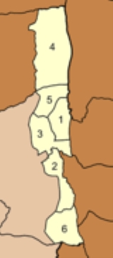
The district is subdivided into 6 subdistricts (tambonTambon
Tambon is a local government unit in Thailand. Below district and province , they form the third administrative subdivision level. As of the 2009 there are 7255 tambon, not including the 169 khwaeng of Bangkok, which are set at the same administrative level, thus every district contains 8-10 tambon...
), which are further subdivided into 48 villages (muban
Muban
Muban is the lowest administrative subdivision of Thailand. Usually translated as village, they are the subdivision of tambon. As of 2008, there are 74944 administrative villages in Thailand. As of the 1990 census, the average village consisted of 144 households or 746 persons.A muban does not...
). There are no municipal (thesaban
Thesaban
Thesaban are the municipalities in Thailand. There are three levels of municipalities - city, town and subdistrict municipality. Both Bangkok and Pattaya are special municipal entities outside the thesaban system....
) areas, and further 4 Tambon administrative organizations (TAO).
|
 |