
Amphoe Huai Yot
Encyclopedia
Huai Yot is a district (Amphoe
) in the northern part of Trang Province
, Thailand
.
of Trang Province, Thung Song
of Nakhon Si Thammarat Province
, Pa Phayom
, Si Banphot
of Phatthalung Province
, Mueang Trang
, Wang Wiset
of Trang Province again and Bang Khan
of Nakhon Si Thammarat Province
again.
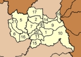
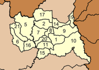
), which are further subdivided into 133 villages (muban
). There are three townships (thesaban tambon) - Huai Yot covers parts of tambon Huai Yot and Khao Pun; Na Wong covers parts of tambon Na Wong, Bang Kung and Wang Khiri; and Lam Phu Ra covers parts of tambon Lam Phu Ra. There are further 16 Tambon administrative organizations (TAO).
Missing numbers are tambon which now form Ratsada district.
Amphoe
An amphoe is the second level administrative subdivision of Thailand. Usually translated as district, amphoe make up the provinces, and are analogous to a county seat...
) in the northern part of Trang Province
Trang Province
Trang is one of the southern provinces of Thailand, at the western shore of the Malay Peninsula to the Andaman Sea. Neighboring provinces are Krabi, Nakhon Si Thammarat, Phatthalung and Satun....
, Thailand
Thailand
Thailand , officially the Kingdom of Thailand , formerly known as Siam , is a country located at the centre of the Indochina peninsula and Southeast Asia. It is bordered to the north by Burma and Laos, to the east by Laos and Cambodia, to the south by the Gulf of Thailand and Malaysia, and to the...
.
Geography
Neighboring districts are (from the north clockwise) RatsadaAmphoe Ratsada
Ratsada is a district in the northeastern part of Trang Province, Thailand.- History :The minor district Ratsada was established on April 1 1991 by splitting off five tambon from Huai Yot district...
of Trang Province, Thung Song
Amphoe Thung Song
Thung Song is a district in the southwestern part of Nakhon Si Thammarat Province, southern Thailand.-Geography:Neighboring districts are Bang Khan, Thung Yai, Na Bon, Chang Klang, Lan Saka, Ron Phibun, Chulabhorn, Cha-uat of Nakhon Si Thammarat Province, Huai Yot and Ratsada of Trang...
of Nakhon Si Thammarat Province
Nakhon Si Thammarat Province
Nakhon Si Thammarat is one of the southern provinces of Thailand, at the eastern shore of the Gulf of Thailand...
, Pa Phayom
Amphoe Pa Phayom
Pa Phayom is the northernmost district of Phatthalung Province, southern Thailand.-Geography:Neighboring districts are Khuan Khanun, Si Banphot of Phattalung Province, Huai Yot of Trang Province and Cha-uat of Nakhon Si Thammarat Province.-History:The minor district was established on January...
, Si Banphot
Amphoe Si Banphot
Si Banphot is a district of Phatthalung Province, southern Thailand. It may also be spelled Sri Banphot.-Geography:Neighboring districts are Pa Phayom, Khuan Khanun and Srinagarindra of Phatthalung Province, Na Yong, Mueang Trang and Huai Yot of Trang Province.-History:The minor district was...
of Phatthalung Province
Phatthalung Province
Phatthalung is one of the southern provinces of Thailand. Neighboring provinces are Nakhon Si Thammarat, Songkhla, Satun and Trang.-Geography:...
, Mueang Trang
Amphoe Mueang Trang
Mueang Trang Mueang Trang Mueang Trang ( , also Mueang Thap Thiang ( ) is the capital district ( Amphoe Mueang ) of Trang Province, Thailand. The city (thesaban nakhon) has a population of 59,637 (2005) and covers the whole tambon Thap Thiang of Mueang Trang district....
, Wang Wiset
Amphoe Wang Wiset
-History:The minor district Wang Wiset was established on July 15 1981 by splitting off five tambon from Sikao district. The first temporary district office within the temple Rat Rangsan was opened on November 2 1981.It was upgraded to a full district on May 21 1990.-Geography:Neighboring...
of Trang Province again and Bang Khan
Amphoe Bang Khan
Bang Khan is a district of Nakhon Si Thammarat Province, southern Thailand.-Geography:Neighboring districts are Thung Yai and Thung Song of Nakhon Si Thammarat, Ratsada, Huai Yot and Wang Wiset of Trang Province, and Lam Thap of Krabi Province.-History:The district was created as a minor...
of Nakhon Si Thammarat Province
Nakhon Si Thammarat Province
Nakhon Si Thammarat is one of the southern provinces of Thailand, at the eastern shore of the Gulf of Thailand...
again.
Administration
The district is subdivided into 16 subdistricts (tambonTambon
Tambon is a local government unit in Thailand. Below district and province , they form the third administrative subdivision level. As of the 2009 there are 7255 tambon, not including the 169 khwaeng of Bangkok, which are set at the same administrative level, thus every district contains 8-10 tambon...
), which are further subdivided into 133 villages (muban
Muban
Muban is the lowest administrative subdivision of Thailand. Usually translated as village, they are the subdivision of tambon. As of 2008, there are 74944 administrative villages in Thailand. As of the 1990 census, the average village consisted of 144 households or 746 persons.A muban does not...
). There are three townships (thesaban tambon) - Huai Yot covers parts of tambon Huai Yot and Khao Pun; Na Wong covers parts of tambon Na Wong, Bang Kung and Wang Khiri; and Lam Phu Ra covers parts of tambon Lam Phu Ra. There are further 16 Tambon administrative organizations (TAO).
|
 |
Missing numbers are tambon which now form Ratsada district.