
Amphoe Hat Samran
Encyclopedia
Hat Samran is a district (Amphoe
) in the southern part of Trang Province
, Thailand
.
.
Following a decision of the Thai government on May 15, 2007, all of the 81 minor districts were to be upgraded to full districts. With the publishing in the Royal Gazette on August 24 the upgrade became official
.
, to the north Kantang district
. To the west and south is the Andaman Sea
.
), which are further subdivided into 21 villages (muban
). There are no municipal (thesaban
) areas, and 3 Tambon administrative organizations (TAO).
Amphoe
An amphoe is the second level administrative subdivision of Thailand. Usually translated as district, amphoe make up the provinces, and are analogous to a county seat...
) in the southern part of Trang Province
Trang Province
Trang is one of the southern provinces of Thailand, at the western shore of the Malay Peninsula to the Andaman Sea. Neighboring provinces are Krabi, Nakhon Si Thammarat, Phatthalung and Satun....
, Thailand
Thailand
Thailand , officially the Kingdom of Thailand , formerly known as Siam , is a country located at the centre of the Indochina peninsula and Southeast Asia. It is bordered to the north by Burma and Laos, to the east by Laos and Cambodia, to the south by the Gulf of Thailand and Malaysia, and to the...
.
History
The minor district (King Amphoe) Hat Samran was established on April 30, 1994 by splitting it from Palian districtAmphoe Palian
Palian is a district in the southern part of Trang Province, Thailand.-Geography:Neighboring districts are Kong Ra, Tamot and Pa Bon of Phatthalung Province, Khuan Kalong, Manang and Thung Wa of Satun Province, Hat Samran and Yan Ta Khao of Trang Province.-Administration:The district is...
.
Following a decision of the Thai government on May 15, 2007, all of the 81 minor districts were to be upgraded to full districts. With the publishing in the Royal Gazette on August 24 the upgrade became official
.
Geography
To the east is Palian districtAmphoe Palian
Palian is a district in the southern part of Trang Province, Thailand.-Geography:Neighboring districts are Kong Ra, Tamot and Pa Bon of Phatthalung Province, Khuan Kalong, Manang and Thung Wa of Satun Province, Hat Samran and Yan Ta Khao of Trang Province.-Administration:The district is...
, to the north Kantang district
Amphoe Kantang
Kantang is a district in the western part of Trang Province, Thailand.-History:Kantang was the original capital of Trang Province, at first in Khuan Thani, and then from 1893-1916 to the coastal Kantang itself. As the area was prone to floodings the capital was finally moved further inland to...
. To the west and south is the Andaman Sea
Andaman Sea
The Andaman Sea or Burma Sea is a body of water to the southeast of the Bay of Bengal, south of Burma, west of Thailand and east of the Andaman Islands, India; it is part of the Indian Ocean....
.
Administration
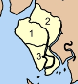
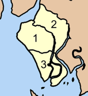
The district is subdivided into 3 subdistricts (tambonTambon
Tambon is a local government unit in Thailand. Below district and province , they form the third administrative subdivision level. As of the 2009 there are 7255 tambon, not including the 169 khwaeng of Bangkok, which are set at the same administrative level, thus every district contains 8-10 tambon...
), which are further subdivided into 21 villages (muban
Muban
Muban is the lowest administrative subdivision of Thailand. Usually translated as village, they are the subdivision of tambon. As of 2008, there are 74944 administrative villages in Thailand. As of the 1990 census, the average village consisted of 144 households or 746 persons.A muban does not...
). There are no municipal (thesaban
Thesaban
Thesaban are the municipalities in Thailand. There are three levels of municipalities - city, town and subdistrict municipality. Both Bangkok and Pattaya are special municipal entities outside the thesaban system....
) areas, and 3 Tambon administrative organizations (TAO).
|
 |