
Altofts railway station
Encyclopedia
Altofts
Altofts is a village near Normanton, West Yorkshire, England. The village is usually quiet, having a mixed population of young and old. There are four pubs, two Working Men's Clubs, a handful of small shops, one post office and a few farms. Lower Altofts is the area at the lower end of the village...
near Normanton
Normanton, West Yorkshire
Normanton is a town and civil parish within the City of Wakefield in West Yorkshire, England. It is northeast of Wakefield and southwest of Castleford, and at the time of the 2001 Census, the population was 19,949.-History:...
in the English
England
England is a country that is part of the United Kingdom. It shares land borders with Scotland to the north and Wales to the west; the Irish Sea is to the north west, the Celtic Sea to the south west, with the North Sea to the east and the English Channel to the south separating it from continental...
county of West Yorkshire
West Yorkshire
West Yorkshire is a metropolitan county within the Yorkshire and the Humber region of England with a population of 2.2 million. West Yorkshire came into existence as a metropolitan county in 1974 after the passage of the Local Government Act 1972....
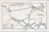
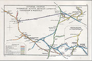
. It was opened in 1870 as Altofts and Whitwood by the Midland Railway
Midland Railway
The Midland Railway was a railway company in the United Kingdom from 1844 to 1922, when it became part of the London, Midland and Scottish Railway....
on its line from Derby to Leeds Wellington Station. Much of the village of Altofts is in fact closer to Normanton station
It was built on an embankment using spoil from the cutting south of Normanton
Normanton railway station
Normanton railway station serves the town of Normanton in West Yorkshire, England. It lies south-east of Leeds railway station on the Hallam Line, which is operated by Northern Rail.-History:...
. The area was in any case, prone to subsidence, resulting in speed restrictions and the need to shore up the platforms.
North of the station the line crosses the Aire and Calder Navigation
Aire and Calder Navigation
The Aire and Calder Navigation is a river and canal system of the River Aire and the River Calder in the metropolitan county of West Yorkshire, England. The first improvements to the rivers above Knottingley were completed in 1704 when the Aire was made navigable to Leeds and the Calder to...
and the River Calder
River Calder, West Yorkshire
The River Calder is a river in West Yorkshire, in Northern England.The Calder rises on the green eastern slopes of the Pennines flows through alternating green countryside, former woollen-mill villages, and large and small towns before joining the River Aire near Castleford.The river's valley is...
by means of a viaduct of five sixty foot arches.
History
Opened by the Midland RailwayMidland Railway
The Midland Railway was a railway company in the United Kingdom from 1844 to 1922, when it became part of the London, Midland and Scottish Railway....
on 1 September 1870, and originally named Altofts and Whitwood, it became part of the London, Midland and Scottish Railway
London, Midland and Scottish Railway
The London Midland and Scottish Railway was a British railway company. It was formed on 1 January 1923 under the Railways Act of 1921, which required the grouping of over 120 separate railway companies into just four...
during the Grouping
Railways Act 1921
The Railways Act 1921, also known as the Grouping Act, was an enactment by the British government of David Lloyd George intended to stem the losses being made by many of the country's 120 railway companies, move the railways away from internal competition, and to retain some of the benefits which...
of 1923. The line then passed on to the Eastern Region of British Railways
Eastern Region of British Railways
The Eastern Region was a region of British Railways from 1948. The region ceased to be an operating unit in its own right in the 1980s and was wound up at the end of 1992...
on nationalisation in 1948.
When Sectorisation
British Rail brand names
British Rail was the brand image of the nationalised railway owner and operator in Great Britain, the British Railways Board, used from 1965 until its breakup and sell-off from 1993 onwards....
was introduced in the 1980s, the station was served by Regional Railways
Regional Railways
Regional Railways was one of the three passenger sectors of British Rail created in 1982 that existed until 1996, 3 years after privatisation. The sector was originally called Provincial....
under arrangements with the WYPTE METRO
West Yorkshire Passenger Transport Executive
The West Yorkshire Passenger Transport Executive is the Passenger Transport Executive for the county of West Yorkshire, England. It is the executive arm of the West Yorkshire Integrated Transport Authority and was originally formed on 1 April 1974 as the West Yorkshire Passenger Transport...
.
The name was simplified to Altofts on 4 May 1970 and the station closed on 14 May 1990, the last day of service being 12 May 1990.
Faster services on the Hallam line
Hallam Line
The Hallam Line is the name given to rail services operated by Northern Rail, in the West Yorkshire Metro/ Travel South Yorkshire area of northern England which connect Leeds and Sheffield via Barnsley. It is the slower of the two routes between Leeds and Sheffield, with faster services provided...
currently run past the former station on their way from Normanton to Woodlesford. Slower trains since 1988 instead follow an alternative route along the former North Eastern Railway
North Eastern Railway (UK)
The North Eastern Railway , was an English railway company. It was incorporated in 1854, when four existing companies were combined, and was absorbed into the London and North Eastern Railway at the Grouping in 1923...
lines from Normanton to Castleford
Castleford railway station
Castleford railway station is an unstaffed railway station serving the town of Castleford in West Yorkshire. It lies on the Hallam and the Pontefract Lines south east of Leeds....
, where they have to reverse direction, rather than the direct line through Altofts.