Alfredton, Victoria
Encyclopedia
Alfredton is a rural-urban fringe suburb west of Ballarat
, Victoria, Australia
. The population at the 2006 census was 5,796 making it the fourth most populated in the Ballarat urban area.
Alfredton is located west of Lake Wendouree
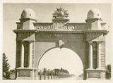
along Sturt Street. The suburb has some of Ballarat's best known landmarks including the Arch of Victory, a World War I memorial which once marked the entrance to Ballarat and the start of Ballarat's Avenue of Honour
, the longest war memorial roadside plantation in Australia, which extends 18 km to the Western Freeway
.
The Alfredton area is central to Western Ballarat's growth corridor, an area where suburban development
is encouraged by the City of Ballarat
and State Government of Victoria. Most of urban Ballarat's subdivision
for new housing estates is happening in Greenfield land
to the south, north and west of the Avenue of Honour. Large estates include The Chase and Insignia.
, the majority of Alfredton's residential areas have been developed under the concepts of street hierarchy
with looped streets and cul-de-sac
s and almost all single-family detached homes. As a result while the suburban streets are quiet the main roads around Alfredton are particularly busy.
There is a bus service which runs regularly to the city.
A long disused freight railway loop bisects the suburb. The nearest railway station is Wendouree 3 km to the north.
Ballarat, Victoria
Ballarat is a city in the state of Victoria, Australia, approximately west-north-west of the state capital Melbourne situated on the lower plains of the Great Dividing Range and the Yarrowee River catchment. It is the largest inland centre and third most populous city in the state and the fifth...
, Victoria, Australia
Australia
Australia , officially the Commonwealth of Australia, is a country in the Southern Hemisphere comprising the mainland of the Australian continent, the island of Tasmania, and numerous smaller islands in the Indian and Pacific Oceans. It is the world's sixth-largest country by total area...
. The population at the 2006 census was 5,796 making it the fourth most populated in the Ballarat urban area.
Alfredton is located west of Lake Wendouree
Lake Wendouree
Lake Wendouree is an artificially-created and maintained shallow urban lake located in the suburb of the same name in the city of Ballarat, Victoria, Australia...
along Sturt Street. The suburb has some of Ballarat's best known landmarks including the Arch of Victory, a World War I memorial which once marked the entrance to Ballarat and the start of Ballarat's Avenue of Honour
Avenue of honour
Avenue of Honour is the term given to a memorial avenue of trees, with each tree symbolising a person.The tradition, which originated in the Goldfields region of Victoria, Australia is an important part of Australian culture....
, the longest war memorial roadside plantation in Australia, which extends 18 km to the Western Freeway
Western Freeway (Victoria)
The Western Freeway is a 125 kilometre Australian freeway linking the state capital of Victoria to the major regional city of Ballarat...
.
The Alfredton area is central to Western Ballarat's growth corridor, an area where suburban development
Urban sprawl
Urban sprawl, also known as suburban sprawl, is a multifaceted concept, which includes the spreading outwards of a city and its suburbs to its outskirts to low-density and auto-dependent development on rural land, high segregation of uses Urban sprawl, also known as suburban sprawl, is a...
is encouraged by the City of Ballarat
City of Ballarat
The City of Ballarat is a Local Government Area in Victoria, Australia around Ballarat. It is located in the western part of the state. It has an area of 740 square kilometres. In 2001 it had a population of 81,000...
and State Government of Victoria. Most of urban Ballarat's subdivision
Subdivision (land)
Subdivision is the act of dividing land into pieces that are easier to sell or otherwise develop, usually via a plat. The former single piece as a whole is then known in the United States as a subdivision...
for new housing estates is happening in Greenfield land
Greenfield land
Greenfield land is a term used to describe undeveloped land in a city or rural area either used for agriculture, landscape design, or left to naturally evolve...
to the south, north and west of the Avenue of Honour. Large estates include The Chase and Insignia.
Urban form and housing
While a small section of the original township and main roads are grid planGrid plan
The grid plan, grid street plan or gridiron plan is a type of city plan in which streets run at right angles to each other, forming a grid...
, the majority of Alfredton's residential areas have been developed under the concepts of street hierarchy
Street hierarchy
The street hierarchy is an urban design technique for laying out road networks that exclude automobile through-traffic from developed areas. It is conceived as a hierarchy of roads that embeds the link importance of each road type in the network topology...
with looped streets and cul-de-sac
Cul-de-sac
A cul-de-sac is a word of French origin referring to a dead end, close, no through road or court meaning dead-end street with only one inlet/outlet...
s and almost all single-family detached homes. As a result while the suburban streets are quiet the main roads around Alfredton are particularly busy.
Transport
The main form of transport in Alfredton is the private motor car and Alfredton can be classed as a car dependent suburb. The suburb is serviced by Ballarat taxis.There is a bus service which runs regularly to the city.
A long disused freight railway loop bisects the suburb. The nearest railway station is Wendouree 3 km to the north.

