
Aletsch Glacier
Encyclopedia
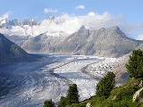
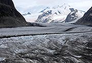
The Aletsch Glacier or Great Aletsch Glacier (German: Grosser Aletschgletscher) is the largest glacier
in the Alps
. It has a length of about 23 km (14.3 mi) and covers more than 120 square kilometres (46.3 sq mi) in the eastern Bernese Alps
in the Swiss
canton of Valais
. The Aletsch Glacier is composed by three smaller glaciers converging at Concordia
, where its thickness is estimated to be near 1 km (3,280.8 ft). It then continues towards the Rhone
valley before giving birth to the Massa River.
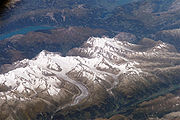
The whole area, including other glaciers is part of the Jungfrau-Aletsch Protected Area
, which was declared a UNESCO World Heritage site in 2001.
 The Aletsch Glacier is one of the many glaciers located between the cantons of Berne
and Valais
on the Bernese Alps located east of the Gemmi Pass
. The whole area is considered to be the largest glaciated area in western Eurasia. The Fiescher
and Aar
glaciers lying on the east have similar extensions.
 Except the Finsteraarhorn
, all the highest summits of the Bernese Alps are located within the drainage basin of the glacier. The Jungfrau
and Mönch
constitute the northern boundary; the Gross Fiescherhorn and Gross Wannenhorn
lie on its east side; finally the culminating point, the Aletschhorn
(4,195 meters/13,763 feet) is located on the west side.
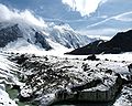
Before reaching the maximum flow, three smaller glaciers converge at Concordia
(German: Konkordiaplatz):
 Below Concordia the glacier runs towards the valley of the Upper Rhône; on the left (east) side, near Bettmeralp
, lies a glacier lake, Lake Märjelen
(2,350 meters/7,711 feet); on the right side lie the glaciers of Mittelaletsch
and Oberaletsch
. At the end of the glacier, below the villages of Belalp
(west) and Riederalp
(east), begin the Massa river. The river flows through gorges and through the Lake Gibidum before reaching the Rhone
near Brig
.
, Riederalp
and Bettmeralp
(which is called Aletsch Region) in Valais
gives access to the lower part of the glacier. The Bettmerhorn
and Eggishorn
are popular view points and are accessible by cable car. The Massa river can be crossed since 2008 by a suspension bridge, thus allowing hikes between the left and the right part of the glacier.
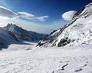
The Jungfraujoch
railway station (3,450 m) gives a direct access to the upper Aletsch Glacier as well as the normal route to the Jungfrau
. It can be reached only from Interlaken
in the canton Berne
. Glacier tours can be done with the help of the Konkordia Hut
or the Hollandia Hut, eventually reaching other glaciers in the massif.
On the Riederfurka, at 2,065 metres between Riederalp and the glacier, is located the historic Villa Cassel, former summer residence of many numerous famous and influential guests from the worlds of politics and finance. The house is now one of the centers of the environmental organization Pro Natura, which hosts a permanent exhibition about the site.
 Also at the mouth of the Konkordiaplatz from the east is the small but important Grüneggfirn (3 km long and averaging 600 m wide). This firn is connected in the over the glacier pass Grünhornlücke (3280 m high) to the Fiescher Glacier
in the east.
From the Konkordiaplatz, the Aletsch Glacier has a width of approximately 1.5 km and moves at a rate of 180 m per year to the southeast on course with the Rhône
valley, bordering the Dreieckhorn in the west and the great Wannenhorn in the east. It then takes a great right turn and bends ever closer to the southwest, running through the edge of the Eggishorn
and Bettmerhorn
of the Rhone valley. The lowest part of the great Aletsch Glacier is largely covered with detritus of the lateral and medial moraine
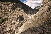
s. The glacier's toe currently lies about 1560 m high, far beneath the local tree line. From it springs the Massa stream, which flows though the Massa Canyon and is used to generate hydroelectric power. It continues through the upper half of the Brig
, eventually entering into the Rhone.
 The great Aletsch Glacier shows considerable ice cover. At the Konkordiaplatz, it has an ice cover of more than 900 m, but as it moves to the south, the greater part of the ice melts, gradually decreasing the cover to around 150 m.
The characteristically dark medial moraine, situated almost in the middle of the glacier, runs protracted in two bands from the Konkordiaplatz along the whole length to the glacier's toe-zone. This medial moraine is collected from the ice of three large ice fields, which all run together. The westernmost medial moraine has been named the Kranzbergmoräne, and the easternmost carries the name Trugbergmoräne.
 The Aletsch Glacier resulted from the accumulation and compaction of snow. Glaciers generally form where snow and ice accumulation exceeds snow and ice melt. As the snow and ice thicken it reaches a point where it begins to move due to a combination of gravity and pressure of the overlying snow and ice.
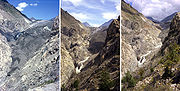
During the last glacial periods, the Aletsch Glacier was much larger than now. 18,000 years ago the lower part of the ridge, between Riederalp and the glacier, was completely covered by ice. Only the summits of the Bettmerhorn, Eggishorn and the Fusshörner were above the glacier. After an important retreat, the glacier again advanced 11,000 years ago during the last glacial period. The glacier reached the Rhone valley, and its ice the Riederfurka. Remaining moraine
s are still visible in the Aletsch Forest.
Since the last glaciation, the glacier generally retreated. However slight climatic changes happened and, in 1860, the glacier was 3 km longer and the ice level 200 m higher.
As for many other glaciers, records show a major longer-term retreat trend.
On August 18th, 2007, photographer Spencer Tunick
used hundreds of naked people in a "living sculpture" on the Aletsch Glacier in a photo shoot intended to draw attention to global warming
and the shrinking of the world's glaciers. The temperature was about 10 °C (50 °F) at the time of the photo shoot. The 600 participants on the shrinking glacier volunteered for Tunick (a collaboration with Greenpeace) to let the world know about the effects of global warming
on the melting Swiss glaciers. The Aletsch Glacier receded by 100 m (328.1 ft) between 2005 and 2006.
Glacier
A glacier is a large persistent body of ice that forms where the accumulation of snow exceeds its ablation over many years, often centuries. At least 0.1 km² in area and 50 m thick, but often much larger, a glacier slowly deforms and flows due to stresses induced by its weight...
in the Alps
Alps
The Alps is one of the great mountain range systems of Europe, stretching from Austria and Slovenia in the east through Italy, Switzerland, Liechtenstein and Germany to France in the west....
. It has a length of about 23 km (14.3 mi) and covers more than 120 square kilometres (46.3 sq mi) in the eastern Bernese Alps
Bernese Alps
The Bernese Alps are a group of mountain ranges in the western part of the Alps, in Switzerland. Although the name suggests that they are located in the Bernese Oberland region of the canton of Bern, portions of the Bernese Alps are in the adjacent cantons of Valais, Lucerne, Obwalden, Fribourg and...
in the Swiss
Switzerland
Switzerland name of one of the Swiss cantons. ; ; ; or ), in its full name the Swiss Confederation , is a federal republic consisting of 26 cantons, with Bern as the seat of the federal authorities. The country is situated in Western Europe,Or Central Europe depending on the definition....
canton of Valais
Valais
The Valais is one of the 26 cantons of Switzerland in the southwestern part of the country, around the valley of the Rhône from its headwaters to Lake Geneva, separating the Pennine Alps from the Bernese Alps. The canton is one of the drier parts of Switzerland in its central Rhône valley...
. The Aletsch Glacier is composed by three smaller glaciers converging at Concordia
Konkordiaplatz
The Konkordiaplatz or Concordia , is a large flat area of snow and ice lying just to the south of the Jungfrau in the Bernese Alps in the Swiss canton of Valais. Its notable feature is that it is the junction of four large glaciers coming down from the Aletschfirn, the Jungfraufirn, the...
, where its thickness is estimated to be near 1 km (3,280.8 ft). It then continues towards the Rhone
Rhône
Rhone can refer to:* Rhone, one of the major rivers of Europe, running through Switzerland and France* Rhône Glacier, the source of the Rhone River and one of the primary contributors to Lake Geneva in the far eastern end of the canton of Valais in Switzerland...
valley before giving birth to the Massa River.
The whole area, including other glaciers is part of the Jungfrau-Aletsch Protected Area
Jungfrau-Aletsch Protected Area
The Jungfrau-Aletsch protected area is located in south-western Switzerland between the cantons of Berne and Valais. It is a mountainous region in the easternmost side of the Bernese Alps, containing the northern wall of Jungfrau and Eiger, and the largest glaciated area in western Eurasia,...
, which was declared a UNESCO World Heritage site in 2001.
Geography
Canton of Berne
The Canton of Bern is the second largest of the 26 Swiss cantons by both surface area and population. Located in west-central Switzerland, it borders the Canton of Jura and the Canton of Solothurn to the north. To the west lie the Canton of Neuchâtel, the Canton of Fribourg and Vaud. To the south...
and Valais
Valais
The Valais is one of the 26 cantons of Switzerland in the southwestern part of the country, around the valley of the Rhône from its headwaters to Lake Geneva, separating the Pennine Alps from the Bernese Alps. The canton is one of the drier parts of Switzerland in its central Rhône valley...
on the Bernese Alps located east of the Gemmi Pass
Gemmi Pass
Gemmi Pass is a high mountain pass across the Bernese Alps connecting Leukerbad in the canton of Valais in Switzerland with Kandersteg in the canton of Bern....
. The whole area is considered to be the largest glaciated area in western Eurasia. The Fiescher
Fiescher Glacier
The Fiescher Glacier is a valley glacier on the south side of the Bernese Alps in the canton of Valais, Switzerland. in length, it is the second longest glacier in the Alps...
and Aar
Aar Glaciers
The Aar Glaciers are glaciers located at the sources of the Aar River in the Bernese Alps, Switzerland. They are constituted by two distinct glacier systems:...
glaciers lying on the east have similar extensions.
Finsteraarhorn
The Finsteraarhorn is the highest mountain in the Bernese Alps and the highest mountain in the canton of Berne. It is also the highest summit in the Alps lying outside the main chain, or watershed. The Finsteraarhorn is the ninth highest and third most prominent peak in the Alps...
, all the highest summits of the Bernese Alps are located within the drainage basin of the glacier. The Jungfrau
Jungfrau
The Jungfrau is one of the main summits in the Bernese Alps, situated between the cantons of Valais and Bern in Switzerland...
and Mönch
Mönch
The Mönch is a mountain in the Bernese Alps, in Switzerland. Together with the Eiger and the Jungfrau it forms a highly recognisable group of mountains visible from far away....
constitute the northern boundary; the Gross Fiescherhorn and Gross Wannenhorn
Gross Wannenhorn
The Gross Wannenhorn is a mountain in the Bernese Alps. It is located in the canton of Valais near the village of Fiesch. The mountain separates the Aletsch Glacier from the Fiescher Glacier....
lie on its east side; finally the culminating point, the Aletschhorn
Aletschhorn
The Aletschhorn is a mountain in the Alps in Switzerland, lying within the Jungfrau-Aletsch region, which has been designated a World Heritage Site by UNESCO...
(4,195 meters/13,763 feet) is located on the west side.
Before reaching the maximum flow, three smaller glaciers converge at Concordia
Konkordiaplatz
The Konkordiaplatz or Concordia , is a large flat area of snow and ice lying just to the south of the Jungfrau in the Bernese Alps in the Swiss canton of Valais. Its notable feature is that it is the junction of four large glaciers coming down from the Aletschfirn, the Jungfraufirn, the...
(German: Konkordiaplatz):
- From the western mouth flows the Great Aletschfirn, which runs along the northern foot of the AletschhornAletschhornThe Aletschhorn is a mountain in the Alps in Switzerland, lying within the Jungfrau-Aletsch region, which has been designated a World Heritage Site by UNESCO...
and DreieckhornDreieckhornDreieckhorn is a mountain in the Bernese Alps in Switzerland.-External links:*...
. The Aletschfirn is supplied from the north by three notable firnFirnFirn is partially-compacted névé, a type of snow that has been left over from past seasons and has been recrystallized into a substance denser than névé. It is ice that is at an intermediate stage between snow and glacial ice...
s: the Ebnefluhfirn, the Gletscherhornfirn, and the Kranzberfirn. All of these Firns have their starting points at around 3800 m. From the Ebnefluhfirns to the Konkordiaplatz, the Aletschfirn is 9 km long and is on average about 1.5 km wide. From the west, the Aletschfirn flows over the 3173 m high glacier pass, the LötschenlückeLötschenlückeThe Lötschenlücke is a high mountain pass in the Bernese Alps, connecting the Lötschental valley to the Aletsch Glacier in the canton of Valais in Switzerland. A hut is located above the col at 3240 m....
, connecting with the Langgletscher, and then into the LötschentalLötschentalThe Lötschental is the largest valley on the northern side of the Rhône valley in the canton of Valais in Switzerland. It lies in the Bernese Alps, with the river Lonza running down the length of the valley from its source within the Langgletscher....
valley.
- From the northwestern mouth flows the Jungfraufirn. This firn in fact represents the straight continuation of the Aletsch Glacier, yet is the shortest of the three tributary glaciers. It has its origin on the southern flank of the MönchMönchThe Mönch is a mountain in the Bernese Alps, in Switzerland. Together with the Eiger and the Jungfrau it forms a highly recognisable group of mountains visible from far away....
, at the Jungfraujoch and at the eastern flank of the Jungfrau. Up to the Konkordiaplatz, the Jungfraufirn is a scarce 7 km long, and returns to flank the KranzbergKranzbergKranzberg is a municipality in the district of Freising in Bavaria in Germany....
in the west and the TrugbergTrugbergThe Trugberg is a mountain in the Bernese Alps in Switzerland. It is located above the Konkordiaplatz where the névé of the Jungfraufirn on the west side and the Ewigschneefeld on the east side converge to form the Aletsch Glacier. The Trugberg lies south of the Mönch.In 1841 a group of explorers...
in the east. At its highest point, it is 2 km wide, and further down it is still a good 1 km wide.
- From the northern mouth flows the Ewigschneefeld (Eternal snow field), where its starting point takes the east flank of the Mönchs. In an elbow, it flanks from Trugberg in the west and the FiescherhornFiescherhornThe Gross Fiescherhorn is a mountain in the Bernese Alps range of the Swiss Alps. At 4,049 metres above sea level, its summit culminates over the whole Fiescherhorn massif, which is also composed of the slightly lower Hinter Fiescherhorn and Klein Fiescherhorn...
and GrünhornGrünhornThe Grünhorn is a mountain in the Bernese Alps range of the Swiss Alps. It is located on the ridge between the two largest glaciers of the Alps: the Aletsch Glacier to the west and the Fiescher Glacier to the east...
in the east, flowing on to the Konkordiaplatz. Up to here, it is about 8 km long and averages about 1.2 km wide. The mouth at the Konkordplatz it follows over a rise with a descent from 25 to 30 percent; here, the glacier is sharply split. Against the north is the Ewigschneefeld over the snow-covered pass of the Lower Mönchsjochs (3529 m high), connected with the catchment area of the Lower Grindelwald GlacierLower Grindelwald GlacierThe Lower Grindelwald Glacier is the western one and the largest of the two Grindelwald Glaciers in the Bernese Alps, south of Grindelwald, the other being the Upper Grindelwald Glacier.The Lower Grindelwald Glacier covers an area of ....
. Through the Higher Mönchsjoch (3627 m high) between the Mönch and the Trugberg stands a connection to the Jungfraufirn.
Bettmeralp
Bettmeralp is a village and ski resort in the Swiss canton of Valais, 1'957 m above sea level, in the municipality of Betten.Bettmeralp is a car free village which can be reached by cable car from the Betten train station . From there another cable car leads near to the summit of Bettmerhorn, which...
, lies a glacier lake, Lake Märjelen
Märjelensee
Märjelensee is a lake in the canton of Valais, Switzerland. It formed on the eastern side of the Aletsch Glacier in the 19th century....
(2,350 meters/7,711 feet); on the right side lie the glaciers of Mittelaletsch
Mittelaletsch Glacier
The Mittelaletsch Glacier is a 5 km long glacier situated in the Bernese Alps in the canton of Valais in Switzerland. In 1973 it had an area of 8.31 km².-External links:*...
and Oberaletsch
Oberaletsch Glacier
The Oberaletsch Glacier is a valley glacier on the south side of the Bernese Alps, in the canton of Valais. It has a length of with an average width of just under and an area of about ....
. At the end of the glacier, below the villages of Belalp
Belalp
Belalp is a village and ski resort in the Swiss canton of Valais, 2'100 m above sea level, in the municipality of Naters.Belalp is a car free village which can be reached by cable car from the village of Blatten. Because of its altitude the place is also a vantage point offering view of Dom and...
(west) and Riederalp
Riederalp
Riederalp is a municipality in the district of Raron in the canton of Valais in Switzerland. It was created in 2003 through the merger of Goppisberg, Greich and Ried-Mörel.-Geography:...
(east), begin the Massa river. The river flows through gorges and through the Lake Gibidum before reaching the Rhone
Rhône
Rhone can refer to:* Rhone, one of the major rivers of Europe, running through Switzerland and France* Rhône Glacier, the source of the Rhone River and one of the primary contributors to Lake Geneva in the far eastern end of the canton of Valais in Switzerland...
near Brig
Brig, Switzerland
Brig, officially Brig-Glis is a municipality in the district of Brig in the canton of Valais in Switzerland.The current municipality was formed in 1972 through the merger of Brig , Brigerbad and Glis.-History:...
.
Tourism
The area of the Aletsch Glacier and some surrounding valleys is on the UNESCO World Heritage list, thus it is protected and the facilities are mostly restricted the external zones. The region between BelalpBelalp
Belalp is a village and ski resort in the Swiss canton of Valais, 2'100 m above sea level, in the municipality of Naters.Belalp is a car free village which can be reached by cable car from the village of Blatten. Because of its altitude the place is also a vantage point offering view of Dom and...
, Riederalp
Riederalp
Riederalp is a municipality in the district of Raron in the canton of Valais in Switzerland. It was created in 2003 through the merger of Goppisberg, Greich and Ried-Mörel.-Geography:...
and Bettmeralp
Bettmeralp
Bettmeralp is a village and ski resort in the Swiss canton of Valais, 1'957 m above sea level, in the municipality of Betten.Bettmeralp is a car free village which can be reached by cable car from the Betten train station . From there another cable car leads near to the summit of Bettmerhorn, which...
(which is called Aletsch Region) in Valais
Valais
The Valais is one of the 26 cantons of Switzerland in the southwestern part of the country, around the valley of the Rhône from its headwaters to Lake Geneva, separating the Pennine Alps from the Bernese Alps. The canton is one of the drier parts of Switzerland in its central Rhône valley...
gives access to the lower part of the glacier. The Bettmerhorn
Bettmerhorn
The Bettmerhorn is a mountain in the Bernese Alps of Valais, Switzerland. The summit can be reached with a 30 minute vertical hike after ascending most of the mountain by cable car from the car free village of Bettmeralp...
and Eggishorn
Eggishorn
The Eggishorn is a mountain in the Bernese Alps, Valais, Switzerland.It lies within the Jungfrau-Aletsch-Bietschhorn region, which has been designated by UNESCO as a World Heritage Site. On its northern flank is the Aletsch Glacier. From the summit the view extends also to the Lepontine and Pennine...
are popular view points and are accessible by cable car. The Massa river can be crossed since 2008 by a suspension bridge, thus allowing hikes between the left and the right part of the glacier.
The Jungfraujoch
Jungfraujoch
The Jungfraujoch is a col or saddle between the Mönch and the Jungfrau in the Bernese Alps on the boundary between the cantons of Bern and Valais, inside the Jungfrau-Aletsch Protected Area....
railway station (3,450 m) gives a direct access to the upper Aletsch Glacier as well as the normal route to the Jungfrau
Jungfrau
The Jungfrau is one of the main summits in the Bernese Alps, situated between the cantons of Valais and Bern in Switzerland...
. It can be reached only from Interlaken
Interlaken
Interlaken is a municipality in the Interlaken-Oberhasli administrative district in the Canton of Bern in Switzerland, a well-known tourist destination in the Bernese Oberland.-History:...
in the canton Berne
Canton of Berne
The Canton of Bern is the second largest of the 26 Swiss cantons by both surface area and population. Located in west-central Switzerland, it borders the Canton of Jura and the Canton of Solothurn to the north. To the west lie the Canton of Neuchâtel, the Canton of Fribourg and Vaud. To the south...
. Glacier tours can be done with the help of the Konkordia Hut
Konkordia Hut
The Konkordia Hut is a mountain hut located in the Bernese Alps in the canton of Valais in Switzerland. It is owned by the Swiss Alpine Club....
or the Hollandia Hut, eventually reaching other glaciers in the massif.
On the Riederfurka, at 2,065 metres between Riederalp and the glacier, is located the historic Villa Cassel, former summer residence of many numerous famous and influential guests from the worlds of politics and finance. The house is now one of the centers of the environmental organization Pro Natura, which hosts a permanent exhibition about the site.
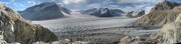
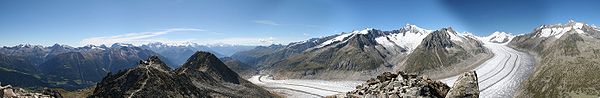
Panorama Picture
Fiescher Glacier
The Fiescher Glacier is a valley glacier on the south side of the Bernese Alps in the canton of Valais, Switzerland. in length, it is the second longest glacier in the Alps...
in the east.
From the Konkordiaplatz, the Aletsch Glacier has a width of approximately 1.5 km and moves at a rate of 180 m per year to the southeast on course with the Rhône
Rhône River
The Rhone is one of the major rivers of Europe, rising in Switzerland and running from there through southeastern France. At Arles, near its mouth on the Mediterranean Sea, the river divides into two branches, known as the Great Rhone and the Little Rhone...
valley, bordering the Dreieckhorn in the west and the great Wannenhorn in the east. It then takes a great right turn and bends ever closer to the southwest, running through the edge of the Eggishorn
Eggishorn
The Eggishorn is a mountain in the Bernese Alps, Valais, Switzerland.It lies within the Jungfrau-Aletsch-Bietschhorn region, which has been designated by UNESCO as a World Heritage Site. On its northern flank is the Aletsch Glacier. From the summit the view extends also to the Lepontine and Pennine...
and Bettmerhorn
Bettmerhorn
The Bettmerhorn is a mountain in the Bernese Alps of Valais, Switzerland. The summit can be reached with a 30 minute vertical hike after ascending most of the mountain by cable car from the car free village of Bettmeralp...
of the Rhone valley. The lowest part of the great Aletsch Glacier is largely covered with detritus of the lateral and medial moraine
Moraine
A moraine is any glacially formed accumulation of unconsolidated glacial debris which can occur in currently glaciated and formerly glaciated regions, such as those areas acted upon by a past glacial maximum. This debris may have been plucked off a valley floor as a glacier advanced or it may have...
s. The glacier's toe currently lies about 1560 m high, far beneath the local tree line. From it springs the Massa stream, which flows though the Massa Canyon and is used to generate hydroelectric power. It continues through the upper half of the Brig
Brig, Switzerland
Brig, officially Brig-Glis is a municipality in the district of Brig in the canton of Valais in Switzerland.The current municipality was formed in 1972 through the merger of Brig , Brigerbad and Glis.-History:...
, eventually entering into the Rhone.
The characteristically dark medial moraine, situated almost in the middle of the glacier, runs protracted in two bands from the Konkordiaplatz along the whole length to the glacier's toe-zone. This medial moraine is collected from the ice of three large ice fields, which all run together. The westernmost medial moraine has been named the Kranzbergmoräne, and the easternmost carries the name Trugbergmoräne.
Formation and evolution
During the last glacial periods, the Aletsch Glacier was much larger than now. 18,000 years ago the lower part of the ridge, between Riederalp and the glacier, was completely covered by ice. Only the summits of the Bettmerhorn, Eggishorn and the Fusshörner were above the glacier. After an important retreat, the glacier again advanced 11,000 years ago during the last glacial period. The glacier reached the Rhone valley, and its ice the Riederfurka. Remaining moraine
Moraine
A moraine is any glacially formed accumulation of unconsolidated glacial debris which can occur in currently glaciated and formerly glaciated regions, such as those areas acted upon by a past glacial maximum. This debris may have been plucked off a valley floor as a glacier advanced or it may have...
s are still visible in the Aletsch Forest.
Since the last glaciation, the glacier generally retreated. However slight climatic changes happened and, in 1860, the glacier was 3 km longer and the ice level 200 m higher.
As for many other glaciers, records show a major longer-term retreat trend.
On August 18th, 2007, photographer Spencer Tunick
Spencer Tunick
Spencer Tunick is an American photographer. Tunick is best known for organizing large-scale nude shoots. Since 1994 he has photographed over 75 human installations around the world.-Biography:...
used hundreds of naked people in a "living sculpture" on the Aletsch Glacier in a photo shoot intended to draw attention to global warming
Global warming
Global warming refers to the rising average temperature of Earth's atmosphere and oceans and its projected continuation. In the last 100 years, Earth's average surface temperature increased by about with about two thirds of the increase occurring over just the last three decades...
and the shrinking of the world's glaciers. The temperature was about 10 °C (50 °F) at the time of the photo shoot. The 600 participants on the shrinking glacier volunteered for Tunick (a collaboration with Greenpeace) to let the world know about the effects of global warming
Global warming
Global warming refers to the rising average temperature of Earth's atmosphere and oceans and its projected continuation. In the last 100 years, Earth's average surface temperature increased by about with about two thirds of the increase occurring over just the last three decades...
on the melting Swiss glaciers. The Aletsch Glacier receded by 100 m (328.1 ft) between 2005 and 2006.