

Alberni Valley
Encyclopedia
The Alberni Valley is located on Vancouver Island
. Home to both Port Alberni, Sproat Lake
and other outlining areas. The term is largely used as a synonym for Greater Port Alberni and adjoining communities but is used in a larger regional sense as well.
Vancouver Island
Vancouver Island is a large island in British Columbia, Canada. It is one of several North American locations named after George Vancouver, the British Royal Navy officer who explored the Pacific Northwest coast of North America between 1791 and 1794...
. Home to both Port Alberni, Sproat Lake
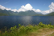
Sproat Lake
Sproat Lake, named after Gilbert Malcolm Sproat, is a lake in central Vancouver Island. Home of the last Martin Mars type Waterbombers, and near Port Alberni, Sproat Lake is a summer hangout for the Alberni Valley. Highway 4 runs along its scenic north shore....
and other outlining areas. The term is largely used as a synonym for Greater Port Alberni and adjoining communities but is used in a larger regional sense as well.
Geography
- Mount ArrowsmithMount ArrowsmithMount Arrowsmith is the largest mountain on southern Vancouver Island. Its dominant rock is basalt. The mountain is contained within a UNESCO Biosphere Reserve and as of September 18, 2009 is designated part of 1,300 hectare Mt. Arrowsmith Regional Park....
is the largest mountain on southern Vancouver Island. It has some of the most accessible alpine and sub-alpine areas for Victoria and other large towns on the Island. These zones contain several rare and endangered species of plants and animals, the most notable of which is the Vancouver Island MarmotVancouver Island MarmotThe Vancouver Island marmot naturally occurs only in the high mountains of Vancouver Island, in British Columbia, Canada. This particular marmot species is large compared to some other marmots, and most other rodents...
, which has the dubious distinction of being Canada's rarest mammal. Although the mountain is contained within a UNESCO Biosphere Reserve it is not part of a park. Efforts are currently underway to confer official park status on the alpine areas of the Arrowsmith massif and surrounding areas. - Beaufort RangeBeaufort RangeThe Beaufort Range is a mountain range on southern Vancouver Island, British Columbia, Canada, located north of Port Alberni and to the west of Qualicum Beach. It has an area of 448 km2 and is a subrange of the Vancouver Island Ranges which in turn form part of the Insular Mountains.The highest...
North of Port Alberni and west of Qualicum Beach. - Ash Lake
- Buttle LakeButtle LakeButtle Lake is a lake on Vancouver Island in Strathcona Regional District, British Columbia, Canada. It is about long and side, has an area of , is up to deep, and lies at an elevation of . The lake is located between Campbell River and Gold River in Strathcona Provincial Park; there is a...
- Cameron LakeCameron Lake (British Columbia)Cameron Lake is a lake in central Vancouver Island located 15 km east of Port Alberni, on the north side of Highway 4. It has an area of 477 hectares and an elevation of 184 metres above sea level. The lake is between Mount Arrowsmith to the south and Mount Wesley to the north...
- Devils Den LakeDevils Den LakeDevils Den Lake is a small lake located on Vancouver Island four kilometres west of Port Alberni, British Columbia....
- Dickson Lake
- Doran Lake
- Elsie Lake
- Esary LakeEsary LakeEsary Lake is a small lake located east of Port Alberni, British Columbia. It lies west of Horne Lake....
- Father and Son LakeFather and Son LakeFather and Son Lake is a lake located on Vancouver Island at the head of Franklin River....
- Gracie LakeGracie LakeGracie Lake is a lake located on Vancouver Island north west of the north end of Nahmint Lake....
- Great Central LakeGreat Central LakeGreat Central Lake is a lake on Vancouver Island, British Columbia, Canada. Great Central lake has a depth of 293 metres , making it the second deepest lake on Vancouver Island...
is a large lake in the Alberni Valley The lake has a surface area of 51 square kilometres and a maximum depth of 294 m. It takes it name from the fact that it is a large lake in the center of Vancouver Island. - Hederson Lake
- Henry LakeHenry Lake-References:*...
- Horne LakeHorne LakeHorne Lake is located west of Qualicum Beach. Named after Adam Grant Horne, Hudson's Bay Company storekeeper at Nanaimo, who 'discovered' this lake in 1856....
- Kammat LakeKammat LakeKammat Lake is a lake located on Vancouver Island at the head of Kammat Creek south of Cameron River....
- Kennedy LakeKennedy LakeKennedy Lake is the largest lake on Vancouver Island, British Columbia, Canada. Located northeast of Ucluelet on the Island's central west coast, the lake is formed chiefly by the confluence of the Clayoquot and Kennedy Rivers. Outflow is via a short stretch of the Kennedy River into Tofino...
is the largest lakeLakeA lake is a body of relatively still fresh or salt water of considerable size, localized in a basin, that is surrounded by land. Lakes are inland and not part of the ocean and therefore are distinct from lagoons, and are larger and deeper than ponds. Lakes can be contrasted with rivers or streams,...
on Vancouver IslandVancouver IslandVancouver Island is a large island in British Columbia, Canada. It is one of several North American locations named after George Vancouver, the British Royal Navy officer who explored the Pacific Northwest coast of North America between 1791 and 1794...
, British ColumbiaBritish ColumbiaBritish Columbia is the westernmost of Canada's provinces and is known for its natural beauty, as reflected in its Latin motto, Splendor sine occasu . Its name was chosen by Queen Victoria in 1858...
, CanadaCanadaCanada is a North American country consisting of ten provinces and three territories. Located in the northern part of the continent, it extends from the Atlantic Ocean in the east to the Pacific Ocean in the west, and northward into the Arctic Ocean...
. Located northeast of Ucluelet on the Island's central west coast, the lake is formed chiefly by the confluence of the Clayoquot and Kennedy Rivers. - Labour Day LakeLabour Day LakeLabour Day Lake is a lake located on Vancouver Island at the head of the Cameron River...
- Lacy LakeLacy LakeLacy Lake is a small lake located east of Port Alberni, British Columbia. It lies south east of Esary Lake. It is the main water supply for the Cherry Creek Improvement District....
- Little Toquart Lake
- Lizard Pond
- Lowry LakeLowry LakeLowry Lake is a lake located on Vancouver Island north of Great Central Lake, west of Dickson Lake....
- Long Lake
- McLaughlin Lake
- Maggie Lake
- Marshy LakeMarshy LakeMarshy Lake is a lake located on Vancouver Island south of western end of Horne Lake....
- Muriel LakeMuriel LakeMuriel Lake is a lake located on Vancouver Island west of Clayoquot Arm and north of Kennedy River....
- Nahmint LakeNahmint LakeNahmint Lake is a lake located on Vancouver Island south of Sproat Lake, north east of Henderson Lake....
- Nitinat LakeNitinat LakeNitinat Lake is a large lake and inlet on the southwestern coast of Vancouver Island, British Columbia, Canada. The lake is about northwest by road from Victoria, BC's capital on the southern tip of Vancouver Island, and about southeast by road from the town of Lake Cowichan...
- Sproat LakeSproat LakeSproat Lake, named after Gilbert Malcolm Sproat, is a lake in central Vancouver Island. Home of the last Martin Mars type Waterbombers, and near Port Alberni, Sproat Lake is a summer hangout for the Alberni Valley. Highway 4 runs along its scenic north shore....
, named after Gilbert Malcolm SproatGilbert Malcolm SproatGilbert Malcolm Sproat was a Scottish-born Canadian businessman, office holder, and author. Arriving on Vancouver Island in 1860, he helped to found the first sawmill in Port Alberni, British Columbia. On 24 July. 1863 he was made the justice of the peace for the Colony of Vancouver Island...
, is a lakeLakeA lake is a body of relatively still fresh or salt water of considerable size, localized in a basin, that is surrounded by land. Lakes are inland and not part of the ocean and therefore are distinct from lagoons, and are larger and deeper than ponds. Lakes can be contrasted with rivers or streams,...
in central Vancouver IslandVancouver IslandVancouver Island is a large island in British Columbia, Canada. It is one of several North American locations named after George Vancouver, the British Royal Navy officer who explored the Pacific Northwest coast of North America between 1791 and 1794...
. Home of the last Martin Mars Waterbombers, and nearby to Port Alberni. - Tsable Lake
- Toquart Lake
- Turnbull LakeTurnbull LakeTurnbull Lake is a lake located on Vancouver Island north of Great Central Lake, south east of Elsie Lake....
- Turtle Lake
- Uchuck LakeUchuck LakeUchuck Lakeis a lake located on Vancouver Island north west of head of Uchucklesit Inlet on the north side of lower Alberni Inlet,...
- Stamp Falls
- Stamp River
- Somass RiverSomass RiverSomass River is a river on Vancouver Island, in the Canadian province of British Columbia. Its drainage basin is in size.The river's name comes from a Nuu-chah-nulth word meaning "washing".-Course:...
- Kennedy River
- Ash River
- Taylor River
- Rogers Creek
- China Creek
- Drinkwater Creek
- Cherry CreekCherry Creek (British Columbia)Cherry Creek is a creek located in the Okanagan region of British Columbia. The south fork of Cherry Creek is known as Monashee Creek. Cherry Creek was discovered in the 1800s and mined for gold. The Creek was mined in the 1800s by Christian, Schneider, Bissett, and Leblanc. Chinese and...
- Beaver CreekBeaver Creek, British ColumbiaBeaver Creek is an unincorporated community in the Alberni Valley of central Vancouver Island in British Columbia, Canada, located northwest of the city of Port Alberni on the east bank of the Stamp River. Beaver Creek had its own post office from July 1, 1890 to November 30, 1939.Gregory Coletti...
- Sproat River
- Alberni Inlet is a long, narrow inlet
 InletAn inlet is a narrow body of water between islands or leading inland from a larger body of water, often leading to an enclosed body of water, such as a sound, bay, lagoon or marsh. In sea coasts an inlet usually refers to the actual connection between a bay and the ocean and is often called an...
in Vancouver IslandVancouver IslandVancouver Island is a large island in British Columbia, Canada. It is one of several North American locations named after George Vancouver, the British Royal Navy officer who explored the Pacific Northwest coast of North America between 1791 and 1794...
, British ColumbiaBritish ColumbiaBritish Columbia is the westernmost of Canada's provinces and is known for its natural beauty, as reflected in its Latin motto, Splendor sine occasu . Its name was chosen by Queen Victoria in 1858...
, CanadaCanadaCanada is a North American country consisting of ten provinces and three territories. Located in the northern part of the continent, it extends from the Atlantic Ocean in the east to the Pacific Ocean in the west, and northward into the Arctic Ocean...
, that stretches from the Pacific OceanPacific OceanThe Pacific Ocean is the largest of the Earth's oceanic divisions. It extends from the Arctic in the north to the Southern Ocean in the south, bounded by Asia and Australia in the west, and the Americas in the east.At 165.2 million square kilometres in area, this largest division of the World...
at Barkley SoundBarkley SoundBarkley Sound, also known historically as Barclay Sound, is south of Ucluelet and north of Bamfield on the west coast of Vancouver Island and forms the entrance to the Alberni Inlet...
about 40 kilometres (25 mi) inland terminating at Port Alberni. - Barkley SoundBarkley SoundBarkley Sound, also known historically as Barclay Sound, is south of Ucluelet and north of Bamfield on the west coast of Vancouver Island and forms the entrance to the Alberni Inlet...
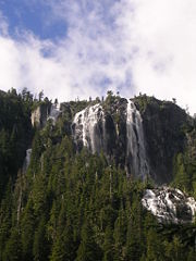
- Della FallsDella FallsDella Falls is a waterfall in Strathcona Provincial Park on Vancouver Island. It is widely regarded as the tallest in Canada, 440 metres , though there is some question as to whether it deserves this title .-Location:...
Della Falls is a waterfall in Strathcona Provincial Park on Vancouver Island. It is widely regarded as the tallest in Canada.