
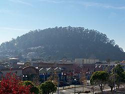
Albany Hill
Encyclopedia

San Francisco Bay
San Francisco Bay is a shallow, productive estuary through which water draining from approximately forty percent of California, flowing in the Sacramento and San Joaquin rivers from the Sierra Nevada mountains, enters the Pacific Ocean...
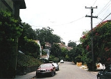
in the city of Albany, California
Albany, California
Albany is a city in Alameda County, California, United States. The population was 18,539 at the 2010 census.-History:In 1908, a group of local women protested the dumping of Berkeley garbage in their community...
. Geologically, the hill is predominantly Jurassic sandstone, carried to the western edge of North America on the Pacific Plate and scraped off there in the course of subduction. Albany Hill is part of a range of hills uplifted long before today's Berkeley Hills. These hills include Fleming Point and Point Isabel (their summits dynamited away), Brooks Island, the Potrero San Pablo, and the hills across San Pablo Strait.
Albany Hill's indigenous Ohlone
Ohlone
The Ohlone people, also known as the Costanoan, are a Native American people of the central California coast. When Spanish explorers and missionaries arrived in the late 18th century, the Ohlone inhabited the area along the coast from San Francisco Bay through Monterey Bay to the lower Salinas Valley...
name is unknown. The 1772 Fages expedition referred to the landmark as "El Serrito," and it was named Cerrito de San Antonio by the Luís María Peralta
Luís María Peralta
Luis María Peralta was a soldier in the Spanish Army, who received one of the largest of the Spanish land grants, Rancho San Antonio, a plot that encompassed most of the East Bay region of California.-Biography:...
family after the name of their ranch, Rancho San Antonio, a Spanish land grant which encompassed much of the East Bay
East Bay (San Francisco Bay Area)
The East Bay is a commonly used, informal term for the lands on the eastern side of the San Francisco Bay, in the San Francisco Bay Area, in California, United States...
. The name was changed to Albany Hill shortly after the city incorporated as Ocean View changed its name to Albany. The adjacent city of El Cerrito
El Cerrito, Contra Costa County, California
-Transportation:The city's primary transportation infrastructure consists of the El Cerrito Plaza and El Cerrito del Norte BART stations along with several local bus lines, operated by AC Transit, providing access to the surrounding area and the nearby cities of Albany, Berkeley and Richmond...
was named after the hill's original Spanish name.
Early history
The north side of Albany Hill was long used by Native Americans, as evidenced by large mortar stones and remnants of a shell midden. Oaks on the north side, the willow grove where tributary Middle Creek joins Cerrito Creek, salt and fresh wetlands to the north (now filled), and the nearby Bay would have made this a bountiful seasonal home.Beginning in the late 19th century, Judson Powder Works manufactured dynamite at the northwest foot of the hill. The company had been forced to move from San Francisco and then nearby Fleming Point in Berkeley because of continuing accidental explosions. The eucaluptus trees now on the hill were planted by the dynamite manufacturers to catch debris and muffle sound of these explosion. The stop on the transcontinental railroad tracks just to the west was called Nobel Station, after the inventor of dynamite.
In 1905, a massive accidental explosion of nitroglycerin killed 23 workers. The explosion carved a massive crater in the north flank of the hill, which is today evident by a large dip in the tree-line. After this incident, dynamite making was forced north to less-settled areas, making an eventual last stand at Pt. Pinole, now a regional park. Quarrying on the hill continued for many years, leaving scars on the rock and eventually obliterating a low summit northwest of Albany Hill, approximately where Richmond
Richmond, California
Richmond is a city in western Contra Costa County, California, United States. The city was incorporated on August 7, 1905. It is located in the East Bay, part of the San Francisco Bay Area. It is a residential inner suburb of San Francisco, as well as the site of heavy industry, which has been...
's Pacific East Mall
Pacific East Mall
Pacific East Mall is an Asian mall in Richmond, California. It is owned by Pacific Infinity Company Incorporated.The mall opened in 1998 in Richmond's Richmond Annex neighborhood but straddling the El Cerrito border at a former Breuner's location...
is now located.
Modern history and ecology
As a large open space, the only nearby high elevation next to the Bay, and in the path of sea winds blowing through the Golden Gate, Albany Hill is an ecological island. It is a haven for plants normally found in much cooler areas, for example Nootka rose (Rosa nutkaensis), stinging phacelia (Phacelia nemoralis), and coast horkelia (Horkelia californica ssp. californica) The Native American practice of regular burning to avoid brush buildup (and major fires) was continued by the dynamite companies and later the city, into the 1960s. Perhaps as a result, the hill harbors unusually large numbers of native wildflowers and other plants. The oak forest on the cool north face remains much as it was pre-European-settlement. The non-native Eucalyptus trees on the summit attract migrating and wintering Monarch butterflies. Hawks, owls, and deer are among the animal inhabitants; herons, kingfishers, and egrets fish the creek.The hill provides a view of Albany
Albany, California
Albany is a city in Alameda County, California, United States. The population was 18,539 at the 2010 census.-History:In 1908, a group of local women protested the dumping of Berkeley garbage in their community...
, Berkeley
Berkeley, California
Berkeley is a city on the east shore of the San Francisco Bay in Northern California, United States. Its neighbors to the south are the cities of Oakland and Emeryville. To the north is the city of Albany and the unincorporated community of Kensington...
— notably, UC Berkeley's Sather Tower
Sather Tower
Sather Tower is a campanile on the University of California, Berkeley campus. It is more commonly known as The Campanile due to its resemblance to the Campanile di San Marco in Venice, and serves as UC Berkeley's most recognizable symbol. It was completed in 1914 and first opened to the public in...
— and the Berkeley Hills
Berkeley Hills
The Berkeley Hills are a range of the Pacific Coast Ranges that overlook the northeast side of the valley that surrounds San Francisco Bay. They were previously called the "Contra Costa Range/Hills" , but with the establishment of Berkeley and the University of California, the current usage was...
from one side. From the other, it looks out onto the Bay
San Francisco Bay
San Francisco Bay is a shallow, productive estuary through which water draining from approximately forty percent of California, flowing in the Sacramento and San Joaquin rivers from the Sierra Nevada mountains, enters the Pacific Ocean...
, with San Francisco
San Francisco, California
San Francisco , officially the City and County of San Francisco, is the financial, cultural, and transportation center of the San Francisco Bay Area, a region of 7.15 million people which includes San Jose and Oakland...
in the distance. Looking south from the Hill, the high-rises in downtown Oakland and Emeryville are visible. From earliest European settlement, residents have enjoyed open space on the hill, "sledding" on dry grass and swinging from rope swings.
From the early 20th Century on, particularly in the 1970s, numerous schemes were proposed for development of Albany Hill, from dynamiting it for bay fill to building high-rise hotels or blasting out the top as a reservoir. Protest by local residents defeated most of these. Eventually the city retained an environmental consultant to prepare an Environmental Impact Report on alternative development schemes and development densities. After a series of public hearings the consultant's recommendation design was chosen leading to the present development pattern of clustered high-rise residential use and preservation of the majority of the hill. In 1996, citizens voted in an advisory measure to buy the open land, and in 2998 they passed Measure R. a special levy including $3 million to buy land on the hill. In 2008, the remaining open space hill was declared a Priority Conservation Area by Bay Area and state agencies. However, as of 2011 the money remained largely unspent, and the city has never rezoned the land, which remains designated for high-rise apartments in its plans.
Just under 3/4 of almost 40 acres of open space on the hill is protected from development. A public park extends from Cerrito Creek
Cerrito Creek
Cerrito Creek is one of the principal watercourses running out of the Berkeley Hills into San Francisco Bay in northern California. It is significant for its use as a boundary demarcation historically, as well as presently. In the early 19th century, it separated the vast Rancho San Antonio to...
up the north side of the hill. Large condominiums on the west side of the hill maintain significant areas of open space as part of thir development agreements, and the north part of the summit ridge and a portion of the northeast slope is owned by the city. However, south of the highest point, an 11-acre privately owned parcel runs from Pierce Street on the west up over the summit and down to Taft Street. Most users treat this land as park, but the city has never negotiated a legal right-of-way allowing public access.
Although the city hired a consultant and adopted a master plan for the park in 1991, as of 2011 it had carried out none of the modest improvements the plan called for, such as improved trails, steps, and signage. Steps and benches were rotten and trails gullied and uneven. The 1991 plan included thinning Eucalyptus and controlling brush to create a savannah-like habitat that would limit fires. However, the city consistently limited spending on vegetation management to a small fraction of the annual interest earned on the unused money levied to buy the private land. On November 15, 2008, strong dry northeast winds whipped up a fire in a forested area on the west side of the hill above a large apartment complex (555 Pierce Street). Recent heavy rains and a prompt response by the Albany and Berkeley fire departments limited the blaze to 2 acres (8,093.7 m²), with no structures burned. Fire remains a serious threat. The city stepped up brush control, although not spending, after the fire. In 2011, the City Council voted to retain a new consultant and create a new plan.
Two volunteer groups work on the Hill. Friends of Albany Hill has worked to maintain native vegetation on the hill itself, while Friends of Five Creeks has done extensive restoration along Cerrito and Middle Creeks and adjoining groves and meadows at the foot of the hill.