
Airton
Encyclopedia
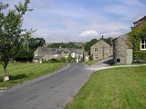
Airton is a small village
and civil parish
in the Craven
district of North Yorkshire
, England
, situated 10 miles (16.1 km) north-west of Skipton
. The local travel links are located 3 miles (4.8 km) from the village to Hellifield railway station
and 23 miles (37 km) to Leeds Bradford International Airport
. Also, the local roads link the village to the A65
. The village has a population of 175 according to the 2001 Census
.
It was known as Airtone in the Domesday Book
. It is in the Yorkshire Dales National Park. Originally a Quaker
village, there is no pub
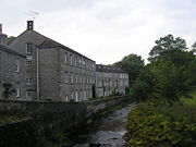
in the village. There is still a Quaker meeting house, a squatter's cottage on the village green and an old mill on the River Aire
from which the village is named. There is no Post Office in the village, however there is a Farm Shop and Tea Room at Town End Farm on the road to Malham
.
The village lies on the main road to the tourist village of Malham. There is a bus stop in the village but no regular bus travel goes through Airton apart from the school buses. Gargrave
is the nearest railway station
to the village.
 The Pennine Way
passes around the edge of the village, alongside the river.
Village
A village is a clustered human settlement or community, larger than a hamlet with the population ranging from a few hundred to a few thousand , Though often located in rural areas, the term urban village is also applied to certain urban neighbourhoods, such as the West Village in Manhattan, New...
and civil parish
Civil parish
In England, a civil parish is a territorial designation and, where they are found, the lowest tier of local government below districts and counties...
in the Craven
Craven
Craven is a local government district in North Yorkshire, England that came into being in 1974, centred on the market town of Skipton. In the changes to British local government of that year this district was formed as the merger of Skipton urban district, Settle Rural District and most of Skipton...
district of North Yorkshire
North Yorkshire
North Yorkshire is a non-metropolitan or shire county located in the Yorkshire and the Humber region of England, and a ceremonial county primarily in that region but partly in North East England. Created in 1974 by the Local Government Act 1972 it covers an area of , making it the largest...
, England
England
England is a country that is part of the United Kingdom. It shares land borders with Scotland to the north and Wales to the west; the Irish Sea is to the north west, the Celtic Sea to the south west, with the North Sea to the east and the English Channel to the south separating it from continental...
, situated 10 miles (16.1 km) north-west of Skipton
Skipton
Skipton is a market town and civil parish within the Craven district of North Yorkshire, England. It is located along the course of both the Leeds and Liverpool Canal and the River Aire, on the south side of the Yorkshire Dales, northwest of Bradford and west of York...
. The local travel links are located 3 miles (4.8 km) from the village to Hellifield railway station
Hellifield railway station
Hellifield railway station serves the village of Hellifield in North Yorkshire, England.The station is north west of Leeds on the Leeds to Morecambe Line towards Carlisle and Morecambe. The Ribble Valley Line from Blackburn also meets the Leeds to Morecambe Line at Hellifield which is managed by...
and 23 miles (37 km) to Leeds Bradford International Airport
Leeds Bradford International Airport
Leeds Bradford International Airport is located at Yeadon, in the City of Leeds Metropolitan District in West Yorkshire, England, northwest of Leeds city centre itself...
. Also, the local roads link the village to the A65
A65 road
The A65 is a major road in England. It runs north west from Leeds in Yorkshire via Kirkstall, Horsforth, Yeadon, Guiseley, Ilkley and Skipton, passes west of Settle, then continues through Ingleton and Kirkby Lonsdale before terminating at Kendal in Cumbria....
. The village has a population of 175 according to the 2001 Census
United Kingdom Census 2001
A nationwide census, known as Census 2001, was conducted in the United Kingdom on Sunday, 29 April 2001. This was the 20th UK Census and recorded a resident population of 58,789,194....
.
It was known as Airtone in the Domesday Book
Domesday Book
Domesday Book , now held at The National Archives, Kew, Richmond upon Thames in South West London, is the record of the great survey of much of England and parts of Wales completed in 1086...
. It is in the Yorkshire Dales National Park. Originally a Quaker
Religious Society of Friends
The Religious Society of Friends, or Friends Church, is a Christian movement which stresses the doctrine of the priesthood of all believers. Members are known as Friends, or popularly as Quakers. It is made of independent organisations, which have split from one another due to doctrinal differences...
village, there is no pub
Public house
A public house, informally known as a pub, is a drinking establishment fundamental to the culture of Britain, Ireland, Australia and New Zealand. There are approximately 53,500 public houses in the United Kingdom. This number has been declining every year, so that nearly half of the smaller...
in the village. There is still a Quaker meeting house, a squatter's cottage on the village green and an old mill on the River Aire
River Aire
The River Aire is a major river in Yorkshire, England of length . Part of the river is canalised, and is known as the Aire and Calder Navigation....
from which the village is named. There is no Post Office in the village, however there is a Farm Shop and Tea Room at Town End Farm on the road to Malham
Malham
Malham is a village and civil parish in the Craven district of North Yorkshire, England. Situated in the Yorkshire Dales with a population of approximately 150. The surrounding countryside is well known for its limestone pavements and other examples of limestone scenery...
.
The village lies on the main road to the tourist village of Malham. There is a bus stop in the village but no regular bus travel goes through Airton apart from the school buses. Gargrave
Gargrave
Gargrave is a small village and civil parish in the Craven district located along the A65, northwest of Skipton in North Yorkshire, England.It is situated on the very edge of the Yorkshire Dales. The River Aire and the Leeds and Liverpool Canal pass through the village...
is the nearest railway station
Gargrave railway station
Gargrave railway station serves the village of Gargrave in North Yorkshire, England. It is north west of Leeds on the Leeds to Morecambe Line operated by Northern Rail who also manage the station....
to the village.
Pennine Way
The Pennine Way is a National Trail in England. The trail runs from Edale, in the northern Derbyshire Peak District, north through the Yorkshire Dales and the Northumberland National Park and ends at Kirk Yetholm, just inside the Scottish border. The path runs along the Pennine hills, sometimes...
passes around the edge of the village, alongside the river.