
Agios Georgios Langoura
Encyclopedia
| Agios Georgios Langoura Άγιος Γεώργιος Λάγγουρα |
|
|---|---|
| Prefecture Prefectures of Greece During the first administrative division of independent Greece in 1833–1836 and then again from 1845 until their abolition with the Kallikratis reform in 2010, the prefectures were the country's main administrative unit... : |
Achaia |
| Province Provinces of Greece The provinces of Greece were sub-divisions of some the country's prefectures. From 1887, the provinces were abolished as actual administrative units, but were retained for some state services, especially finance services and education, as well as for electoral purposes... : |
Patras |
| City: | Patras Patras Patras , ) is Greece's third largest urban area and the regional capital of West Greece, located in northern Peloponnese, 215 kilometers west of Athens... |
| Section: | East |
| Distance from downtown: | 5 km southeast |
| Population: (2001) Total Density Rank |
about 3,000 to 4,000 -/km² |
| Population percentage (2005): | about 3 to 4% |
| Elevation: -lowest: -centre: -highest: |
Ionian Sea Ionian Sea The Ionian Sea , is an arm of the Mediterranean Sea, south of the Adriatic Sea. It is bounded by southern Italy including Calabria, Sicily and the Salento peninsula to the west, southern Albania to the north, and a large number of Greek islands, including Corfu, Zante, Kephalonia, Ithaka, and... 10 m (centre) about 20 m (east) |
| Area/distance code: | 11-0030-2610 |
| Image | |
 |
|
Agios Georgios Langoura (Greek: Άγιος Γεώργιος Λάγγουρα) is a neighbourhood in the eastern portion Patras
Patras
Patras , ) is Greece's third largest urban area and the regional capital of West Greece, located in northern Peloponnese, 215 kilometers west of Athens...
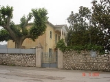
. The name comes from a nearby church and the rich family of Langoura
Langoura
The Langoura or Laggoura family were a family in Patras, Greece in the neighbourhood of Agios Georgios Langoura that were company owners....
, their house still survives into the present time. During the Turkish rule
Ottoman Empire
The Ottoman EmpireIt was usually referred to as the "Ottoman Empire", the "Turkish Empire", the "Ottoman Caliphate" or more commonly "Turkey" by its contemporaries...
it had all the consulates and the residents of the consulates. In the neighbourhood is the Pampeloponnisiakos Stadium.
Streets
- Genisseos Street
- Kalavryton Street (partly residential)
- Patron-Klaous Road
Geography
The western and central portions are made up of residential area. The eastern and the outer portions are still made up of farmlands.History
Farmlands dominated the area and were made up of fruits and vegetables including tomatoes, potatoes, cattle, olives and other crops until the 1970s. Its population used to work on agriculture. Housing developments did not arrive until the 1960s with six to eight story residential buildings. It extended into the western portion, the central portion in the 1970s and the eastern portion in the 1980s and the 1990s. Its street plan are mainly parallel, the divided street is to the south. Housing developments are steadily growing as it extends slowly to the east.Panorama
Its panorama includes the PanachaikoPanachaiko
The Panachaikon or Panachaiko , also known as Vodias in medieval times and until the early 20th century, is a mountain range that spans about 20 km in length from north to south , and 15 to 20 km from east to west...
mountains to the east as well as its nearby hills, more to the south and southeast including Omplos
Omplos
Omplos is a mountain in the northern part of Achaea, Greece. It rises 720 m above sea level. The mountain is shaped like a sugar-loaf, with a 65° slope. The mountain can be reached by three unused roads, one that leads almost to the top of the mountain, one linking to Ovrya in the West, and...
, Varasova
Varasova
Varasova or Varassova mountain is a mountain range dominating the northern part of the Aitolia-Akarnania prefecture in western Greece. Its length is approximately 7 km long from northwest to southeast and its width is approximately 2 km wide from southeast to northwest...
and Arakynthos
Arakynthos
Arakynthos is a former municipality in Aetolia-Acarnania, West Greece, Greece. Since the 2011 local government reform it is part of the municipality Agrinio, of which it is a municipal unit. It consists of the villages of Ano Kerasovo, Kato Kerasovo, Zevgaraki, Papadates , Mataranga and Grammatikou....
to the west and northwest and more to the north. They are blocked by buildings to the east.