

Active Traffic Management
Encyclopedia
Germany
Germany , officially the Federal Republic of Germany , is a federal parliamentary republic in Europe. The country consists of 16 states while the capital and largest city is Berlin. Germany covers an area of 357,021 km2 and has a largely temperate seasonal climate...
, the United Kingdom
United Kingdom
The United Kingdom of Great Britain and Northern IrelandIn the United Kingdom and Dependencies, other languages have been officially recognised as legitimate autochthonous languages under the European Charter for Regional or Minority Languages...
, and the United States
United States
The United States of America is a federal constitutional republic comprising fifty states and a federal district...
. It makes use of automatic systems and human intervention to manage traffic flow and ensure the safety of road users.
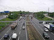
In the United Kingdom
It is currently in operation on the M42 motorwayM42 motorway
The M42 motorway is a major road in England. The motorway runs north east from Bromsgrove in Worcestershire to just south west of Ashby-de-la-Zouch in Leicestershire, passing Redditch, Solihull, the National Exhibition Centre and Tamworth on the way. The section between the M40 and M6 road forms...
south-east of Birmingham
Birmingham
Birmingham is a city and metropolitan borough in the West Midlands of England. It is the most populous British city outside the capital London, with a population of 1,036,900 , and lies at the heart of the West Midlands conurbation, the second most populous urban area in the United Kingdom with a...
and in Warwickshire
Warwickshire
Warwickshire is a landlocked non-metropolitan county in the West Midlands region of England. The county town is Warwick, although the largest town is Nuneaton. The county is famous for being the birthplace of William Shakespeare...
. The scheme had initially been criticised by some due to possible safety and environmental concerns, however a Highways Agency report into the first six months of the scheme scheme showed a reduction in the number of accidents from over 5 a month to 1.5 per month on average. it has now been expanded onto other roads following the initial trial
Evaluation
Evaluation is systematic determination of merit, worth, and significance of something or someone using criteria against a set of standards.Evaluation often is used to characterize and appraise subjects of interest in a wide range of human enterprises, including the arts, criminal justice,...
on the M42. It is seen as a less expensive alternative to widening a road
Road
A road is a thoroughfare, route, or way on land between two places, which typically has been paved or otherwise improved to allow travel by some conveyance, including a horse, cart, or motor vehicle. Roads consist of one, or sometimes two, roadways each with one or more lanes and also any...
.
Technology
The section of road subject to ATM is monitored by MIDASMotorway Incident Detection and Automatic Signalling
Motorway Incident Detection and Automatic Signalling, usually abbreviated to MIDAS, is a distributed network of traffic sensors, mainly inductive loops, which are designed to set variable message signs and advisory speed limits with little human intervention...
sensor loops placed in the road every 100 metres (328 ft) (which is closer than normal) to observe traffic flows. A computerised system monitors the traffic flows and can set the best speed limit for the current flow of traffic and switch on speed limit signs mounted on gantries
Gantry (road sign)
A gantry is a traffic sign assembly in which signs are mounted on an overhead support, or railway signals supported....
up to 2 kilometres (1.24 mi) before an incident. Operators can also monitor 150 CCTV cameras along the route and can control both the speed limits and information signs. Overhead variable message sign
Variable message sign
A variable- message sign, often abbreviated VMS, CMS, or DMS, and in the UK known as a matrix sign,...
s can direct drivers to use the hard shoulder during busy periods.
When the speed limit has been lowered to 50 miles per hour (80 km/h) or below the hard shoulder can be opened as an additional lane. To facilitate this and still maintain safety a series of refuge areas have been created around every 500 metres (1,640 ft) along that stretch of the road. These take the form of lay bys to the side of the hard shoulder and contain the SOS phones within them. In the event of a vehicle breaking down on the hard shoulder, operators can close it or they can close a lane to allow emergency service
Emergency service
Emergency services are organizations which ensure public safety and health by addressing different emergencies. Some agencies exist solely for addressing certain types of emergencies whilst others deal with ad hoc emergencies as part of their normal responsibilities...
s access to an accident
Accident
An accident or mishap is an unforeseen and unplanned event or circumstance, often with lack of intention or necessity. It implies a generally negative outcome which may have been avoided or prevented had circumstances leading up to the accident been recognized, and acted upon, prior to its...
. The hard shoulder is never opened on the sections under a junction between the off and on slip roads. Close to junctions use of the hard shoulder as a lane is restricted to traffic exiting or entering at that junction.
ATM involves converting the hard shoulder into a normal lane during periods of high traffic flow to expand the capacity of the road and may reduce the need to widen motorways. Similar schemes have already been implemented in Europe
Europe
Europe is, by convention, one of the world's seven continents. Comprising the westernmost peninsula of Eurasia, Europe is generally 'divided' from Asia to its east by the watershed divides of the Ural and Caucasus Mountains, the Ural River, the Caspian and Black Seas, and the waterways connecting...
.
The system makes use of Automatic Number Plate Recognition
Automatic number plate recognition
Automatic number plate recognition is a mass surveillance method that uses optical character recognition on images to read the license plates on vehicles. They can use existing closed-circuit television or road-rule enforcement cameras, or ones specifically designed for the task...
cameras which to monitor traffic flows and tailor the system. Digital enforcement cameras are also mounted on the gantries and are operated by the West Midlands Police
West Midlands Police
West Midlands Police is the territorial police force responsible for policing the metropolitan county of West Midlands in England.Covering an area with nearly 2.6 million inhabitants, which includes the cities of Birmingham, Coventry, Wolverhampton and also the Black Country; the force is made up...
to enforce the mandatory variable speed limits.
Future Implementation
- Vehicular Ad-Hoc NetworkVANETA Vehicular Ad-Hoc Network, or VANET is a technology that uses moving cars as nodes in a network to create a mobile network. VANET turns every participating car into a wireless router or node, allowing cars approximately 100 to 300 metres of each other to connect and, in turn, create a network with...
- Intelligent Traffic-light Management
In the United States
A number of highways in the United States have variable message signVariable message sign
A variable- message sign, often abbreviated VMS, CMS, or DMS, and in the UK known as a matrix sign,...
s and variable speed limits. The New Jersey Turnpike
New Jersey Turnpike
The New Jersey Turnpike is a toll road in New Jersey, maintained by the New Jersey Turnpike Authority. According to the International Bridge, Tunnel and Turnpike Association, the Turnpike is the nation's sixth-busiest toll road and is among one of the most heavily traveled highways in the United...
has been using active signage since the 1960s, though systems have evolved over time as they have been deployed in other areas of the country. A modern implementation of active traffic management was activated in 2010 using IRIS
IRIS (transportation software)
IRIS is an open-source Advanced Traffic Management System software project developed by the Minnesota Department of Transportation. It is used by transportation agencies to monitor and manage interstate and highway traffic...
on Interstate 35W
Interstate 35W (Minnesota)
Interstate 35W , is an Interstate Highway in the U.S. state of Minnesota, passing through downtown Minneapolis. It is one of two through routes for Interstate 35 through the Twin Cities of Minneapolis and Saint Paul, the other being Interstate 35E through downtown Saint Paul...
in Minneapolis, Minnesota
Minneapolis, Minnesota
Minneapolis , nicknamed "City of Lakes" and the "Mill City," is the county seat of Hennepin County, the largest city in the U.S. state of Minnesota, and the 48th largest in the United States...
and its southern suburbs as part of the Urban Partnership Agreement
Urban Partnership Agreement
The Urban Partnership Agreement is an effort of the United States Department of Transportation and agencies in four metropolitan areas across the country which are testing out several technologies as an effort to reduce congestion in urban areas. The metro areas of Miami, Florida, Minneapolis,...
. Active lane management on I-35W is being combined with high-occupancy toll lanes and will be joined by a bus rapid transitway. An ATM scheme was deployed on 10 August 2010 in Washington.
In Washington State
The Washington State Department of Transportation (WSDOT) has completed Active Traffic Management schemes on several motorways in the Seattle metropolitan area. It is the first legally enforceable system in the United States. Failure to comply with speed limits and overhead instructions are citable offences.ATM systems were activated on 11.6 km (7.2 mi) of the I-5 northbound carriageway in August 2010 . In November 2010, ATM was expanded to 12.4 km (7.7 mi) of the SR 520 in both directions. In March 2011, ATM completed testing and began operations on 14.3 km (8.9 mi) of the I-90 in both directions. However, only four gantries were activated on the I-90 eastbound carriageway pending the completion of the I-90 Two-Way Transit & HOV Operations scheme in early 2012, which will add an HOV lane, widening the carriageway from three lanes to four.
The ATM schemes build upon WSDOT’s existing arsenal of Intelligent Transport Systems (ITS) which is supported by traffic sensor loops embedded in the pavement approximately every 800 m (2640 ft) apart. On motorway sections with ATM, gantries are also spaced roughly 800 m (2640 ft) apart. The primary ATM strategies used by WSDOT is ramp metering, queue protection, hard shoulder running, junction control, and lane-specific signalling. Motorway operations in the Seattle area are conducted in the Northwest Region Traffic Management Centre in Shoreline, just north of Seattle.
Ramp metering
WSDOT’s ramp metering strategy is aimed at reducing the volume of traffic entering the motorway and has been in operation since the early 1980s. Traffic signals are operated part-time on slip roads, which are used to temporarily store traffic. The queuing traffic is then released onto the motorway one vehicle per signal cycle.Unlike other states in the U.S., WSDOT does not have a time-of-day schedule for metering, nor does it have a rigid meter rate as it is considered too inflexible. Dedicated operators monitor traffic conditions visually through CCTV and switch the meters on and off manually. Once turned on, the meter rate is automatically determined and updated every 20 seconds using a local traffic-responsive algorithm based on fuzzy logic. The algorithm, named the Fuzzy Logic Ramp Metering algorithm, is the successor to the Bottleneck Algorithm.
The length of the queue on the slip road and the mainline occupancy immediately surrounding the slip road are fed as inputs to the algorithm, which determines a meter rate that allows as few vehicles to join the motorway mainline as possible without overflowing queuing vehicles onto nearby arterial streets. During its operation, ramp metering is fully automated. Operators will manually tune the ramp meters if necessary. They also have the ability to intervene when a malfunction occurs.
The performance of Fuzzy Logic Ramp Metering is comparable to the ALINEA algorithm used by several European agencies.
Queue protection
Variable speed limits displayed on overhead lane control signs (LCS) above each lane are used to reduce traffic speed prior to a congestion point. Variable message signs (VMS) accompany the reduced speed limit to warn drivers of slow traffic. Speeds are determined automatically and are lowered no more than 16.1 km/h (10.0 mph) at a time. Intervals of 8.0 km/h (5.0 mph) are common. Upon the end of a congestion point, speed limits are returned to the default speed. The primary purpose of queue protection is to reduce rear-end collisions.Hard shoulder running and junction control
As part of the SR 520 Bridge Replacement and HOV scheme, WSDOT plans to implement junction control through hard shoulder running. Based on traffic conditions, ATM will open the shoulder as an auxiliary lane on the SR 520 westbound carriageway across Portage Bay Bridge, which will turn the motorway section from a 3 + 2 to a 3 + 3 dual carriageway. The additional capacity will allow traffic from the Montlake Boulevard junction more room to merge. The shoulder running can also be activated for incident management. A similar scheme is being developed for the I-5 northbound carriageway in Marysville.Lane Specific Signalling
In the event of a lane closure due to a collision or roadwork, LCS signs will display a red X above the closed lane at the location of the incident. The gantry immediately upstream will direct motorists to merge into adjacent lanes. Drivers are allowed approximately 800 m (2640 ft), or one gantry interval, to clear the lane. Lane closures are done manually through operator intervention. Operators also have the ability to override HOV designation above HOV lanes, opening it to regular traffic if necessary.Implications
Although WSDOT has not published data on the performance of the ATM implementation, low compliance with variable speed limits and overhead instructions is noticeable among Washington drivers. Part of the challenge is allowing drivers more time to adapt to the system, while the other part is poor enforcement from the Washington State Patrol and the absence of automated enforcement such as those used in England. Unfortunately, compliance is vital to achieving successful implementation. ATM in Washington State is unlikely to achieve its full potential without improved enforcement.See also
- Traffic optimizationTraffic optimization- Need for traffic optimization :Texas Transportation Institute estimates travel delays of 220,000,000 hours all over the U.S. and between 17–55 hours of delay per person relating to congestion on the streets. Traffic device optimization hence becomes a significant aspect of operations.-...
- Speed limit: Variable speed limits
- Variable-message sign